Office of Coast Survey
National Oceanic and Atmospheric Administration
U.S. Department of Commerce
Office of Coast Survey
National Oceanic and Atmospheric Administration
U.S. Department of Commerce
October 19, 2022
Kathryn O'Neill, a cartographer in the Gulf Coast branch of the Marine Chart Division, met with Central Gulf Navigation Manager, Tim Osborn, and members of Navigation Response Team-Stennis uncrewed systems team in Louisiana and Mississippi on September 13-16, 2022. Kathryn and Tim visited the Maritime Pilots Institute in Covington, Louisiana, and attended a harbor safety committee meeting at the Port of New Orleans with the Greater New Orleans Port Safety Council. Both activities elicited valuable feedback from regional pilots on MCD's progress in rescheming electronic navigational charts covering the Mississippi River. While in Covington, the charts were seen in action on a portable pilot unit and the institute's Kongsberg ship simulator. In Biloxi, Mississippi, LTJG Collin McMillan, Alex Ligon, Joshua Bergeron, and Dan Jacobs from the response team demonstrated data acquisition processes, including equipment maintenance, calibration, and post-acquisition data processing methods. On September 15, Collin, Joshua, and Kathryn completed a full day of hydrographic surveying in Biloxi Bay, where the response team continued progress on a 200% sidescan and multibeam sonar project. This informative trip increased engagement with MCD's customers, and expanded understanding of the acquisition of hydrographic data used to update the nautical charts. For more information, contact Kathryn.Oneill@noaa.gov.
NOAA's Hydrographic Services Review Panel, a federal advisory committee that advises the NOAA Administrator on products and data related to navigation services, ocean and coastal mapping, observations and resilience, water levels, tides and currents, and geospatial, geodetic and positioning data, held a public meeting on September 20-22, 2022 in Oahu, Hawaii. Coast Survey was well represented at the meeting. The panel received updates on NOS navigation observations and positioning and other NOAA products. There were special sessions on Pacific mapping, flooding and Sea Level Rise challenges and a stakeholder session on navigation, ports, harbors and supply chain. Output from the meeting focused on coastal resilience and data, and public private partnerships. For more information, contact Lynne.Mersfelder@noaa.gov.
From September 28 to 30, 2022, representatives from several U.S. and Canadian government offices, academia, and industry met at Northwestern Michigan College in Traverse City, Michigan, for the 2022 Lakebed 2030 conference. The conference participants shared knowledge and focused on high-resolution mapping and bathymetric data, strategies to fill data gaps, data processing and analysis, and the latest technology advancements in the Great Lakes region. Coast Survey Director, RDML Ben Evans, delivered a keynote and participated in a panel on the strategic vision, opportunities, and barriers for the Lakebed 2030 regional mapping campaign. LTJG Nicholas Azzopardi and Michael Bloom from NRT-New London presented their 2021-2022 survey work in the region. Coast survey also participated in student outreach and recruitment sessions, sharing information on how to become a NOAA hydrographer, either working at Coast Survey, on a hydrographic survey vessel, or joining the NOAA Corps. It was a successful and productive conference. For more information, contact Meredith.Westington@noaa.gov.
The Integrated Ocean and Coastal Mapping (IOCM) Program, housed in NOAA's Office of Coast Survey, facilitated the signing of a new coastal mapping agreement with a $10 million ceiling between NOAA's National Ocean Service and the U.S. Department of Agriculture's Natural Resources Conservation Service (NRCS). The agreement continues the commitment of both agencies to IOCM and the goal to "map once, use many times." The first project under the agreement has NRCS contributing $1.8 million to NOAA's National Geodetic Survey for acquiring and processing topobathymetric lidar data in the Long Island Sound area, with Connecticut shoreline as the first priority, and New York shoreline as resources allow. This work contributes directly to U.S. progress on the National Ocean Mapping, Exploration and Characterization strategy. NRCS will use the data to make accurate and useful coastal soil survey maps in the Long Island Sound area. The data will also meet NOAA mission requirements for shoreline mapping, nautical charting and other user needs. For more information, contact Ashley.Chappell@noaa.gov.
The 2021 Alexander Dalrymple Award was presented to the Office of Coast Survey on October 5, 2022 by the UK Hydrographic Office (UKHO). The Alexander Dalrymple Award is named after the first Hydrographer of the Admiralty, and recipients of the award are selected by the Executive Committee of the UKHO for their efforts in raising the standards of hydrography, cartography and navigation around the world. Coast Survey was selected for being at the forefront of hydrographic developments for many years, and leading the way for others to follow. Under the inspiration and dedicated guidance of a strong leadership team, including RDML Shep Smith, Katie Ries, John Nyberg and others such as RDML Rick Brennan (to name but a few). Coast Survey successfully modernized NOAA's chart production processes and accompanying transformation of supporting hydrographic technologies. The office revisited and re-framed hydrography within the national ocean governance framework and guided, directed and, where necessary, drove the world's leading international hydrographic office to provide all the data necessary to enhance the many aspects of the U.S. maritime services to the burgeoning blue economy. Coast Survey is also the leading proponent of modernizing hydrography at all IHO fora, pushing many enhancements to further support data discovery and accessibility, and adopting many innovative technologies, both with regards to how data is collected and how it is then used. Coast Survey is honored to receive the award and values its strong ties with the UKHO, as international collaboration and coordination is critical to continued progress toward improved mapping of the world's oceans. For more information, contact John.Nyberg@noaa.gov.
Stephen Lafleur will be joining Coast Survey's Marine Chart Division as a GIS Technician. Stephen graduated from the University of Maryland in 2019 with a bachelor's degree in geospatial information systems and remote sensing. He aided the Marine Chart Division for the last three years working as a contractor through IICT. He is now a member of PBA working on rescheming tasks. Before working as a contractor for NOAA, he was a database manager at NASA Goddard Space Flight Center working on the Advanced Remote Sensing Training Program. In his free time he enjoys fishing, snowboarding, home remodeling, and exploring the outdoors.
Michael Coughlin reported to NRT-Fernandina on September 26 and immediately mobilized as part of NSD's Hurricane Ian response.
Darren Wright officially started as the Precision Marine Navigation Program Manager on Oct 9. He is a familiar face to many in Coast Survey as he spent much of his career in CO-OPS as the PORTS program manager before moving over to the National Weather Service.
did you know?
RDML Benjamin Evans, director, Office of Coast Survey, and John Armor, director, Office of National Marine Sanctuaries, are proud to share with you this Great Lakes Hydrographic Survey Cruise Mission video message about how the recent mapping missions in the Great Lakes supports critical updates to NOAA's nautical charts, and provides modern data to the scientific and benthic mapping communities.
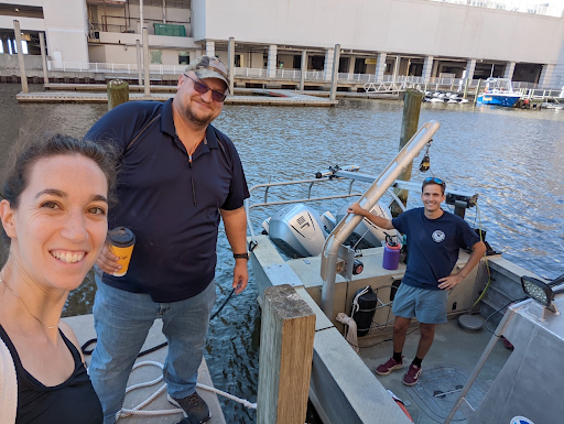 Members of the navigation response team and Marine Chart Division preparing to survey in Biloxi Bay, Mississippi. From left to right, Kathryn O'Neill, Joshua Bergeron, and LTJG Collin McMillan in front (and on deck) of the navigation response vessel.
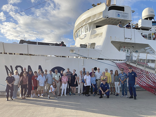 Members of the Hydrographic Services Review Panel and meeting attendees pose for a picture prior to touring NOAA Ship Rainier with assistance from Rainier's officers and crew, in Pearl Harbor, Hawaii.
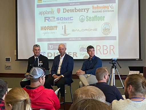 Lakebed 2030 panel discussion with, from left to right, RDML Ben Evans, Hans VanSumeren and Tim Kearns.
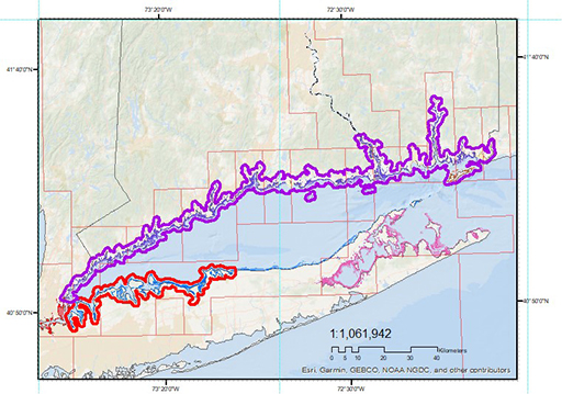 A graphic showing a map indicating areas of desired topobathy lidar acquisition along the shoreline of Long Island Sound.
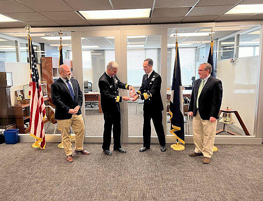 RADM Rhett Hatcher, UK National Hydrographer presents the Dalrymple award to RDML Ben Evans. Shown from left to right: John Nyberg, RDML Ben Evans, RADM Rhett Hatcher, RDML Shep Smith.