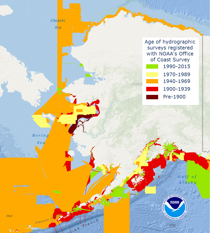
Alaska’s nautical charts need to be updated — we all know that. The diagram below shows the vintage of survey data currently used for today’s charts in Alaska. The graphic includes all surveys done by NOAA’s Office of Coast Survey (and its predecessors), and some limited data acquired by other agencies, i.e., the U.S. Coast Guard. Areas that are not colored in have never been surveyed or have data acquired by another source — from Russia or Japan, for instance — before the U.S. was responsible for charting in that area.
Continue reading “What does the age of the survey mean for nautical charts?”
Coast Survey participates in international Arctic survey project
By Edward Owens

Hello to all from the Canadian Coast Guard vessel Louis S. St-Laurent (CCG LSSL), affectionately called the ‘Louis.’ She is an impressive 120 m long, 24.5 m wide with a cruising range of 23,000 nautical miles and carries two CCG helicopters. There are 86 cabins with 100 bunks and today she currently sails with 77 souls on board. I’ve gotten lost, turned around, and confused while navigating my way through the labyrinth of neat and tidy stairways, corridors, and doorways on numerous occasions. Luckily, I’m beginning to find my way around thanks to all the artwork and placards mounted on the walls which I’ve depended on as landmarks to help me get where I’m going. Everything is arranged on five main decks. I am berthed on the 300 level or the flight and boat deck conveniently near the acoustics science lab. The galley is three decks down and as long as I can find it, I’ll be just grand.
Continue reading “Coast Survey participates in international Arctic survey project”
NOAA holds international workshop for nautical chart agencies

This week, hydrographers from 11 different countries traveled to Silver Spring, Maryland, to attend a workshop on nautical chart adequacy. Workshop participants included scholar students from the General Bathymetric Chart of the Oceans Organization, and participants from Israel, Malaysia, South Korea and United Kingdom. The workshop, developed and hosted by Coast Survey and the Joint Hydrographic Center, University of New Hampshire, trained the hydrographers on procedures to assess the adequacy of their respective nautical charts using publicly-available information.
Continue reading “NOAA holds international workshop for nautical chart agencies”
Coast Survey attends first meeting of IHO’s Nautical Information Provisions Working Group
Coast Survey attended the first meeting of the Nautical Information Provisions Working Group (NIPWG) held at the International Hydrographic Organization in Monaco.
During the meeting, Coast Survey’s Tom Loeper, chief of Navigation Services Division’s Coast Pilot branch and Great Lakes navigation manager, was reappointed as the secretary for the working group, a position he has held for 2 years. Two other working group members from the United States also attended the meeting, Briana Sullivan from the University of New Hampshire, and Mike Kushla from the National Geospatial-Intelligence Agency.
Continue reading “Coast Survey attends first meeting of IHO’s Nautical Information Provisions Working Group”


