What does a zip file have to do with historic slave ship AMISTAD?

History is never completely written. There are always new discoveries, new understanding.
NOAA historian John Cloud recently sent Coast Survey an intriguing report:

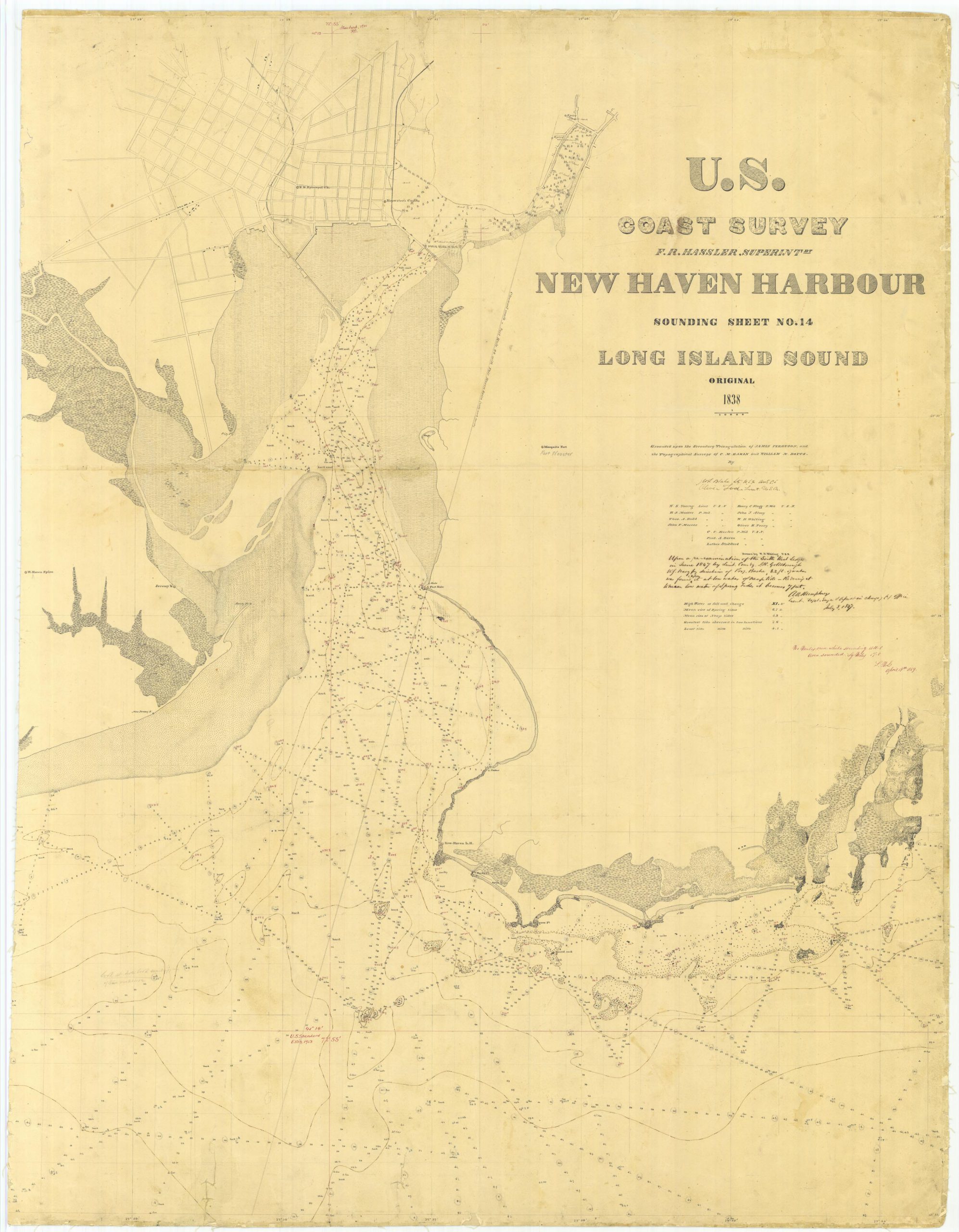
Yesterday I was looking for some historic Chesapeake Bay T sheets [topography drafts]…  Anyway, down in the bottom of a folder, there was a zipped file, dated 2009, never unzipped. I thought: well, since I have noticed this now, why don’t I unzip it? It turned out to be two overly rescaled jpgs, but using my Keith Bridge tricks [a technique developed by a former Coast Survey historical chart expert] I found the two full-scale originals. It was one chart, with a small part cut off to make two separate files: the original 1838 hydrography for New Haven Harbour!

Continue reading “What does a zip file have to do with historic slave ship AMISTAD?”

NOAA helps four ports recover from Hurricane Matthew

Matthew became a hurricane on Thursday, September 29, and it was soon clear that NOAA’s navigation services would be called into action. Coast Survey knew they would be needed for the maritime transportation system’s rapid recovery operations, to search for underwater debris and shoaling. That Saturday, while Hurricane Matthew was still three days away from hitting Haiti, Coast Survey was already ramping up preparations for assisting with reopening U.S. shipping lanes and ports after Matthew’s destruction. By Monday, as NOAA’s National Hurricane Center zeroed in on a major hit to the southeast coast, Coast Survey’s navigation service personnel began moving personnel and survey vessels for rapid deployment. Calling in survey professionals from as far away as Seattle, teams were mobilized to locations outside of the hurricane’s impact zones, so they would be ready to move in and hit the water as soon as weather and ocean conditions allowed.
Continue reading “NOAA helps four ports recover from Hurricane Matthew”

Coast Survey positioned to assist with port recovery

hurricane-canaveral
National Weather Service image of Hurricane Matthew near Port Canaveral, Florida on October 7, 2016.

As Hurricane Matthew bore down on Florida, Georgia, and South Carolina, Coast Survey pre-positioned hydrographic survey vessels for immediate deployment, to help speed the reopening of commercial shipping at ports hit by high winds and storm surge.
Currently, our Central Coast Gulf navigation manager, Tim Osborn, embedded in Port Canaveral, Florida, and our Southwest navigation manager, Kyle Ward, are coordinating marine transportation system recovery priorities with the U.S. Coast Guard and port stakeholders in Florida, Georgia, South Carolina, and North Carolina.
Continue reading “Coast Survey positioned to assist with port recovery”