
NOAA’s Office of Coast Survey maintains the nautical charts and publications for U.S. coasts and the Great Lakes. This is over a thousand charts covering 95,000 miles of shoreline and 3.4 million square nautical miles of waters. Measuring depths and determining new dangers to navigation in this large area is a monumental job given the seafloor is constantly changing.
One of NOAA Coast Survey’s biggest tasks during the winter months is to plan hydrographic survey projects for the coming field season. Survey planners consider requests from stakeholders such as marine pilots, local port authorities, the Coast Guard, and the boating community, and also consider other hydrographic priorities in determining where to survey and when. Continue reading “NOAA releases 2017 hydrographic survey season plans”
Do you need a new chart?
New update information service makes decisions easier
NOAA privatized printing of paper nautical charts in 2014 and, in the ensuing years, focused on modernizing chart compilation and production. Those recent changes allow us to update both paper and digital charts on a weekly basis. However, mariners still have had to deal with a cumbersome Local Notice to Mariners process to get important (or less than important) updates to the charts that they already own. Coast Survey is now making life a little easier for chart users. Continue reading “Do you need a new chart?”
It wasn’t just Jefferson. Congress initiated Coast Survey legislation, approved #OTD 210 years ago
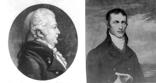
On this date in 1807, President Thomas Jefferson approved an act to provide for surveying the coasts of the United States. NOAA has long honored Jefferson — but what of the legislators who saw the need, wrote the bill, and sent it to the president?
On December 15, 1806, Samuel W. Dana (CT) introduced a resolution instructing the House of Representatives’ Committee of Commerce and Manufactures to “inquire into the expediency of making provision for a survey of the coasts of the United States, designating the several islands, with the shoals and roads, or places of anchorage, within twenty leagues of any part of the shores of the United States.” Dana was joined in debate by Jacob Crowninshield (MA-2), the chair of the Committee of Commerce and Manufactures. Continue reading “It wasn’t just Jefferson. Congress initiated Coast Survey legislation, approved #OTD 210 years ago”