
Whether navigating an oil tanker, cruise ship, fishing vessel, sailboat, or any craft, the mariner requires a suite of navigation charts that are consistent and easy to use. The public feedback we received to the National Charting Plan regarding the “sunset of paper” charts (p. 26) highlights two navigation products in particular, NOAA paper nautical charts and raster navigational chart (RNC).
Continue reading “NOAA clarifies National Charting Plan vision for production of NOAA paper charts and RNCs”
NOAA announces open house on nautical cartography
NOAA’s Office of Coast Survey is pleased to announce its first one-day open house in conjunction with the International Cartographic Conference (held this year in Washington, DC, at Marriott Wardman Park). This one-day event will focus on nautical cartography, highlighting the field of charting and GIS. It will offer nautical cartography-themed posters, presentations, tours, and exhibits. Participants will include industry partners, government agencies, and charting offices from around the world. This event is open to the public. Continue reading “NOAA announces open house on nautical cartography”
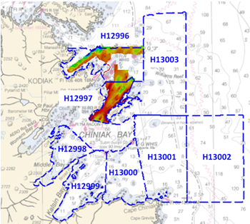
NOAA Ship Rainier surveys the waters around Kodiak Island
by ENS Michelle Levano
Kodiak Island is the 2nd largest island in the United States; it is part of the Kodiak Island Archipelago, a group of islands roughly the size of Connecticut. Due to the island’s location in the Gulf of Alaska and North Pacific Ocean, Kodiak is ranked as third in commercial fishing ports in the U.S. in terms of value of seafood landed. In 2015, the Port of Kodiak was responsible for 514 million pounds of fish and $138 million of product. More than one-third of the jobs in Kodiak are related to the fishing industry.
The Port of Kodiak is home to more than 700 commercial fishing vessels, and has more than 650 boat slips and three commercial piers that can dock vessels up to 1,000 feet. In addition to fishing, Kodiak is the hub of the Gulf of Alaska container logistics system, serving the southwest Alaskan communities with consumer goods and outbound access to the world’s fish markets. Continue reading “NOAA Ship Rainier surveys the waters around Kodiak Island”
Coast Survey hurricane prep starts now
Official hurricane season doesn’t start until June 1, but Coast Survey’s navigation managers are heavily involved throughout April and May in training exercises with the U.S. Coast Guard, ports authorities and NOAA’s National Weather Service.
Why is Coast Survey involved? With our expertise in underwater detection, NOAA navigation response teams and survey ships are often the first ones in the water after a hurricane, looking to make sure that no hidden debris or shoaling poses a danger to navigation. The faster we can advise “all clear” to the Captain of the Port, the faster the U.S. Coast Guard can re-open sea lanes for the resumption of shipping or homeland security and defense operations. So our East Coast and Gulf Coast navigation managers – who are NOAA’s “ambassadors” to the maritime public – engage with response partners during hurricane exercises. Their reports of NOAA survey capabilities and assets are an important factor in testing federal response options. Continue reading “Coast Survey hurricane prep starts now”
Teaming up with small business to expand hydrographic technology
Sandy shoals in certain near shore areas shift continuously and present a danger to navigation. It is logistically impossible to keep nautical charts current using the traditional survey methods when the bottom contours change so rapidly. NOAA’s Office of Coast Survey leverages remote sensing data in new ways to derive bathymetry for the purposes of updating nautical charts in dynamic coastal areas. An exciting new method Coast Survey is exploring is X-band radar wave imaging. Marine radar is not a new technology, however, there are advantages to exploring old technology for new purposes. Many NOAA vessels and other coastal installations are already equipped with the hardware to facilitate this type of data acquisition. Continue reading “Teaming up with small business to expand hydrographic technology”