by ENS Michelle Levano
Kodiak Island is the 2nd largest island in the United States; it is part of the Kodiak Island Archipelago, a group of islands roughly the size of Connecticut. Due to the island’s location in the Gulf of Alaska and North Pacific Ocean, Kodiak is ranked as third in commercial fishing ports in the U.S. in terms of value of seafood landed. In 2015, the Port of Kodiak was responsible for 514 million pounds of fish and $138 million of product. More than one-third of the jobs in Kodiak are related to the fishing industry.
The Port of Kodiak is home to more than 700 commercial fishing vessels, and has more than 650 boat slips and three commercial piers that can dock vessels up to 1,000 feet. In addition to fishing, Kodiak is the hub of the Gulf of Alaska container logistics system, serving the southwest Alaskan communities with consumer goods and outbound access to the world’s fish markets.

In order to access all the Port of Kodiak has to offer, vessels must first travel through Chiniak Bay, which was last surveyed as far back as 1933 via wire drag (see details in the Descriptive Report for the Wire Drag survey of Women’s Bay and St. Paul Harbor).
Today, we are going over the same areas and surveying them utilizing multibeam echo sounders to collect bathymetric soundings that measure the depth of the seafloor.
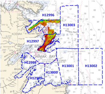
This year, Rainier is surveying the approaches to Chiniak Bay, covering the following areas: South of Spruce Island, Long Island, Middle Bay, Kalsin Bay, Isthmus Bay, Cape Chiniak, and offshore of Cape Chiniak.
Since arriving on project, Rainier has been busy surveying these areas, confirming what has already been charted, updating with more accurate depths, and finding some new features for the charts along the way! So far Rainier has patch-tested her launches to ensure survey accuracy, started work on Long Island and Kalsin Bay surveys, and established a global navigation satellite system (GNSS) base station to gain a higher positioning accuracy.
Rainier will continue to survey this area of Kodiak until mid-June. Check back on the Coast Survey blog for more status updates. Interested in visiting the ship? Rainier‘s crew will be offering tours on May 27, from 1 p.m. to 4 p.m. and May 28, from 10 a.m. to 2 p.m., at the city pier in downtown Kodiak.
Please contact NOAA Ship Rainier’s public relations officer at michelle.levano@noaa.gov for more information.


