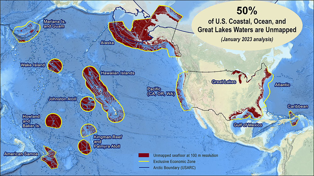
The federal Interagency Working Group on Ocean and Coastal Mapping (IWG-OCM) has released the fourth annual report on progress made in mapping U.S. ocean, coastal, and Great Lakes waters. Knowledge of the depth, shape, and composition of the seafloor has far-reaching benefits, including safer navigation, hazard mitigation for coastal resilience, preservation of marine habitats and heritage, and a deeper understanding of natural resources for sustainable ocean economies. The 2020 National Strategy for Mapping, Exploring, and Characterizing the United States Exclusive Economic Zone (NOMEC) and the Nippon Foundation-GEBCO Seabed 2030 Project make comprehensive ocean mapping a priority for the coming decade. The Unmapped U.S. Waters report tracks progress toward these important goals.
Continue reading “The Interagency Working Group on Ocean and Coastal Mapping announces progress report on mapping U.S. ocean, coastal, and Great Lakes waters”NOAA Custom Chart version 2.0 now available to the public
On February 14, 2023, NOAA’s Office of Coast Survey released NOAA Custom Chart version 2.0, a dynamic map application, which enables users to create their own paper and PDF nautical charts derived from the official NOAA electronic navigational chart (NOAA ENC®), NOAA’s premier nautical chart product.
Continue reading “NOAA Custom Chart version 2.0 now available to the public“Help keep nautical charts up to date through citizen science
NOAA maintains a suite of nearly 2000 electronic navigational charts (NOAA ENC®), as well as the ten volume United States Coast Pilot®. The seafloor and coastline are dynamic environments, which means that our products are constantly scrutinized for possible changes. Each year we make thousands of updates to ENCs, ensuring we are providing the most accurate products possible. The source data for most of these updates comes from NOAA or contractor surveys or from our federal partners, such as the U.S. Army Corps of Engineers and the U.S. Coast Guard. However, we also rely on many other data sources to help keep our ENCs up-to-date.
Continue reading “Help keep nautical charts up to date through citizen science”NOAA contributes to Empowering Women in Hydrography through at-sea experience, part 1
The Empowering Women in Hydrography project is a global effort led by the International Hydrographic Organization and Canada that seeks to initiate, organize, and track a series of activities and initiatives which will enable more women to participate equitably in the field of hydrography and to assume leadership roles within the hydrographic community. NOAA is contributing to the project via an ‘at-sea experience’ on NOAA hydrographic ships for three women each year over the four year lifespan of the project. After a global call for nominations, three women were selected to join NOAA ships for the 2022 survey season. Sub-Lieutenant Mercy Modupe Ogungbamila from the Nigerian Navy joined NOAA Ship Rainier from July 5 to 15, 2022 while surveying from Guam to Saipan.
Continue reading “NOAA contributes to Empowering Women in Hydrography through at-sea experience, part 1”The Interagency Working Group on Ocean and Coastal Mapping announces progress report on mapping U.S. ocean, coastal, and Great Lakes waters
The Interagency Working Group on Ocean and Coastal Mapping (IWG-OCM) has released the third annual report on the progress made in mapping U.S. ocean, coastal, and Great Lakes waters. Knowledge of the depth, shape, and composition of the seafloor has far-reaching benefits, including safer navigation, hazard mitigation for coastal resilience, preservation of marine habitats and heritage, and a deeper understanding of natural resources for sustainable ocean economies. The 2020 National Strategy for Mapping, Exploring, and Characterizing the United States Exclusive Economic Zone and the global Seabed 2030 initiative make comprehensive ocean mapping a priority for the coming decade. The Unmapped U.S. Waters report tracks progress toward these important goals.
Coast Survey launches NOAA Chart Display Service
The new NOAA Chart Display Service (NCDS) renders NOAA electronic navigational chart (NOAA ENC®) data with “traditional paper chart” symbology in online and offline applications for which a basemap of nautical chart data is desired, including GIS, web-based, and mobile mapping applications. The new service uses symbols, labels, and color schemes familiar to those who have used NOAA paper nautical charts or the NOAA Custom Chart application. NCDS is available as Esri REST Map Service, OGC Web Map Service (WMS), and MBTiles formats.
Continue reading “Coast Survey launches NOAA Chart Display Service”
Underway from Alaska to California encountering a new phenomenon, cellular service
By ACHST Simon Swart, Operations Officer Lt. Shelley Devereaux, and HST Adriana Varchetta
After six months of surveying in Alaska, NOAA Ship Fairweather was ready to point the bow south and set sail for San Francisco Bay. However, an unforeseen circumstance stymied the planned underway date. Although we eagerly anticipated the warmer waters of San Francisco Bay, this delay was well received by the hydrographers in the survey department and amongst the NOAA Corps officers. Our work had begun stacking up due to an extremely busy season, coupled with the fact that for most of us, this was our first time working on hydrographic project sheets. Therefore, we happily used this week of “down-time” to complete previous project sheets and plan for the upcoming survey. Those of us as sheet managers focused on cleaning multibeam data, processing backscatter mosaics, attributing features, conducting quality control checks, and writing descriptive reports. This process was greatly assisted with the help of augmenting physical scientists Pete Holmberg and Janet Hsiao. In the end, we were able to finish processing a number of sheets and reach a comfortable place on all the others. After a week of long hours, we were finally ready to toss lines and say “see you next year Alaska.”
Continue reading “Underway from Alaska to California encountering a new phenomenon, cellular service”Coast Survey to shut down the Raster Navigational Chart Tile Service and other related services
NOAA will shut down its Raster Navigational Chart (RNC) Tile Service and the online RNC Viewer on October 1, 2021. The NOAA Seamless Raster Navigational Chart Services will be shut down on January 1, 2022. This is part of a larger NOAA program to end production and maintenance of all NOAA traditional paper and raster nautical charts that was announced in the Federal Register in November 2019.
Continue reading “Coast Survey to shut down the Raster Navigational Chart Tile Service and other related services”NOAA Custom Chart version 1.0 released to the public
On April 1, 2021, NOAA’s Office of Coast Survey released NOAA Custom Chart version 1.0, a dynamic map tool which enables users to create their own paper and PDF nautical charts derived from the official NOAA electronic navigational chart (NOAA ENC®), NOAA’s premier nautical chart product.
Continue reading “NOAA Custom Chart version 1.0 released to the public”The Interagency Working Group on Ocean and Coastal Mapping announces progress report on mapping U.S. ocean, coastal, and Great Lakes waters
The Interagency Working Group on Ocean and Coastal Mapping (IWG-OCM) released the second annual report on the progress made in mapping U.S. ocean, coastal, and Great Lakes waters. The depth, shape, and composition of the seafloor are foundational data elements that we need to understand in order to explore, sustainably develop, conserve, and manage our coastal and offshore ocean resources. The 2020 National Strategy for Mapping, Exploring, and Characterizing the United States Exclusive Economic Zone and the global Seabed 2030 initiative make comprehensive ocean mapping a priority for the coming decade. The Unmapped U.S. Waters report tracks progress toward these important goals.
Continue reading “The Interagency Working Group on Ocean and Coastal Mapping announces progress report on mapping U.S. ocean, coastal, and Great Lakes waters”