NOAA announces launch of crowdsourced bathymetry database

The crowdsourced bathymetry database, displayed in the IHO Data Centre for Digital Bathymetry Data Viewer, has an updated user interface.

By Lt. Cmdr. Adam Reed, Integrated Oceans and Coastal Mapping (IOCM) assistant coordinator

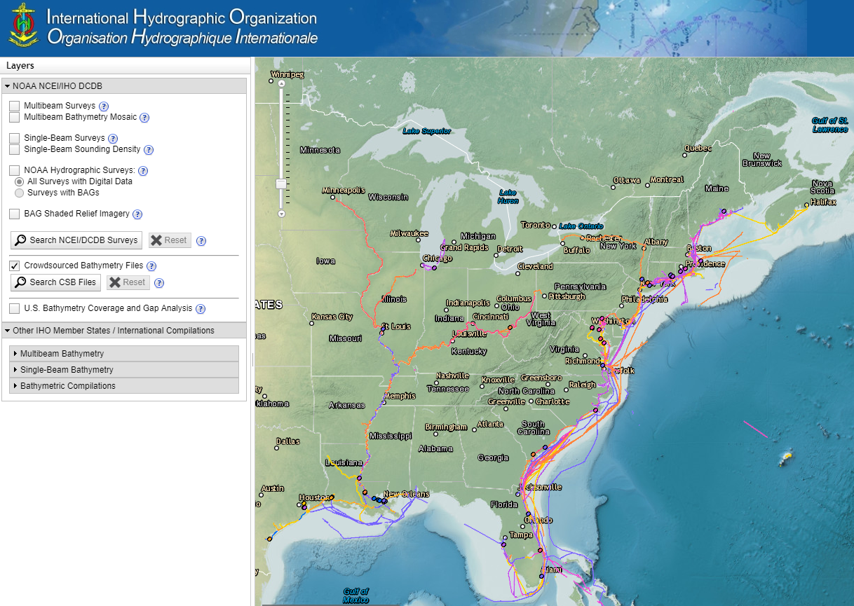
Today NOAA announces the end of a testing phase in the development of a new crowdsourced bathymetry database. Bathymetric observations and measurements from participants in citizen science and crowdsourced programs are now archived and made available to the public through the International Hydrographic Organization (IHO) Data Centre for Digital Bathymetry (DCDB) Data Viewer. The operationalized database allows free access to millions of ocean depth data points, and serves as a powerful source of information to improve navigational products.
Continue reading “NOAA announces launch of crowdsourced bathymetry database”

First U.S. federal channel using USACE survey data receives improved quality classification from NOAA

By Rachel Medley

The U.S. federal channel in the Delaware Bay is vital to maritime commerce, leading deep draft vessel traffic to and from the major ports of Wilmington, Delaware,  Philadelphia, Pennsylvania, and Camden, New Jersey. To navigate this federally maintained waterway safely and efficiently, mariners rely on the surveyed depths displayed on nautical charts. The U.S. Army Corps of Engineers (USACE) Philadelphia District regularly surveys this area, utilizing sophisticated techniques and equipment to map the depths of the seafloor. NOAA’s Office of Coast Survey, in turn, adds quality classifications to these channel depths and displays them on the nautical chart.
The portion of the federal channel from Newbold Channel Range down to the mouth of the Delaware Bay is the first waterway in the U.S. to have an improved quality classification assigned to USACE survey data—category of zone of confidence (CATZOC)  A2. Improving survey quality and upgrading the CATZOC classification allows operators to accommodate smaller margins of error while still ensuring that navigating maritime approaches and constrained environments remain safe. These decreased tolerances allow ships to maximize their loads, ultimately increasing inbound and outbound cargoes.
Continue reading “First U.S. federal channel using USACE survey data receives improved quality classification from NOAA”

Coast Survey prepares to serve nation during 2018 hurricane season

“But, sir, what does the country want in the coast survey? They want a very useful work done, a very important work done, and they want it done in the best manner.” U.S. Senator John Davis (MA), 1849, explaining the importance of the coast survey to safety and the U.S. economy during the 30th Congress, 2nd Session
As the nation’s nautical chartmaker, NOAA Coast Survey provides critical emergency response information to coastal communities and waterways. Each year, Coast Survey prepares for hurricane season in order to perform the work in—as the late Senator Davis put it—“the best manner.” Last year’s string of powerful hurricanes underscored the importance of coordinated efforts for storm preparation, response, and recovery. With the official start of the 2018 hurricane season just around the corner, Coast Survey’s regional navigation managers spent the large part of April and May meeting with U.S. Coast Guard (USCG), port authorities, NOAA National Weather Service, and communities to prepare emergency response capabilities. Continue reading “Coast Survey prepares to serve nation during 2018 hurricane season”

Poster symposium marks milestone for inaugural class of the NOAA certification program in nautical cartography

NOAA’s Christie Ence (left), Megan Bartlett (third from left), and Noel Dyer (right) explain their posters to attendees of the poster symposium at the University of Maryland.

Students of NOAA’s certification program in nautical cartography completed their final projects and presented them along with other Master of Professional Studies in GIS students during a poster symposium at the University of Maryland’s Department of Geographical Sciences. At the event, NOAA students explained their capstone projects and described how their research benefits nautical charting at NOAA. Project topics included:

  • Improving Shoreline Application to NOAA Electronic Navigational Charts, Megan Bartlet
  • An Automated Approach to Generate Nautical Vector Features from Raster Bathymetric Attributed Grid Data, Noel Dyer
  • Developing a Rasterization Procedure for Vector Chart Data, Christie Ence
  • NOAA Chart Discrepancies: A Temporal and Spatial Analysis for Navigation Response Teams, Lt. Cmdr. Matt Forney
  • Airborne Lidar Bathymetry’s Impact on NOAA Charts, Andres Garrido
  • Validating and Refining the Proposed Rescheming of NOAA Electronic Navigational Charts, Colby Harmon
  • High Resolution Bathymetry as an Alternative to Charting Controlling Depths in U.S. Army Corps of Engineers Channels, Craig Winn
  • Satellite Derived Bathymetry: An Alternative Analysis to Nautical Chart Updates, Aleah Worthem

Continue reading “Poster symposium marks milestone for inaugural class of the NOAA certification program in nautical cartography”

NOAA makes forecast data easier to display in marine navigation systems

By Neil Weston, Office of Coast Survey Technical Director

Have you ever been on the water when weather and sea conditions suddenly change? As mariners can attest, decisions need to be made quickly. Many rely on NOAA operational forecast system (OFS) data—a national network of nowcast and forecast models—to make decisions about their situation on the water. NOAA OFS are available to the mariner as data streams through a variety of websites, including nowCOAST™. However, only recently has OFS data been viewable on marine navigation systems, making it even more convenient for those needing to make critical decisions on the water.

Rose Point’s Coastal Explorer displays NOAA surface current data.
Rose Point’s Coastal Explorer, one example of many navigation software packages available, displays NOAA surface current data.

Continue reading “NOAA makes forecast data easier to display in marine navigation systems”