
It was only ten short years ago that NOAA began issuing electronic navigational charts (NOAA ENC®) as official products. As we look back, the promises of a product that emerged a decade ago continue to beckon, with even more uses and greater usage.
“We still make the traditional paper charts that mariners have depended on, but the world of navigation is changing, and Coast Survey is helping to lead that change,” explains Rear Admiral Gerd Glang, director of NOAA’s Office of Coast Survey. “Increasingly, mariners use – and soon will be required to use – electronic systems and displays to view and manage the safe navigation of their ships.”
Continue reading “After ten years of NOAA ENCs, nearly 10 million (free) downloads per month!”
NOAA observes World Hydrography Day by honoring lost crew members of the Robert J. Walker
Today, June 21, is World Hydrography Day. Hydrographic offices in over 80 maritime nations observe this day every year, since 2005. It is our special day to tell the public what hydrography is, and how it is employed to make navigation safer. Simply, hydrography is the science we use to obtain the data needed to create nautical charts. NOAA’s 200-year history is proof positive that those charts – and therefore hydrography – are a national investment that pays off daily with navigation safety, efficiency, and coastal protection from accidents at sea.
But today’s observation of World Hydrography Day is more profound. It is personal to every person who works in or supports hydrography in the United States.
Continue reading “NOAA observes World Hydrography Day by honoring lost crew members of the Robert J. Walker”
A picture is worth a thousand words – about updating Alaska charts
In late May, NOAA Ship Rainier officially started her Chatham Strait hydrographic survey project in southeast Alaska. It’s often difficult to imagine the age of many of the depth measurements depicted on Alaskan charts, but this short animation brings it home.
The older picture is U.S. Coast and Geodetic Survey Steamer Patterson and her steam-powered launch Cosmos, surveying Gut Bay in 1897. (The USC&GS is one of NOAA’s predecessor agencies, and a direct predecessor of the Office of Coast Survey.) We juxtaposed Patterson with the Rainier, who is finally able to update the bathymetry — at the exact same location — 116 years later.
Continue reading “A picture is worth a thousand words – about updating Alaska charts”
The colors of sound
One would be forgiven for thinking that measurements of the ocean floor just produce numbers. It turns out that the data acquired by sound (sonar) can be translated into some truly beautiful graphics. Check out this gorgeous digital terrain model created by Ian Colvert, a physical science technician with Coast Survey’s Navigation Response Team 6. Colvert produced the image file by processing data acquired with the team’s multibeam sonar during a recent hydrographic survey project.
The digital terrain model depicts the wreck of the freighter Fernstream, a 416-foot motor cargo vessel that sank after a collision near the entrance of the San Francisco Bay in 1952. NRT6 surveyed Fernstream as part of a recent study – identifying potential polluting shipwrecks – conducted by the Office of National Maritime Sanctuaries and the Office of Response and Restoration.
The digital terrain model depicts the wreck of the freighter Fernstream, a 416-foot motor cargo vessel that sank after a collision near the entrance of the San Francisco Bay in 1952. NRT6 surveyed Fernstream as part of a recent study – identifying potential polluting shipwrecks – conducted by the Office of National Maritime Sanctuaries and the Office of Response and Restoration.
NOAA’s latest mobile app provides free nautical charts for recreational boating
UPDATE: the beta testing period for MyNOAACharts has ended
Public is invited to try beta version of MyNOAACharts
As recreational boaters gear up for a summer of fun on coastal waters and the Great Lakes, NOAA is testing MyNOAACharts, a new mobile application that allows users to download NOAA nautical charts and editions of the U.S. Coast Pilot. The app, which is only designed for Android tablets for the testing period, was just released.
MyNOAAChart, which can be used on land and on the water, lets users find their positions on a NOAA nautical chart. They can zoom in any specific location with a touch of the finger, or zoom out for the big picture to plan their day of sailing. The Coast Pilot has geo-tagged some of the major references and provides links to appropriate federal regulations.
Continue reading “NOAA’s latest mobile app provides free nautical charts for recreational boating”
U.S. Chart No. 1 moves into electronic age
For the 65 years since the U.S. Coast and Geodetic Survey issued the first edition of U.S. Chart No.1 in 1948, mariners have had a standard guide for understanding the symbols, abbreviations and terms used on paper nautical charts. In a major step forward, a new edition of that guide also describes the symbols specified by the International Hydrographic Organization for the display of electronic navigational charts (ENC) on Electronic Chart Display and Information Systems (ECDIS).
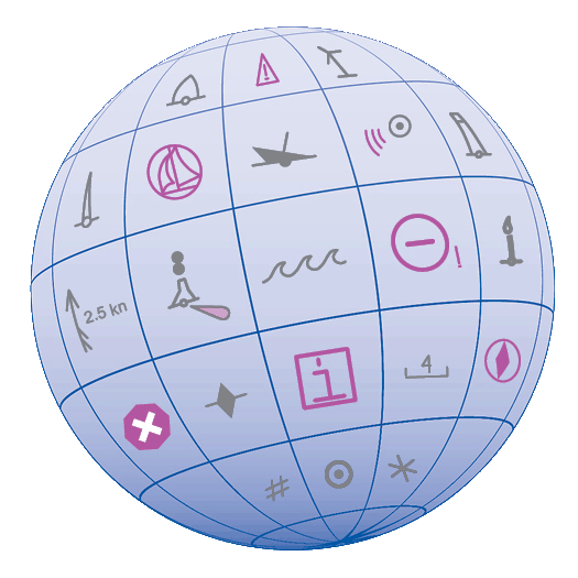 Several maritime nations produce their own versions of Chart 1. The U.S. Chart No. 1 describes the symbols used on paper nautical charts produced by NOAA and the National Geospatial-Intelligence Agency (NGA). The new U.S. Chart No. 1 is the first “Chart 1” produced by any country to show paper and electronic chart symbology side by side.
Continue reading “U.S. Chart No. 1 moves into electronic age”
NOAA’s new nautical chart improves safety for maritime gateway to the Arctic
NOAA Office of Coast Survey has released a new nautical chart for the Arctic, which will help mariners navigate the Bering Strait. Chart 16190 (Bering Strait North) incorporates precise depth measurements acquired recently by NOAA Ship Fairweather hydrographic surveys.
Coast Survey has also released a new edition of Chart 16220 (St Lawrence Island to Bering Strait).
“Our Arctic Nautical Charting Plan identified the need for 14 new charts in the Arctic,” explains Commander Shep Smith, chief of Coast Survey’s Marine Chart Division. “Chart 16190 was high on our list of priorities, since the Bering Strait is the maritime gateway from the Bering Sea in the Pacific Ocean to the Chukchi Sea in the Arctic Ocean.”
Continue reading “NOAA’s new nautical chart improves safety for maritime gateway to the Arctic”
NOAA hydro survey season underway
Spring is always a noteworthy time at Coast Survey, as the hydrographic season gets underway. This year is no exception, with some neat projects ahead.
On the East Coast, NOAA Ship Thomas Jefferson continues her work with the multi-state, multi-agency Long Island Sound Seafloor Mapping Initiative, as well as acquiring data over 87 square nautical miles in the approaches to New York to update nautical charts. In June, Thomas Jefferson begins some of her summer-long extensive 2013 post-Sandy surveys in Delaware Bay (supported by Title X, Chapter 2, of H.R. 152, the Disaster Relief Appropriations Act, 2013).
As our newest survey vessel, NOAA Ship Ferdinand Hassler, prepares for a long survey career, the crew is taking her through final repairs, upgrades, training, and inspection this spring. If all goes well, Hassler will then survey approaches to Chesapeake Bay in July, before heading to her new homeport in New Castle, New Hampshire. Once there, Hassler plans to survey approaches to New Hampshire and conduct some tests and evaluations of a new autonomous underwater vehicle (AUV) for surveying.
Continue reading “NOAA hydro survey season underway”
NOAA starts 2013 post-Sandy surveys at Statue of Liberty
NOAA kicked off its spring season for post-Sandy hydrographic work on April 11, as a navigation response team — equipped with high-tech surveying equipment — began a search for underwater storm debris and mapped the depths surrounding Liberty Island and Ellis Island. Navigation Response Team 5 wrapped up their project today, after surveying over 110 linear nautical miles. They surveyed for 119 hours, collecting over 578 million depth measurements.
In addition to surveying around Liberty Island and Ellis Island, Coast Survey’s NRT5 surveyed adjacent areas to acquire data for updates to NOAA’s nautical charts. This is the “rainbow” coverage map that shows the surveyed area. (The colors indicate depth.)

Continue reading “NOAA starts 2013 post-Sandy surveys at Statue of Liberty”
Updated Arctic chart mitigates risk for commercial transportation on the Kuskokwim
By Andrew Kampia, chief of Products Branch A, Marine Chart Division, Office of Coast Survey
When we say that many Arctic charts are lacking information critical to navigation, we’re not overstating the issue. A case in point was the 2005 edition of Chart 16304, depicting the mouth of Kuskokwim River to the City of Bethel, in Alaska. This was a preliminary chart with no hydrography, no depth measurements whatsoever.

Coast Survey just released updated NOAA Chart 16304, which now includes contemporary shoreline and hydrography. (The NOAA ENC® equivalent — US4AK85M — will be available in a month or two.)
Continue reading “Updated Arctic chart mitigates risk for commercial transportation on the Kuskokwim”