
NOAA’s Office of Coast Survey maintains the nautical charts and publications for U.S. coasts and the Great Lakes. This is over a thousand charts covering 95,000 miles of shoreline and 3.4 million square nautical miles of waters. Measuring depths and determining new dangers to navigation in this large area is a monumental job given the seafloor is constantly changing.
One of NOAA Coast Survey’s biggest tasks during the winter months is to plan hydrographic survey projects for the coming field season. Survey planners consider requests from stakeholders such as marine pilots, local port authorities, the Coast Guard, and the boating community, and also consider other hydrographic priorities in determining where to survey and when. Continue reading “NOAA releases 2017 hydrographic survey season plans”
NOAA Ship Fairweather begins multi-mission projects in Alaska
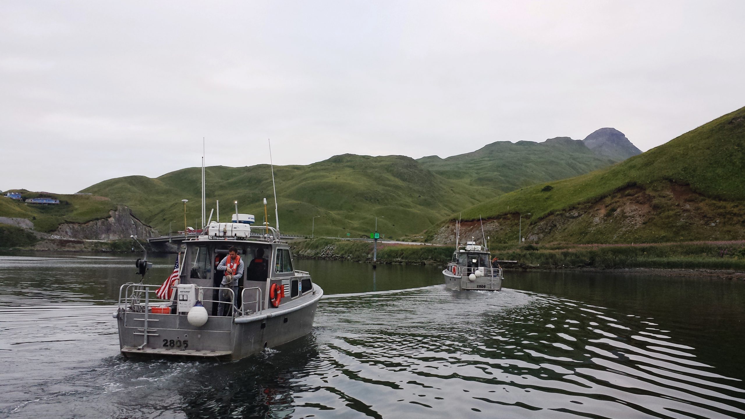
In a unique deployment of resources, last week NOAA Ship Fairweather split its scientific team and vessels to tackle two distinct projects in Alaska. Coast Survey physical scientist Katrina Wyllie and Lt.j.g. Bart Buesseler report on the multi-mission projects.
***
On August 9, NOAA Ship Fairweather departed Dutch Harbor, Alaska, for a FISHPAC project, led by Dr. Bob McConnaughey from NOAA’s Alaska Fisheries Science Center. This project’s primary mission is to statistically associate acoustic backscatter returns with the abundances of fish and crabs that frequent the Bering Sea seafloor. The science team accomplishes this with acoustic data from multibeam, single beam, and side scan sonars. Understanding the value of acoustic backscatter as a habitat-defining character will help scientists understand where fish live and the importance of different habitats. The acoustic data will also be used to correct for differences in the performance of research bottom trawls on different seafloor types, so that stock assessments and fishery management can be improved. To make sure the scientists understand what the acoustic data are showing, each day the ship will stop and collect physical bottom samples of the seafloor to see, touch, and interpret their findings. Further increasing the effectiveness of this mission, all of the multibeam bathymetry data acquired will directly support NOAA’s Office of Coast Survey as the data will be used to update soundings on the nautical charts for the eastern Bering Sea where the ship will be operating.
Continue reading “NOAA Ship Fairweather begins multi-mission projects in Alaska”
NOAA hydro field season underway
The 2014 hydrographic survey season is underway, with the NOAA fleet beginning its projects for this year.
Have you ever wondered how Coast Survey goes about determining where to survey and when? Several considerations go into prioritizing survey plans, which are laid out several years in advance. Coast Survey asks specific questions about each potential survey area.
- Is it considered a critical area? If so, how old are the most current survey data?
- Have local pilots or port authorities submitted reports of shoaling, obstructions or other concerns?
- Does the U.S. Coast Guard or other stakeholders from the maritime community (e.g., fisheries, energy, pipelines) need surveys for economic development or ecological protection?
Coast Survey’s 2014 projects reflect these priorities.
Continue reading “NOAA hydro field season underway”
NOAA Ship Fairweather surveying ports of Los Angeles and Long Beach for shipping safety
From surveying our most northern Alaskan waters last year, to our southern coastal waters this year, NOAA Ship Fairweather has really been making the hydrographic rounds, so to speak. This month, Fairweather’s hydrographic work is reaping benefits for the maritime industry in Los Angeles and Long Beach.
Fairweather is surveying this area in response to requests from the Port of Los Angeles, the Port of Long Beach, and the pilots who maneuver increasing large oil tankers and cargo ships through the area’s crowded shipping lanes. This project will acquire data for comprehensive updates to NOAA nautical charts 18749 and 18751, which provide the depth measurements and aids to navigation that mariners rely on for safe transit. Fairweather last surveyed the area in 1975, and NOAA contracted for a small survey in 2000.
Continue reading “NOAA Ship Fairweather surveying ports of Los Angeles and Long Beach for shipping safety”
NOAA’s new nautical chart improves safety for maritime gateway to the Arctic
NOAA Office of Coast Survey has released a new nautical chart for the Arctic, which will help mariners navigate the Bering Strait. Chart 16190 (Bering Strait North) incorporates precise depth measurements acquired recently by NOAA Ship Fairweather hydrographic surveys.
Coast Survey has also released a new edition of Chart 16220 (St Lawrence Island to Bering Strait).
“Our Arctic Nautical Charting Plan identified the need for 14 new charts in the Arctic,” explains Commander Shep Smith, chief of Coast Survey’s Marine Chart Division. “Chart 16190 was high on our list of priorities, since the Bering Strait is the maritime gateway from the Bering Sea in the Pacific Ocean to the Chukchi Sea in the Arctic Ocean.”
Continue reading “NOAA’s new nautical chart improves safety for maritime gateway to the Arctic”
NOAA hydro survey season underway
Spring is always a noteworthy time at Coast Survey, as the hydrographic season gets underway. This year is no exception, with some neat projects ahead.
On the East Coast, NOAA Ship Thomas Jefferson continues her work with the multi-state, multi-agency Long Island Sound Seafloor Mapping Initiative, as well as acquiring data over 87 square nautical miles in the approaches to New York to update nautical charts. In June, Thomas Jefferson begins some of her summer-long extensive 2013 post-Sandy surveys in Delaware Bay (supported by Title X, Chapter 2, of H.R. 152, the Disaster Relief Appropriations Act, 2013).
As our newest survey vessel, NOAA Ship Ferdinand Hassler, prepares for a long survey career, the crew is taking her through final repairs, upgrades, training, and inspection this spring. If all goes well, Hassler will then survey approaches to Chesapeake Bay in July, before heading to her new homeport in New Castle, New Hampshire. Once there, Hassler plans to survey approaches to New Hampshire and conduct some tests and evaluations of a new autonomous underwater vehicle (AUV) for surveying.
Continue reading “NOAA hydro survey season underway”
Combining expertise makes for better nautical charts and better understanding of fish habitats in Alaska
Today’s post is written by a guest blogger, Dr. Bob McConnaughey. Bob is the FISHPAC project chief scientist, with NOAA’s Alaska Fisheries Science Center.
Fishery biologists and hydrographers in NOAA are working together to solve two very important problems in the eastern Bering Sea. This area is one of the richest and most productive fishing grounds in the world. Careful management of harvest levels is one part of the effort to sustain these populations into the future. However, it is also important to understand the habitat requirements of the managed species so we can protect the foundation for these high levels of production.
To this end, a team of scientists at the Alaska Fisheries Science Center (AFSC) is developing mathematical models to explain the distribution and abundance of groundfish, such as pollock and cod, and benthic invertebrates, such as red king crab, in order to determine their essential habitats. The research team gathers new environmental data at locations where other AFSC scientists sample fish populations during annual bottom-trawl surveys. In many cases, existing habitat information is very limited, but studies will identify useful variables and the best tools for measuring them over large areas of the continental shelf. Continue reading “Combining expertise makes for better nautical charts and better understanding of fish habitats in Alaska”
Fairweather’s quick reminder of why we need to update Arctic nautical charts
This week the NOAA Ship Fairweather is completing her 30-day hydrographic reconnaissance survey in the Arctic. The crew’s personal observations during this successful cruise brings home the importance of measuring ocean depths and updating nautical charts with precise and accurate modern data. Ensign Owen provides Fairweather’s last blog post for this project. – DF
by Ensign Hadley Owen, NOAA, Junior Officer, NOAA Ship Fairweather (S-220)
1200 hours, Sunday, August 26, 2012:55°57.2’N 166°01.2’W, Bering Sea, approximately 100 nautical miles north of Unimak Pass
Continue reading “Fairweather’s quick reminder of why we need to update Arctic nautical charts”
NOAA Ship Fairweather: “We made it!”
by Ensign Hadley Owen, NOAA, Junior Officer, NOAA Ship Fairweather (S-220)
1200 hours, Saturday, August 18, 2012: 69°41.4’N 141°03.3’W, at anchor, 1.5 nautical miles west of Demarcation Point, on the United States/Canadian border
We made it!

I must admit, I had my doubts a week ago. But we made it safely through relatively ice-free seas to the northern border between Alaska and Canada’s Yukon Territory.
We were able to collect multibeam echo sounder data along the entire route. The area continues to be relatively shallow (8 to 25 meters) and relatively flat (1 to 1.5 meters of relief). However, dramatic ice scours and scars on the seafloor are easily visible in the data collected.
Continue reading “NOAA Ship Fairweather: “We made it!””
NOAA Ship Fairweather crew takes in Arctic beauty as they collect hydro data off Alaska’s North Slope
by Ensign Hadley Owen, NOAA, Junior Officer, NOAA Ship Fairweather (S-220)
1200 hours, August 17, 2012: 70°13.7’N 144°49.6’W, approximately 250 nautical miles along the coast SSE of Barrow, AK
The water turned a silty gray-green early afternoon yesterday, Thursday, August 16. The Fairweather was transiting through areas with depths under our keel of between 8 and 20 meters – a somewhat caution-inducing sight for a vessel of our size. But the ice has opened up and we have made it east of Barrow. We are currently the furthest east along the North Slope of any NOAA or U.S. Coast and Geodetic Survey hydrographic ship, as previous surveys were last conducted by field parties with much smaller boats, in the 1950s and 1960s. As the crow flies, we are currently 90 miles or so west of the Canadian border and our turn-around point. However, we are of course not transiting in a straight line but in the zigzag/argyle pattern, so have a bit more sea floor to cover.
Continue reading “NOAA Ship Fairweather crew takes in Arctic beauty as they collect hydro data off Alaska’s North Slope”