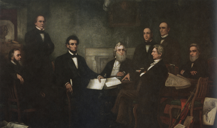
The “slave density map,” created by the men of U.S. Coast Survey in 1861, is one of Coast Survey’s most treasured historical maps. Artist Francis Bicknell Carpenter included it in his painting, “First Reading of the Emancipation Proclamation of President Lincoln,” because Lincoln consulted it so often in devising his military strategy. According to Carpenter, President Lincoln used the map in his decisions to send his armies to free blacks in some of the highest density areas in order to destabilize Southern order. Continue reading “Celebrating Abe’s birthday! Lincoln’s slave density map is home again in President Lincoln Cottage”
Coast Survey Brig Washington
Lt. Thomas R. Gedney, a U.S. Navy officer commanding the U.S. Coast Survey Brig Washington on August 20, 1839, was surveying the area between New York’s Montauk Point and Gardiner’s Island. He “discovered a strange and suspicious looking vessel off Culloden Point, near said Montauk Point,” according to his statement to Connecticut District Court Judge Andrew T. Judson. Gedney and his officers took possession of the vessel. The ship captured by the Washington proved to be the Spanish schooner called L’Amistad – the ship carrying Africans who revolted against their captors and tried to sail back to Africa… Thus began a little known piece of U.S. Coast Survey history. (It is so little known, in fact, that the 1997 movie Amistad did not mention Coast Survey.) Continue reading “Coast Survey’s little known role in the case of the Amistad”
by Dawn Forsythe, Coast Survey communications
Remember when your mom told you, “The best things come in small packages”? It turns out that is true for more than diamonds, puppies, and kids who think they are too short.
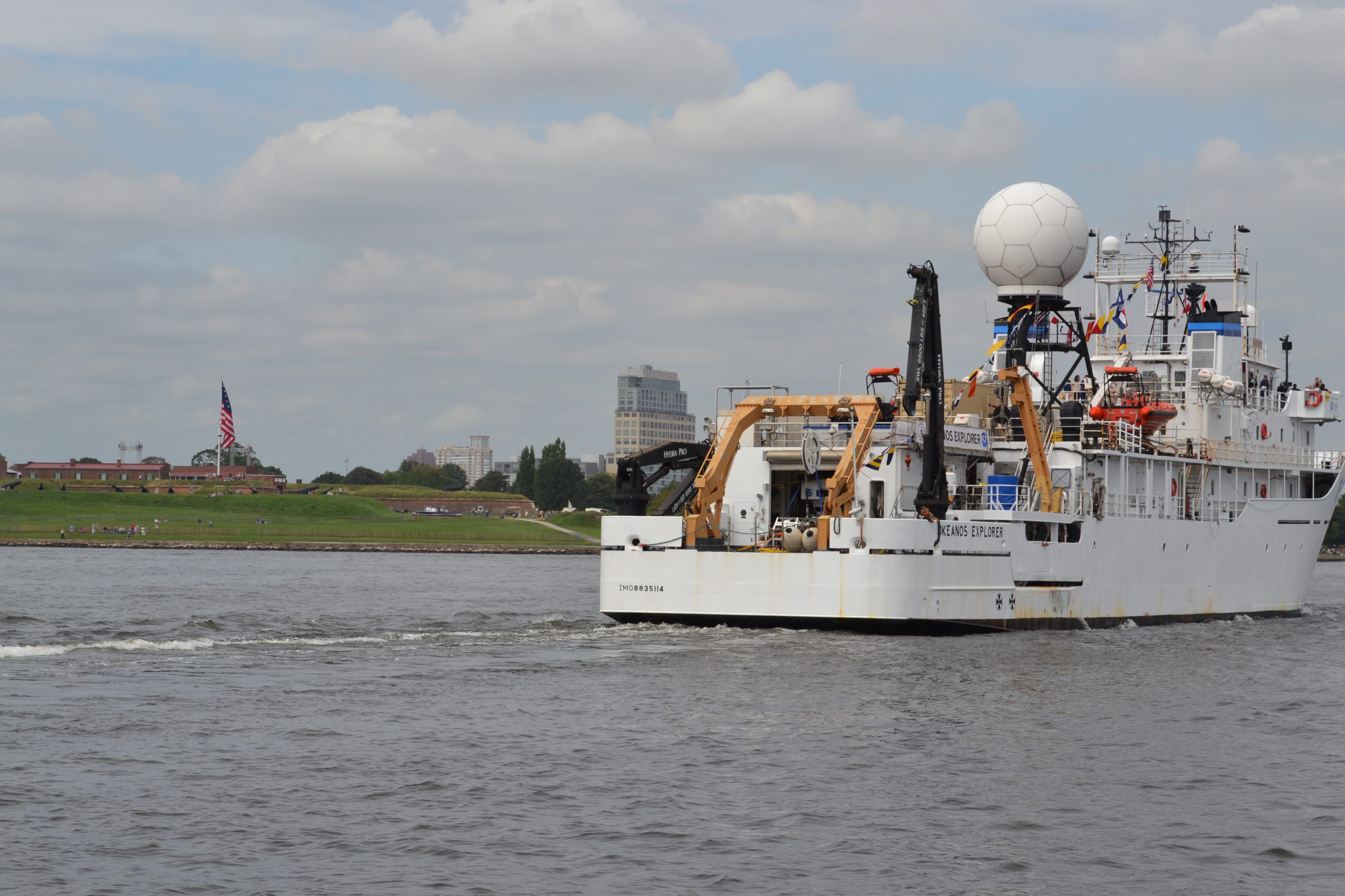
Today it was my privilege to ride with the 57-foot Bay Hydro II, one of NOAA’s smallest research vessels, as she came into Baltimore Harbor for the Star Spangled Spectacular, a festival that celebrates the 200th anniversary of our National Anthem. As we sailed alongside the impressive NOAA Ship Okeanos Explorer, past historic Fort McHenry, a 19th century cannon boomed ‒ probably sounding much as it did 200 years ago during the War of 1812, when the British attack was turned back at Baltimore. With that historic reminder, I was struck by how the Bay Hydro II represents Coast Survey’s two-century commitment to the Chesapeake Bay, starting with our surveys in 1843. Continue reading “A small hydro research vessel delivers big results”
By Darcy Herman
Over its 200-year history, NOAA’s Office of Coast Survey has employed men who are preeminent in their fields. Most of the time, their career successes follow traditional professional trajectories ‒ but at least one Coast Survey alum’s ultimate renown was born of his failure at Coast Survey. James McNeill Whistler (1834 – 1903), the American artist best known for his painting colloquially known as “Whistler’s Mother,” was briefly and unhappily employed in the drawing division of the U.S. Coast Survey in 1854 and 1855. Continue reading “Whistler hints at artistic flair during Coast Survey stint”
Knowing the locations of shipwrecks and other obstructions has always been important for safe navigation ‒ but mariners are not the only people who want to know about wrecks. They are also important for marine archeology, recreational diving, salvage operations, and fishing, among other interests. Now, Coast Survey has improved our Wrecks and Obstructions Database, giving everyone easy access to new records to explore. Coast Survey’s wrecks and obstructions database provides info on thousands of wrecks.
Historically, Coast Survey has maintained two separate sources of information on wrecks. We recently combined the sources, bringing together information on nearly 20,000 wrecks and obstructions. Continue reading “Coast Survey improves access to data on thousands of wrecks and obstructions”
NOAA announced that one of Coast Survey’s navigation response teams found the underwater wreck of the passenger steamer City of Chester, which sank in 1888 in a collision in dense fog near where the Golden Gate Bridge stands today. City of Chester had just left San Francisco and was headed up the California coast to Eureka with 90 passengers on August 22, 1888, when it was struck by the steamer Oceanic. Impaled on Oceanic, which was arriving from Asia, City of Chester remained afloat for six minutes before sinking. Sixteen people died in the accident.
Navigation Response Team 6 (NRT6) found the wreck in May 2013 while they were conducting regular survey duties for safe navigation, assessing a potential pollution threat from the S.S. Fernstream, a wreck from 1952. Sonar images confirmed that the target was the 202-foot steamship City of Chester, sitting upright, shrouded in mud, 216 feet deep at the edge of a small undersea shoal, rising 18 feet from the seabed. The City of Chester is shown in NRT6’s multibeam image. Continue reading “Coast Survey finds historic City of Chester wreck, again”
by Meredith Westington, Coast Survey geographer
Good, informed decisions are often based on analyses of historic and present conditions. Researchers, decision-makers, and amateur history buffs find detailed documentation of past conditions in the thousands of Coast Survey charts, dating back to the mid-1800s, in our Historical Map and Chart Collection.
Just like present day nautical charts, historic charts contain a wealth of information about geographic features — including their names, shape, and condition. Geographic names are important locational references for today’s emergency responders, but current and historic names also convey important aspects of local people and culture, which may persist through time. Continue reading “Geographic names disappear from charts, but not from history — #Data4Coasts”
The rebuilt “magenta line” will be a directional guide to help assure navigation safety.
The Office of Coast Survey announced today that future editions of nautical charts of the Intracoastal Waterway will be updated to include an improved “magenta line” that has historically aided navigation down the East Coast and around the Gulf Coast. Additionally, Coast Survey will change the magenta line’s function, from the perceived “recommended route” established more than a hundred years ago, to an advisory directional guide that helps prevent boaters from going astray in the maze of channels that comprise the route. Continue reading “NOAA Coast Survey to improve “magenta line” on Intracoastal Waterway nautical charts”
Paper nautical charts hold a special spot in a sailor’s heart – and in the chart table. The October announcement that the federal government will stop bulk lithographic printing of nautical charts brought some understandable angst to boaters – but fear not! NOAA may be changing the chart production process but we will NOT stop the production of paper charts. We are working with private companies to make them better: printed in brighter colors and available for fast delivery to your door. Most importantly, they are up-to-date to the moment you order it. These improved paper charts are NOAA-certified print-on-demand (POD) nautical charts, created by NOAA Coast Survey cartographers. While the lithographic paper charts will go away in 2014, anyone can order almost* any printed NOAA chart any time, from the comfort of your home, office, or boat. Just bookmark nauticalcharts.noaa.gov/pod to find the NOAA-certified chart seller who will print your chart “on demand” and ship it to you. Continue reading “NOAA’s paper nautical charts get a needed update – literally”
by Lieutenant Matt Forney and Captain Bob Pawlowski (NOAA, ret.)
July 28 marks a little-known but important milestone in our nation’s history.
On August 15, 1943, Allied forces stormed the beaches of Kiska Island, Alaska, in an attack on Japanese occupation. They found an empty island. As it happened, the Japanese Northern Army had secretly evacuated, under a cover of fog, a few weeks earlier, on July 28, thus ending the occupation of the Aleutian Islands.
Today, then, is the 70th anniversary of the last day that foreign forces occupied U.S. soil. And our Coast Survey predecessors were an important player in that event.
The U.S. Coast and Geodetic Survey was one of NOAA’s predecessor agencies. During WWII, the USC&GS sent more than a thousand civilian members and over half of its commissioned officers to the military services. (See the NOAA Central Library account, The World Wars.) Coast Surveyors served as hydrographers, artillery surveyors, cartographers, army engineers, intelligence officers, and geophysicists in all theaters of the war. Civilians, on the homefront, produced over 100 million maps and charts for the Allied forces. Eleven members of the USC&GS gave their lives during WWII.
USC&GS in the Alaska War Zone
ATTU ISLAND and KISKA ISLAND are in the Aleutian Islands, Alaska
During World War II, the Japanese Northern Army occupied Attu Island (landing there unopposed on June 7, 1942) and Kiska Island, (landing on the next day.) The Aleutian Islands were strategic, as it meant that Japan would control the North Pacific Ocean great circle route for supplies, and the U.S. feared the Japanese would turn these locations into airbases for bombing the west coast of the U.S. mainland.
On May 11, 1943, the U.S. 17th Infantry Division made an amphibious assault on the Island of Attu to retake this territory and strategic landhold. Before the Army could carry out an amphibious attack, however, they called on the men of the U.S. Coast and Geodetic Survey to conduct surveys of landings and anchorages.
The U.S. Coast and Geodetic Survey Ship Hydrographer conducted this important preemptive science to ensure the landing vessels avoided shoals and made it safely to shore. (The Hydrographer was originally built in 1930, and sailed as the USS Hydrographer after being transferred to the Navy on April 15, 1942, for the duration of World War II.) U.S. Coast and Geodetic Survey Ship Hydrographer
Following the initial assault, the Hydrographer continued surveying in Massacre Bay, Attu, to identify shoals and outline transport anchorages and supply routes.
After 19 days of fighting between the Japanese Northern Army and well-supplied U.S. forces, the Japanese forces realized that all hope of rescue was lost. They made one last banzai-style assault, and hand-to-hand battle ensued. This fighting continued until almost all the Japanese soldiers were killed. After all was said and done, 549 U.S. soldiers died, and more than a thousand were injured. The Japanese lost over 2,850 men. The U.S. only took 29 prisoners alive.
Meanwhile, the USS Hydrographer was also providing transport services to Shemya, Alaska, so the U.S. could establish a bomber airstrip for retaking Kiska.
On August 13, 1943, the Hydrographer surveyed the approaches, anchorages, and landings on Kiska to support an amphibious assault to retake this territory. Two days later, Allied Forces invaded, unaware that the Japanese had completely abandoned the island on July 28, after hearing of the fall of Attu. The invasion force consisted of 34,426 Allied troops, including elements of the 7th Infantry Division, 4th Infantry Regiment, 87th Mountain Infantry Regiment, and 5,300 Canadians (mainly the 13th Canadian Infantry Brigade from the 6th Infantry Division). Support was provided by 168 aircraft and 95 ships – including the Hydrographer.
Even though the Japanese had gone, the reoccupation came with a price. Seventeen Americans and four Canadians died from friendly fire or booby traps, 50 more were wounded from friendly fire or booby traps, and an additional 130 men came down with trench foot.
The Hydrographer has successful career
In May, 1943, the Hydrographer’s commanding officer was awarded the Legion of Merit for surveying and charting the unknown and dangerous waters surrounding Attu Island during the assault and occupation of that island.
Following her successful service in Alaska, ending the last occupation by foreign forces, the Hydrographer surveyed at Guam during amphibious operations, and at many other locations throughout the Pacific Theater of Operations. The commanding officer was awarded the Bronze Star Medal.
After the war, the Hydrographer returned to USC&GS service. She spent most of the remainder of her career surveying the Atlantic and Gulf coasts before being decommissioned in 1967, after 37 years of service to the country.