
For more than ten years, since NOAA introduced its electronic navigational charts, you have needed to purchase a specialized chart display system to view the NOAA ENC® as a seamless chart database. Starting today, you don’t need a system to view the ENC depictions; you can use Coast Survey’s new web-based viewer called NOAA ENC® Online. (IMMEDIATE CAVEAT: You still need a specialized display system to use the multi-layered functional data that make ENCs so valuable. NOAA ENC downloads are still free to the public.)

Continue reading “Coast Survey unveils NOAA ENC Online Viewer”
Better nautical chart images coming to electronic charting systems
Things are changing for U.S. nautical charts. We think you’re really going to like this improvement!
- Last week, Coast Survey announced that most of our nautical charts are available for free download as PDFs (Adobe Portable Document Format).
- Before that, we announced that the government will stop printing lithographic nautical charts after April 13, but chart users can still get printed charts from a NOAA-certified Print-on-Demand chart provider.
- Today, we have good news for boaters with electronic charting systems that use NOAA raster navigational charts (NOAA RNC®): your charts are going to be easier to read.
Continue reading “Better nautical chart images coming to electronic charting systems”
NOAA nautical charts now available as free PDFs
In case you missed it, yesterday we announced an end to government printing of lithographic nautical charts, effective April 13. Lithographs are part of Coast Survey’s proud heritage, since we started using that printing process for mass-producing charts for the Civil War, and it will be hard to see the era end. (See NOAA announces end of traditional paper chart.) While lithographic printing is scheduled to stop, however, the public will continue to be able to purchase NOAA paper charts as up-to-date print-on-demand products.
As one product ends, another begins. We also announced yesterday that our latest addition to the nautical charting portfolio is the new Portable Document Format (PDF) nautical chart, which provides up-to-date navigation information in this universally available file type. Initially, the PDF nautical charts will be available for a three-month trial, from October 22, 2013, to January 22, 2014.
Continue reading “NOAA nautical charts now available as free PDFs”
Boaters! Get free NOAA nautical products for fun and safety…
Coast Survey’s mandate is to provide nautical products that help make maritime transportation safe. As we develop and improve navigational products for commercial mariners, we also look for opportunities to serve the recreational boating community. All of the products listed below are available as free downloads.
BookletCharts™ are nautical charts in booklet form, downloadable for printing from home computers. People like to put each page into a sheet protector, and keep the updated notebooks on their boats.

For the tons (and tons) of useful information that can’t be put on the nautical charts, check out the United States Coast Pilot®, nine volumes of supplemental information important to safe and enjoyable navigation.
Continue reading “Boaters! Get free NOAA nautical products for fun and safety…”
After ten years of NOAA ENCs, nearly 10 million (free) downloads per month!
It was only ten short years ago that NOAA began issuing electronic navigational charts (NOAA ENC®) as official products. As we look back, the promises of a product that emerged a decade ago continue to beckon, with even more uses and greater usage.
“We still make the traditional paper charts that mariners have depended on, but the world of navigation is changing, and Coast Survey is helping to lead that change,” explains Rear Admiral Gerd Glang, director of NOAA’s Office of Coast Survey. “Increasingly, mariners use – and soon will be required to use – electronic systems and displays to view and manage the safe navigation of their ships.”
Continue reading “After ten years of NOAA ENCs, nearly 10 million (free) downloads per month!”
NOAA’s latest mobile app provides free nautical charts for recreational boating
UPDATE: the beta testing period for MyNOAACharts has ended
Public is invited to try beta version of MyNOAACharts
As recreational boaters gear up for a summer of fun on coastal waters and the Great Lakes, NOAA is testing MyNOAACharts, a new mobile application that allows users to download NOAA nautical charts and editions of the U.S. Coast Pilot. The app, which is only designed for Android tablets for the testing period, was just released.
MyNOAAChart, which can be used on land and on the water, lets users find their positions on a NOAA nautical chart. They can zoom in any specific location with a touch of the finger, or zoom out for the big picture to plan their day of sailing. The Coast Pilot has geo-tagged some of the major references and provides links to appropriate federal regulations.
Continue reading “NOAA’s latest mobile app provides free nautical charts for recreational boating”
U.S. Chart No. 1 moves into electronic age
For the 65 years since the U.S. Coast and Geodetic Survey issued the first edition of U.S. Chart No.1 in 1948, mariners have had a standard guide for understanding the symbols, abbreviations and terms used on paper nautical charts. In a major step forward, a new edition of that guide also describes the symbols specified by the International Hydrographic Organization for the display of electronic navigational charts (ENC) on Electronic Chart Display and Information Systems (ECDIS).
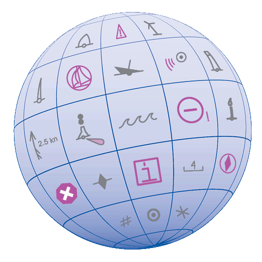 Several maritime nations produce their own versions of Chart 1. The U.S. Chart No. 1 describes the symbols used on paper nautical charts produced by NOAA and the National Geospatial-Intelligence Agency (NGA). The new U.S. Chart No. 1 is the first “Chart 1” produced by any country to show paper and electronic chart symbology side by side.
Continue reading “U.S. Chart No. 1 moves into electronic age”
NOAA’s new nautical chart improves safety for maritime gateway to the Arctic
NOAA Office of Coast Survey has released a new nautical chart for the Arctic, which will help mariners navigate the Bering Strait. Chart 16190 (Bering Strait North) incorporates precise depth measurements acquired recently by NOAA Ship Fairweather hydrographic surveys.
Coast Survey has also released a new edition of Chart 16220 (St Lawrence Island to Bering Strait).
“Our Arctic Nautical Charting Plan identified the need for 14 new charts in the Arctic,” explains Commander Shep Smith, chief of Coast Survey’s Marine Chart Division. “Chart 16190 was high on our list of priorities, since the Bering Strait is the maritime gateway from the Bering Sea in the Pacific Ocean to the Chukchi Sea in the Arctic Ocean.”
Continue reading “NOAA’s new nautical chart improves safety for maritime gateway to the Arctic”
NOAA starts 2013 post-Sandy surveys at Statue of Liberty
NOAA kicked off its spring season for post-Sandy hydrographic work on April 11, as a navigation response team — equipped with high-tech surveying equipment — began a search for underwater storm debris and mapped the depths surrounding Liberty Island and Ellis Island. Navigation Response Team 5 wrapped up their project today, after surveying over 110 linear nautical miles. They surveyed for 119 hours, collecting over 578 million depth measurements.
In addition to surveying around Liberty Island and Ellis Island, Coast Survey’s NRT5 surveyed adjacent areas to acquire data for updates to NOAA’s nautical charts. This is the “rainbow” coverage map that shows the surveyed area. (The colors indicate depth.)

Continue reading “NOAA starts 2013 post-Sandy surveys at Statue of Liberty”
Updated Arctic chart mitigates risk for commercial transportation on the Kuskokwim
By Andrew Kampia, chief of Products Branch A, Marine Chart Division, Office of Coast Survey
When we say that many Arctic charts are lacking information critical to navigation, we’re not overstating the issue. A case in point was the 2005 edition of Chart 16304, depicting the mouth of Kuskokwim River to the City of Bethel, in Alaska. This was a preliminary chart with no hydrography, no depth measurements whatsoever.

Coast Survey just released updated NOAA Chart 16304, which now includes contemporary shoreline and hydrography. (The NOAA ENC® equivalent — US4AK85M — will be available in a month or two.)
Continue reading “Updated Arctic chart mitigates risk for commercial transportation on the Kuskokwim”