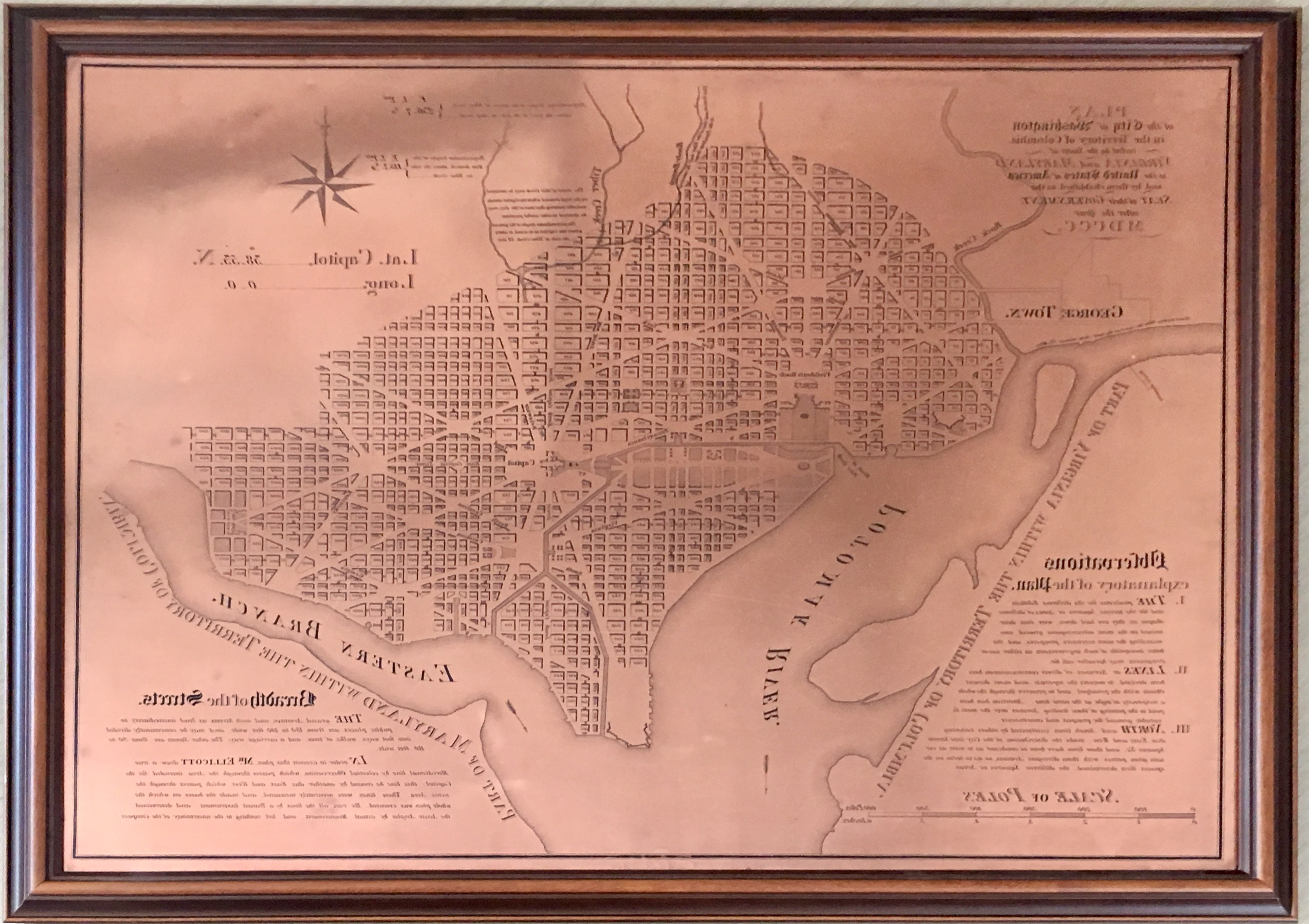
Research conducted by the NOAA Central Library uncovered a little known fact that NOAA Coast Survey’s skill in reproducing maps helped ensure that early maps of Washington, DC, and an interesting piece of history, weren’t lost. Coast Survey reproduced three historically significant maps from a copper plate engraving of Washington, DC, as surveyed by Pierre L’Enfant and Andrew Ellicott.
By Cmdr. Mark Van Waes, former commanding officer of NOAA Ship Fairweather
Mount Fairweather stands tall above Glacier Bay National Park and Preserve, dominating the skyline for miles around (when weather permits visibility). Only about 12 miles inshore from the Gulf of Alaska and soaring to 15,325 feet, it is one of the highest coastal peaks in the world.
NOAA kicked off its spring season for post-Sandy hydrographic work on April 11, as a navigation response team — equipped with high-tech surveying equipment — began a search for underwater storm debris and mapped the depths surrounding Liberty Island and Ellis Island. Navigation Response Team 5 wrapped up their project today, after surveying over 110 linear nautical miles. They surveyed for 119 hours, collecting over 578 million depth measurements.
In addition to surveying around Liberty Island and Ellis Island, Coast Survey’s NRT5 surveyed adjacent areas to acquire data for updates to NOAA’s nautical charts. This is the “rainbow” coverage map that shows the surveyed area. (The colors indicate depth.) Navigation Response Team 5 prepared this graphic depiction of their surveys of Liberty Island and adjacent areas. Continue reading “NOAA starts 2013 post-Sandy surveys at Statue of Liberty”
Countries issue advance notice for changes in electronic charts
To comply with internationally agreed practices, Canada and the U.S. have been eliminating overlapping coverage of electronic navigational charts (ENCs). New changes will soon take effect in the Great Lakes. Under the new ENC coverage scheme, each country is changing their areas of coverage so that only one country’s ENC is available for any given area at a particular scale.
These changes come into effect 0000 Coordinated Universal Time (UTC), on 22 February, 2013. Continue reading “U.S. and Canada eliminate overlapping ENC coverage in the Great Lakes”
NOAA Ship Ferdinand R. Hassler departed from NOAA’s Marine Operation Center in Norfolk this morning, to start post-SANDY surveys of critical deep water channels.
NOAA’s newest survey ship, the Ferdinand R. Hassler, began survey operations today in support of the U.S. Coast Guard efforts to re-open the Port of Virginia. Hassler was in port at NOAA’s Marine Operations Center – Atlantic in Norfolk, Virginia, for maintenance when Hurricane Sandy affected the area. The ship’s crew spent Monday completing the work and system tests necessary to get underway once the storm passed, and has now been returned to limited operational status. Continue reading “NOAA Ship Hassler starts post-SANDY survey of deep draft routes to Hampton Roads and Baltimore”
USCG Lt. Cmdr. Anne Morrisey, chief of Waterways Management Division for Sector New York, and NOAA Coast Survey navigation manager Kyle Ward discuss potential navigation response scenarios, at Sector NY Coast Guard Maritime Transportation System Recovery Unit.
As conditions go downhill, NOAA is deploying personnel and hydrographic survey assets to help speed the resumption of shipping after SANDY clears out. Coast Survey has deployed navigation managers from outside Hurricane Sandy’s areas of impact, supplemented with headquarters personnel, moving them to areas expected to be hit hard. Navigation managers are now at U.S. Coast Guard Incident Command Centers for New York – New Jersey and for Delaware Bay. We are also working with Coast Guard Captains of the Port for Virginia, Baltimore, and New England. NOAA’s navigation managers are working with the Coast Guard and the Army Corps of Engineers to coordinate deployment of NOAA’s navigation response teams (NRT) for rapid maritime response. They are also identifying vessels of opportunity, for potential use with Coast Survey’s mobile survey team (MIST). Continue reading “NOAA deploys personnel and survey assets to speed resumption of shipping after Sandy – Update 29 Oct”
LCDR Ben Evans commands NOAA’s newest survey vessel, the Ferdinand R. Hassler
Since President Thomas Jefferson asked for a survey of the coast in 1807, Coast Survey has been the nation’s trusted source for nautical charts covering the coastal waters of the U.S. and its territories. Continue reading “Meet the men and women of today’s Coast Survey”