
There are literally millions of pieces of data on nautical charts. How do cartographers determine which data to put on the charts? Two Coast Survey cartographers, Paul Gionis and Lance Roddy, explained some of the processes, protocols, and NOAA charting requirements to participants at the Florida Artificial Reef Summit earlier this month. (See the archived video of their presentation, starting at 55:40.) Among their many duties, these cartographers are responsible for vetting artificial reef public notices and permits from the U.S. Army Corps of Engineers, and for acquiring source data from the state and county reef coordinators.
By explaining the nautical chart aspects of planning, creating, and maintaining fish havens, they hoped to smooth out the permitting and charting phases.
(By the way, in case you’re wondering what we mean by “fish haven,” Coast Survey’s Nautical Chart Manual defines them as “artificial shelters constructed of rocks, rubble, boxcars, boats, concrete, special designed precast structures to enhance fish habitats, remnants of oil well structures, etc., that are placed on the sea floor to attract fish. Fish havens are often located near fishing ports or major coastal inlets and are usually considered hazards to shipping. Constructed of rigid material and projecting above the bottom, they can impede surface navigation and therefore represent an important feature for charting.”)
Permits issued by the Army Corps of Engineers are the sole source for classifying obstructions as artificial reefs and fish havens for charting purposes. Specific essential information needs to be provided for charting the areas.
- Cartographers need accurate geographic coordinates and dimensions, and the “authorized minimum clearance” (safe vessel clearance) for each distinct reef boundary.
- Importantly, the designated area cannot conflict with charted features. For instance, we cannot designate artificial reefs or fish havens in safety fairways, restricted areas, anchorages, or entrance channels. It almost goes without saying that we also don’t want to place reefs in missile test areas, or areas with pipelines, cables, or unexploded ordnance.
- The cartographers must receive notice of deployment (telling us that construction has begun).
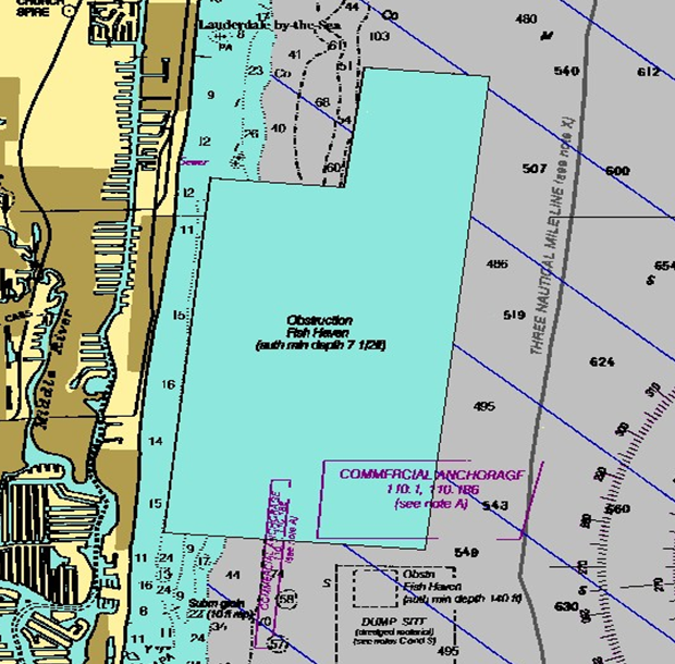
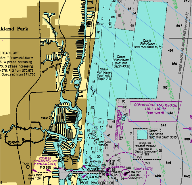
A good example of how Coast Survey works on charting artificial reefs is the initial reef proposal for Port Everglades chart 11466. The initial proposal designated a minimum clearance of 7 feet – which would prevent a mariner from transiting the area even though the water is very deep. The proposed reef area also conflicted with two established anchorages for commercial ships waiting to enter the port.

After working with the Corps of Engineers and project planners, Coast Survey was able to split the area and chart three separate bands with progressively deeper minimum depths, from seven feet to 60 feet of clearance. They also avoided overlap with the charted anchorages. The solution prevented navigation conflicts and protected the artificial reef.
The cartographers appreciated the chance to talk directly to Florida’s artificial reef community. “Events like these provide an expansive avenue to articulate Coast Survey requirements for promoting safe and efficient navigation,” Gionis points out.
Coast Survey’s navigation manager for Florida, Mike Henderson, is our charting representative on the ground in that state, and is available to work on future projects as well as answer charting inquiries in general.
Outstanding article on a complicated process. Nicely done!
Reblogged this on Boating Safety Tips, Tricks & Thoughts from Captnmike and commented:
A nice explanation on how NOAA, The Army Corps of Engineers and others work together to improve fish habitat while keeping the waters safe for boaters and freighters.