NOAA Science Camp brings hydro education to life

Congratulations to our colleagues in Seattle for hosting a terrific NOAA Science Camp this month! Held at NOAA’s Seattle Sand Point facility each July, NOAA Science Camp offers opportunities for middle school students and high school students.
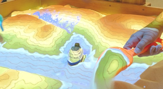
Thanks to Coast Survey experts stationed at our Pacific Hydrographic Branch, a section of the classes was focused on hydrography. Kids learned about bathymetry and the importance of hydrographic surveys for shipping. They saw how high-resolution sonar data is used for tsunami modeling and fish habitat.
Continue reading “NOAA Science Camp brings hydro education to life”

Commerce Secretary Pritzker attends Hassler change of command

Secretary Pritzker and LCDR Jaskoski

On July 21, U.S. Secretary of Commerce Penny Pritzker attended the change-of-command ceremony for NOAA Ship Ferdinand R. Hassler, one of NOAA’s hydrographic survey vessels that collect data for creating the nation’s nautical charts.
At the ceremony, Lt. Cmdr. Matthew Jaskoski assumed command from Lt. Cmdr. Briana Welton, who served as Hassler’s third commanding officer and will become the chief of Coast Survey’s Atlantic Hydrographic Branch. Jaskoski previously served as executive officer for NOAA Ship Fairweather.
Sec. Pritzker’s remarks highlighted Hassler’s contributions since its commissioning just over four years ago, including its completion of 46 hydrographic surveys and the ship’s contribution to re-opening East Coast sea traffic after Hurricane Sandy. She also reminded the officers and crew of the legacy they honor in their contributions to our nation’s coastal intelligence.
Continue reading “Commerce Secretary Pritzker attends Hassler change of command”

NOAA hosts international “Chart Adequacy Workshop”

Cartographers and hydrographers from twelve countries gathered in Maryland last week to participate in a three-day NOAA workshop on evaluating the adequacy nautical charts. During the workshop, they learned techniques to evaluate the suitability of nautical chart products using chart quality information and publicly available information. The participants then generated key layers in adequacy assessments:

  • Using automatic identification systems (AIS) information to classify navigational routes, they generated a vessel traffic layer.
  • Comparing satellite-derived bathymetry or other surveys of opportunity with the existing chart, to identify areas that showed significant bathymetric changes, they generated a bathymetric difference layer.
  • Classifying chart quality information, they generated a hydrographic characteristics layer.

Continue reading “NOAA hosts international “Chart Adequacy Workshop””

Updating digital nautical charts is faster and easier

Coast Survey introduces new service for downloading raster chart updates

We click on our smart phone map app, and we can immediately see any place on land. We turn on our boat’s navigational system and a nautical chart appears. Where do the apps get their maps and charts, and how often are they updated? Let’s look deeper into the chart services…
Recreational boaters use chart plotters and computer-based navigation systems, including tablets and mobile devices — at last count, there are over 60 mobile apps — as well as web mapping applications. These commercial products often use privately produced charts derived from official NOAA raster navigational charts (NOAA RNC®). In recent years, larger manufacturers have switched to using NOAA raster charts themselves. Until recently, the systems had to work through a major problem: each of NOAA’s thousand charts is a huge file that takes bandwidth and time to upload. So the entrepreneurs developed work-arounds, especially when they needed to update the charts. Many of them cut NOAA chart files into more manageable “tiles.” Many didn’t update these chart tiles for months, or sometimes even up to a year, despite NOAA issuing updates weekly, often because of time and storage space problems.
Continue reading “Updating digital nautical charts is faster and easier”