NOAA improves coastal resilience tools for U.S. Pacific Islands vulnerable to natural disasters

NOS tide and surge guidance coverage over the Pacific.

By Jack Riley and Sergey Vinogradov, Ph.D.

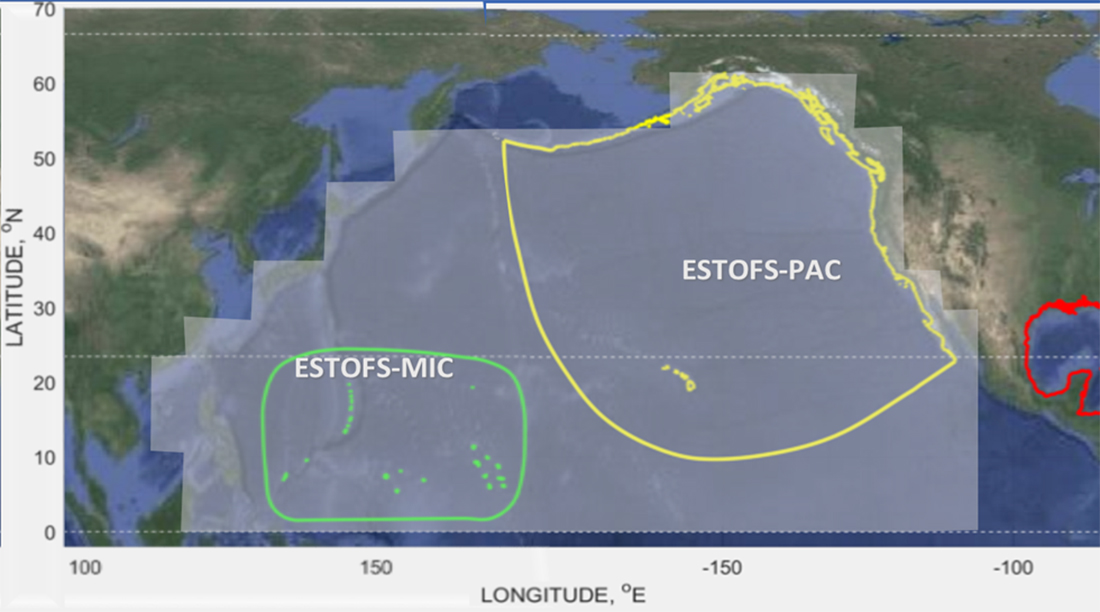
The Pacific Ocean is the largest and deepest of Earth’s oceanic divisions. It extends from the Arctic Ocean in the north to the Southern Ocean in the south and is bound by the continents of Asia and Australia in the west and the Americas in the east. Most of the U.S. Pacific territories are located in the northern half of the Pacific Ocean and are among the Pacific Islands that are highly exposed to natural disasters. As part of NOAA’s coastal resilience efforts, the National Ocean Service (NOS) is developing better tools to define changes in water level related to tropical cyclones and other weather related conditions. This work is part of the global effort to develop disaster risk assessment tools and practical technical applications to reduce and mitigate coastal countries’ vulnerability to natural disasters.

Continue reading “NOAA improves coastal resilience tools for U.S. Pacific Islands vulnerable to natural disasters”

Follow the status of electronic navigational chart improvements with NOAA’s new map viewer

New Jersey and surrounding area displayed in the new web map service.

NOAA’s Office of Coast Survey released a new and improved map viewer featuring the status of NOAA electronic navigational charts (NOAA ENC®) as they undergo major improvements. The data is also available as a GIS map service. The public can now view ENC project status from the planning and creation stages all the way to completion, keeping them better informed when these enhanced navigational charts become available.

Continue reading “Follow the status of electronic navigational chart improvements with NOAA’s new map viewer”

NOAA announces new progress report on mapping U.S. ocean, coastal, and Great Lakes waters

Map showing the geographic distribution and extent of the unmapped areas within U.S. waters. Analysis conducted in January 2020.

NOAA released the first annual report on the progress made in mapping U.S. ocean, coastal, and Great Lakes waters. The depth, shape, and composition of the seafloor are foundational data elements that we need to understand in order to explore, sustainably develop, conserve, and manage our coastal and offshore ocean resources. The 2019 Presidential Memorandum on Ocean Mapping of the United States Exclusive Economic Zone and the Shoreline and Nearshore of Alaska and the global Seabed 2030 initiative make comprehensive ocean mapping a priority for the coming decade. The Unmapped U.S. Waters report tracks progress toward these important goals.

Continue reading “NOAA announces new progress report on mapping U.S. ocean, coastal, and Great Lakes waters”

Nautical Charts: Marine Navigation Joins the Geospatial Revolution

Electronic navigational chart displayed on an Electronic Chart Display and Information System (ECDIS) on NOAA Ship Thomas Jefferson.

By Rear Adm. Shepard M. Smith

When I traveled around Europe as a young man, my first stop upon leaving the train station in a new city was at the tourist bureau kiosk for a paper city map. On a recent trip to Malaysia, I used my phone to find walking instructions to a street market across town. When I arrived, I described my route to my host, who said that the pedestrian bridge I had used only opened the week before.

Continue reading “Nautical Charts: Marine Navigation Joins the Geospatial Revolution”

Coast Survey Spotlight: MaryRose Sheldon

MaryRose Sheldon became attached to the idea of working for NOAA while in college, because the mission and work aligned with her values and passions.

Ever wonder what it’s like to be a member of the NOAA Coast Survey team? We use the Coast Survey spotlight blog series as a way to periodically share the experiences of Coast Survey employees as they discuss their work, background, and advice.


MaryRose Sheldon, marine cartographer

“Mariners use our products to pilot our nation’s waters, and they rely on us to bring attention to obstacles to navigation.”

Continue reading “Coast Survey Spotlight: MaryRose Sheldon”