We hear about the infrastructure investments that often follow major disasters like hurricanes ‒ the “hard” port resilience strategies necessary in the wake of catastrophic human, environmental, and economic loss. But the sturdiest, most flood-proof building is just one part of a larger system of assets in coastal resilience. We don’t hear much about the “soft” resilience strategies ‒ those that build and maintain ties among the people responsible for responding to a hurricane, for instance ‒ that are important to a successful response. Those strategies are part of the social capital between communities and government, and among government agencies.

Continue reading “A “soft” resilience strategy is part of successful hurricane response”
Coast Survey finds historic City of Chester wreck, again
NOAA announced that one of Coast Survey’s navigation response teams found the underwater wreck of the passenger steamer City of Chester, which sank in 1888 in a collision in dense fog near where the Golden Gate Bridge stands today. City of Chester had just left San Francisco and was headed up the California coast to Eureka with 90 passengers on August 22, 1888, when it was struck by the steamer Oceanic. Impaled on Oceanic, which was arriving from Asia, City of Chester remained afloat for six minutes before sinking. Sixteen people died in the accident.
Navigation Response Team 6 (NRT6) found the wreck in May 2013 while they were conducting regular survey duties for safe navigation, assessing a potential pollution threat from the S.S. Fernstream, a wreck from 1952. Sonar images confirmed that the target was the 202-foot steamship City of Chester, sitting upright, shrouded in mud, 216 feet deep at the edge of a small undersea shoal, rising 18 feet from the seabed.

Continue reading “Coast Survey finds historic City of Chester wreck, again”
NOAA hydro field season underway
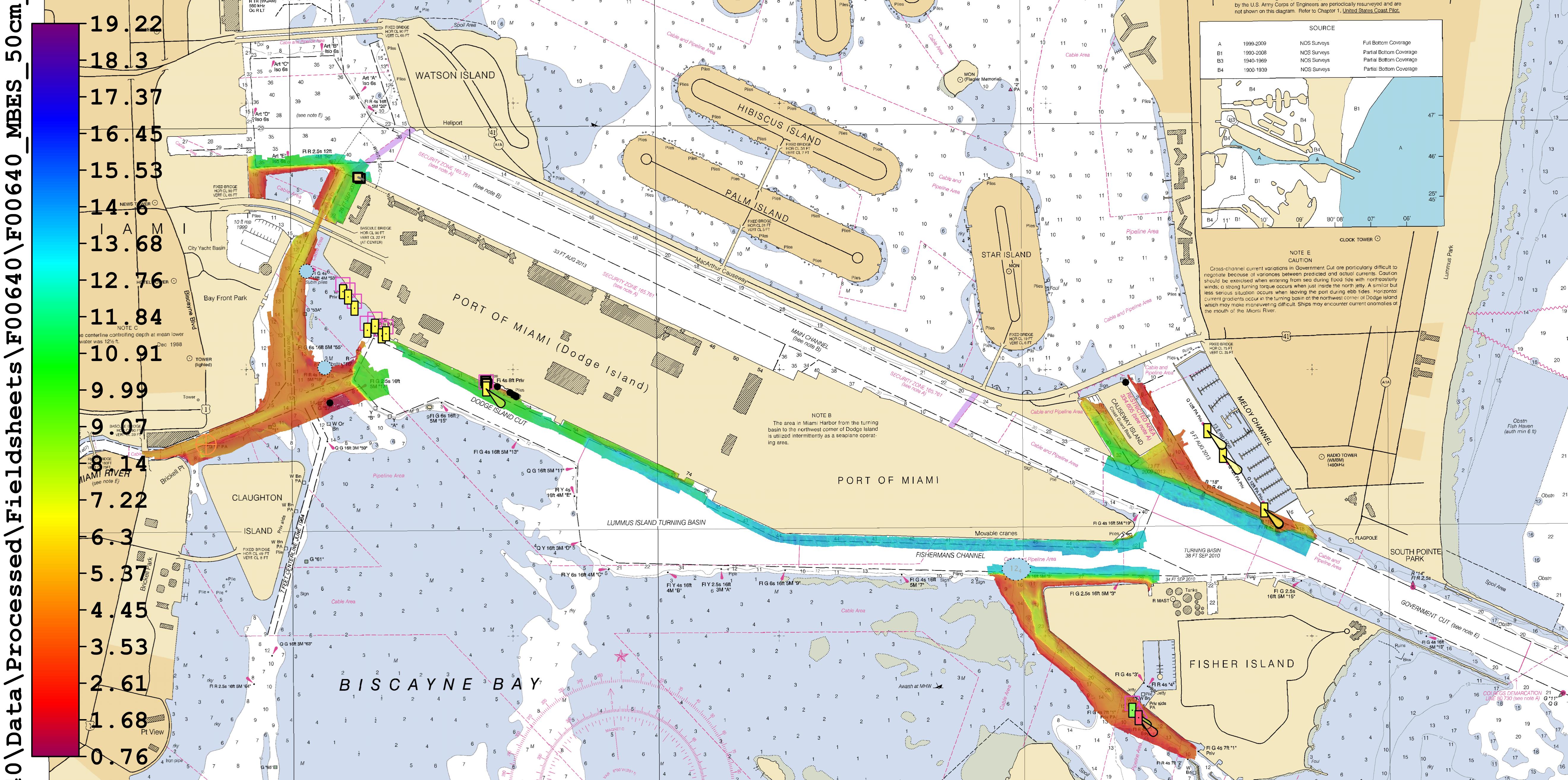
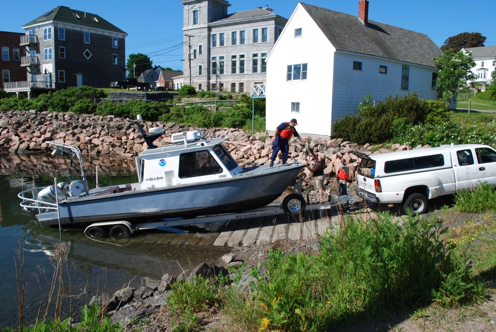
The 2014 hydrographic survey season is underway, with the NOAA fleet beginning its projects for this year.
Have you ever wondered how Coast Survey goes about determining where to survey and when? Several considerations go into prioritizing survey plans, which are laid out several years in advance. Coast Survey asks specific questions about each potential survey area.
- Is it considered a critical area? If so, how old are the most current survey data?
- Have local pilots or port authorities submitted reports of shoaling, obstructions or other concerns?
- Does the U.S. Coast Guard or other stakeholders from the maritime community (e.g., fisheries, energy, pipelines) need surveys for economic development or ecological protection?
Coast Survey’s 2014 projects reflect these priorities.
Continue reading “NOAA hydro field season underway”
Navigation Response Team 1 finds vehicle during survey of Intracoastal Waterway, assists sheriff’s office
While surveying the approaches to Panama City (FL), St Andrews Bay, and West Bay, Coast Survey’s Navigation Response Team 1 recently made an unexpected find. When team members Mark McMann and Aurel Piantanida reviewed hydrographic data collected with their side scan sonar and multibeam echo sounder, they discovered an upside-down vehicle in Panama City’s West Bay Creek, part of the Intracoastal Waterway (see chart 11385).

Continue reading “Navigation Response Team 1 finds vehicle during survey of Intracoastal Waterway, assists sheriff’s office”
NOAA navigation response teams improve charts for ships transiting Miami and San Francisco
Coast Survey’s navigation response teams, which are 3-person hydrographic survey teams on small boats, have made a fast start on this year’s survey season.
In Florida, where Coast Survey is preparing to issue a “new and improved” Miami Harbor Chart 11468 to alleviate vessel congestion at the Port of Miami, a navigation response team finished final hydrographic surveys to ensure the new chart has the latest and most accurate depth measurements around several areas identified as critical within the port. In just ten days, team members Erik Anderson, James Kirkpatrick, and Kurt Brown acquired, processed, and submitted the multibeam survey data covering 64 nautical miles.

Continue reading “NOAA navigation response teams improve charts for ships transiting Miami and San Francisco”
The colors of sound
The digital terrain model depicts the wreck of the freighter Fernstream, a 416-foot motor cargo vessel that sank after a collision near the entrance of the San Francisco Bay in 1952. NRT6 surveyed Fernstream as part of a recent study – identifying potential polluting shipwrecks – conducted by the Office of National Maritime Sanctuaries and the Office of Response and Restoration.
NOAA hydro survey season underway
Spring is always a noteworthy time at Coast Survey, as the hydrographic season gets underway. This year is no exception, with some neat projects ahead.
On the East Coast, NOAA Ship Thomas Jefferson continues her work with the multi-state, multi-agency Long Island Sound Seafloor Mapping Initiative, as well as acquiring data over 87 square nautical miles in the approaches to New York to update nautical charts. In June, Thomas Jefferson begins some of her summer-long extensive 2013 post-Sandy surveys in Delaware Bay (supported by Title X, Chapter 2, of H.R. 152, the Disaster Relief Appropriations Act, 2013).
As our newest survey vessel, NOAA Ship Ferdinand Hassler, prepares for a long survey career, the crew is taking her through final repairs, upgrades, training, and inspection this spring. If all goes well, Hassler will then survey approaches to Chesapeake Bay in July, before heading to her new homeport in New Castle, New Hampshire. Once there, Hassler plans to survey approaches to New Hampshire and conduct some tests and evaluations of a new autonomous underwater vehicle (AUV) for surveying.
Continue reading “NOAA hydro survey season underway”
NOAA starts 2013 post-Sandy surveys at Statue of Liberty
NOAA kicked off its spring season for post-Sandy hydrographic work on April 11, as a navigation response team — equipped with high-tech surveying equipment — began a search for underwater storm debris and mapped the depths surrounding Liberty Island and Ellis Island. Navigation Response Team 5 wrapped up their project today, after surveying over 110 linear nautical miles. They surveyed for 119 hours, collecting over 578 million depth measurements.
In addition to surveying around Liberty Island and Ellis Island, Coast Survey’s NRT5 surveyed adjacent areas to acquire data for updates to NOAA’s nautical charts. This is the “rainbow” coverage map that shows the surveyed area. (The colors indicate depth.)

Continue reading “NOAA starts 2013 post-Sandy surveys at Statue of Liberty”
Coast Survey supports inauguration preparations
It was an honor to assist with preparations for the Presidential Inaugural. Our assistance, provided before the event, was a combined effort by one of our navigation response teams, survey technicians, cartographers, and several NOAA officers. Coast Survey’s work was additionally supported by colleagues at NOAA’s Center for Operational Oceanographic Products and Services.

For more about navigational planning for the Potomac River, see Coast Guard to establish security zone for the presidential inauguration.
Surveys for Maine fishing community buttress new energy technology
By David McIntire, survey technician, Coast Survey Navigation Response Team 4
Down East Maine. For many, this conjures up imagery of rugged, fog-enshrouded coastline carved for centuries by relentless waves and violent nor’easters, where quaint fishing villages and misty lighthouses hug the shoreline, inhabited by hardy mariners who for generations have braved fierce storms and unimaginable winters to make a living where land and sea meet in perhaps the most spectacular way. Yet this is only part of the story where a nostalgic past embraces an innovative future. Eastport, Maine is no exception and NOAA’s Office of Coast Survey is proud to partner in that endeavor.
Fishing has been the lifeblood of Eastport’s economy for generations and, despite the influx of tourism in recent decades, many Down East families still derive their income from the sea. This may sound quaint and romantic, until you realize that the Bay of Fundy is not the idyllic, placid water of postcards and paintings. With tides ranging nearly 30 feet every few hours, inlets become rife with ripping currents as the back bays fill and empty through these narrow, rocky channels. It is within this treacherous environment that the local commercial fishermen risk their lives – and, over the past decade, a number of them have paid the ultimate price.

Continue reading “Surveys for Maine fishing community buttress new energy technology”
