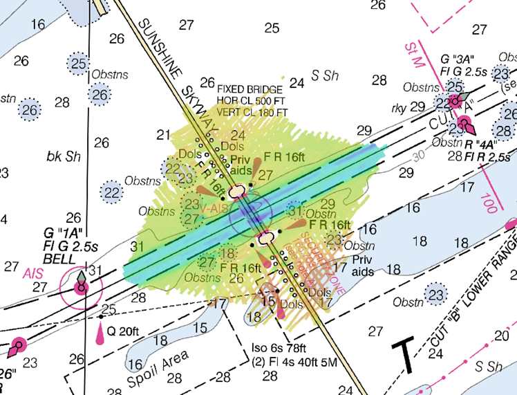
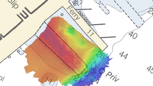
NOAA’s navigation response team 2 (NRT2), homeported in Fernandina Beach, Florida, conducted a survey around the Sunshine Skyway Bridge, which spans Tampa Bay. The U.S. Coast Guard (USCG) and additional members of the Tampa Bay Harbor Safety Committee requested the work and expressed interest in establishing alternate routes for recreational boating traffic. Alternative routes will alleviate increasing congestion where the main ship channel passes beneath the bridge. This area is naturally restrictive to navigation and, as a result, there have been multiple accidents and near accidents here in the past. Continue reading “NOAA surveys for recreational boat traffic safety in Tampa Bay”
NOAA releases 2018 hydrographic survey season plans
NOAA hydrographic survey ships and contractors are preparing for the 2018 hydrographic survey season. Operations are scheduled for maritime priority areas around the country and are outlined in Coast Survey’s living story map.
Continue reading “NOAA releases 2018 hydrographic survey season plans”
The second launching of the first Coast and Geodetic Survey ship PATHFINDER
Today the NOAA Central Library unveiled the newly restored painting, Pathfinder, painted in 1899 by renowned maritime artist, Antonio Jacobsen. Included as part of the NOAA Central Library Rare Books collection, the painting is the oldest extant painting of a NOAA ancestor ship in the possession of NOAA.
Continue reading “The second launching of the first Coast and Geodetic Survey ship PATHFINDER”
Introducing New Gulf of Maine Operational Forecast System
This month, NOAA unveiled the new Gulf of Maine Operational Forecast System (GoMOFS). This system provides users with real-time and forecasts of surface water levels, 3-D fields of water currents, water temperature, and salinity out to 72 hours. GoMOFS predictions support safe and efficient marine navigation, allowing mariners to plan their routes and avoid accidents. The system’s nowcasts and forecasts can also aid in emergency response, ecological applications, coastal management, and harmful algal bloom forecasts. Continue reading “Introducing New Gulf of Maine Operational Forecast System”
Surveyor Spotlight: NOAA navigation response team member, Erin Diurba
Have you ever wondered what it is like to work on a NOAA navigation response team (NRT) or what makes our team members experts in their field?
The Office of Coast Survey deploys NRTs across the country to conduct emergency hydrographic surveys requested by the U.S. Coast Guard, port officials, and other first responders in the wake of accidents and natural events that create navigation hazards. In their day‐to‐day, non‐emergency role, the NRTs work in the nation’s busiest ports, surveying for dangers to navigation and updating nautical chart products.
Meet Erin Diurba, a NOAA navigation response team member homeported in Galveston, Texas. Her self-described “survey wanderlust” has taken her across the globe to gain hydrographic surveying expertise on diverse teams and in unique environments. She tells her story here in this story map.
Continue reading “Surveyor Spotlight: NOAA navigation response team member, Erin Diurba”NOAA navigation response team responds after ferry strikes submerged object
By Lt. j.g. Dylan Kosten
On November 27, 2017, a New York City ferry departing from Pier 11 in the East River struck an underwater pylon, stranding over 100 passengers. The pylon was most likely from the remains of an old pier demolished several years earlier. At the request of the U.S. Coast Guard (USCG), NOAA’s navigation response team 5 (NRT 5), homeported in New London, Connecticut, assisted in the investigation.
Continue reading “NOAA navigation response team responds after ferry strikes submerged object”
NOAA Corps officers play important role in hydrography at NOAA
By Nick Perugini
In 2017, we celebrated the NOAA Corps Centennial, marking 100 years of valued service to the nation. Today’s NOAA Corps officers play an important role in the Office of Coast Survey. Officers serve as field hydrographers, technical experts, and managers throughout the charting organization. There is a distinct career path for NOAA Corps officers in Coast Survey that provides the opportunity to develop technical expertise in hydrography and at the same time, advance in rank in the NOAA Corps.
Continue reading “NOAA Corps officers play important role in hydrography at NOAA”
NOAA Office of Coast Survey wraps up a busy 2017 hurricane season
The 2017 Atlantic hurricane season was powerful, with the strongest storms occurring consecutively from late August to early October. The sequential magnitude of four hurricanes in particular—Harvey, Irma, Maria, and Nate—made response efforts challenging for NOAA’s Office of Coast Survey. Coast Survey summarized this season’s response efforts along with the efforts of NOAA Ship Thomas Jefferson (operated by NOAA’s Office of Marine and Aviation Operations) in the following story map. Continue reading “NOAA Office of Coast Survey wraps up a busy 2017 hurricane season”
NOAA completes multi-year ocean mapping project off the Olympic Coast
In September 2017, NOAA’s Integrated Ocean and Coastal Mapping Program completed a multi-year ocean mapping project off the coast of Washington in Olympic Coast National Marine Sanctuary. This project grew out of a seafloor mapping prioritization exercise led by NOAA’s National Centers for Coastal Ocean Science on behalf of the State of Washington in May 2015. The prioritization exercise integrated the priorities of coastal stakeholders representing numerous federal and state (Oregon and Washington) agencies, coastal treaty tribes, and academic institutions to determine where to concentrate future survey efforts. One identified priority was the need for a better understanding of the bathymetry and habitats of Washington’s submarine canyons, particularly three offshore areas in need of enhanced data collection efforts. Continue reading “NOAA completes multi-year ocean mapping project off the Olympic Coast”
NOAA Office of Coast Survey to launch redesigned website
NOAA’s Office of Coast Survey will launch the newly redesigned website, nauticalcharts.noaa.gov, on November 14, 2017. The website will feature simplified navigation and a responsive layout for all platforms, making your favorite NOAA charting products easy and convenient to find.
Continue reading “NOAA Office of Coast Survey to launch redesigned website”
