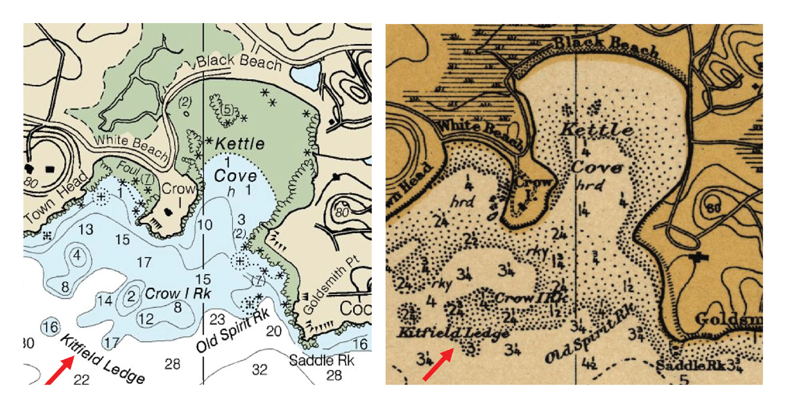
Most NOAA Office of Coast Survey customers have a practical mariner’s bent—they are interested in up-to-date and accurate navigational products and services. However, an increasing number of customers are using Coast Survey online resources for historical research.
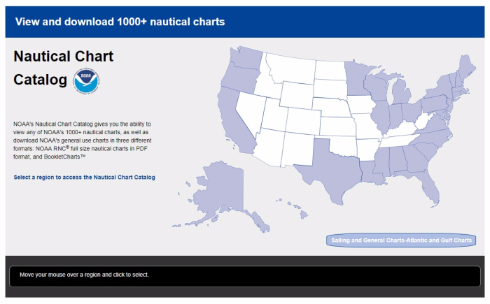
With NOAA’s new Nautical Chart Catalog, users can readily access raster data and charting products in list format. The website serves as a complement to the Chart Locator by providing search capability for any of NOAA’s thousand plus nautical charts.
Recently, NOAA hosted it’s third NOAA Industry Day at the Annapolis Yacht Club, attracting over two dozen prominent maritime application and navigation system developers. This year’s event focused on NOAA’s extensive data and models that are freely available and of particular interest to the recreational boater community.
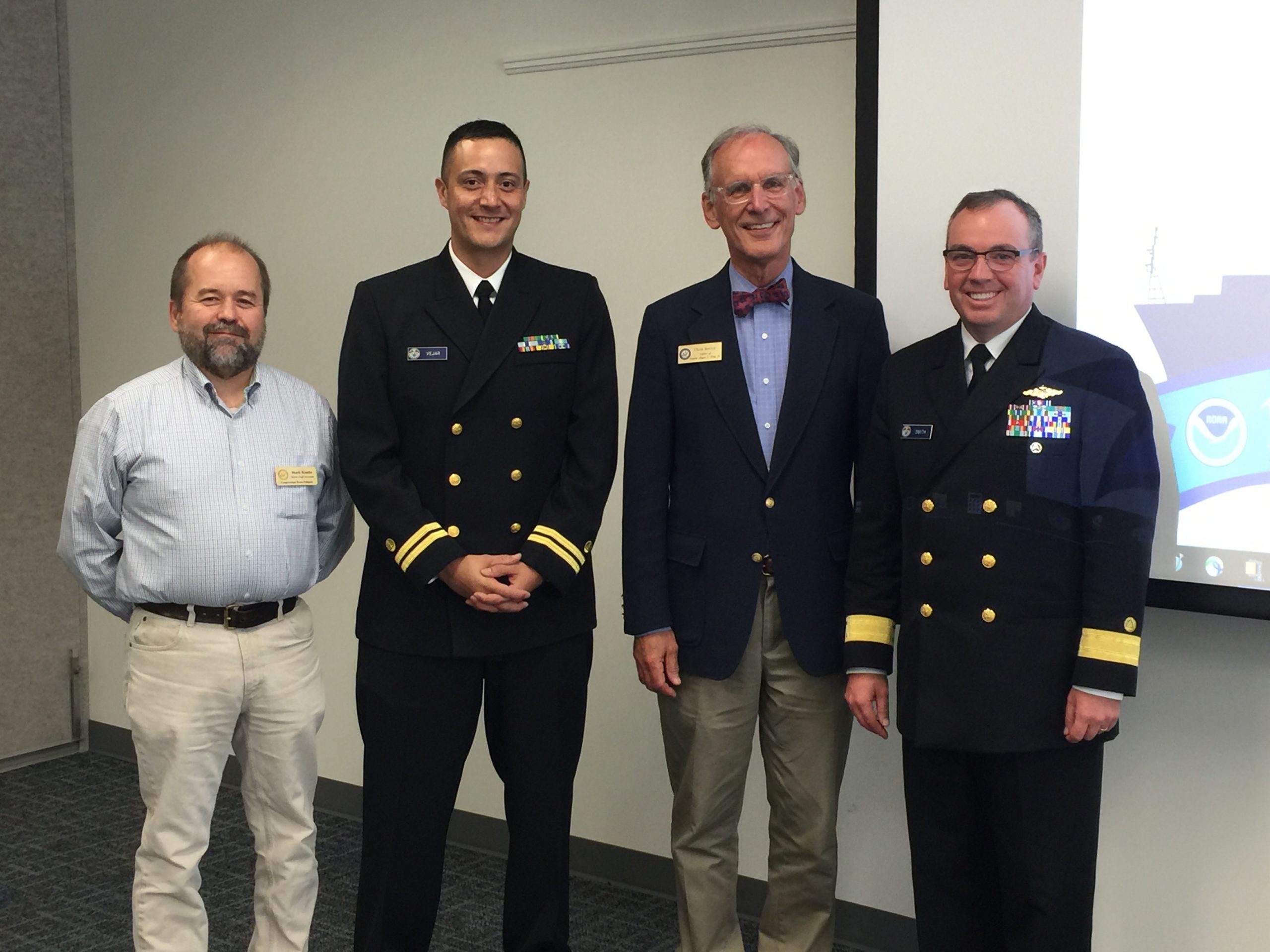
Recently, NOAA’s Office of Coast Survey hosted two stakeholder events in Belfast, Maine, to engage the local community on various NOAA products and updates in the region. Originally from Belfast himself, Rear Adm. Smith, director of the Office of Coast Survey, provided a warm introduction to both events. Dean Moyles, of Fugro, a NOAA hydrographic contractor, presented a summary of the hydrographic survey work being performed in Penobscot Bay. Lt. David Vejar, NOAA northeast navigation manager, highlighted various products and services, including how to access NOAA charts and data, the upcoming Gulf of Maine Operation Forecast System, nowCOAST, and various planning tools such as SeaSketch and Northeast Data Portal. Allison Wittrock, from Marine Charts Division, presented the National Charting Plan with a focus on how it will provide great benefit to stakeholders.
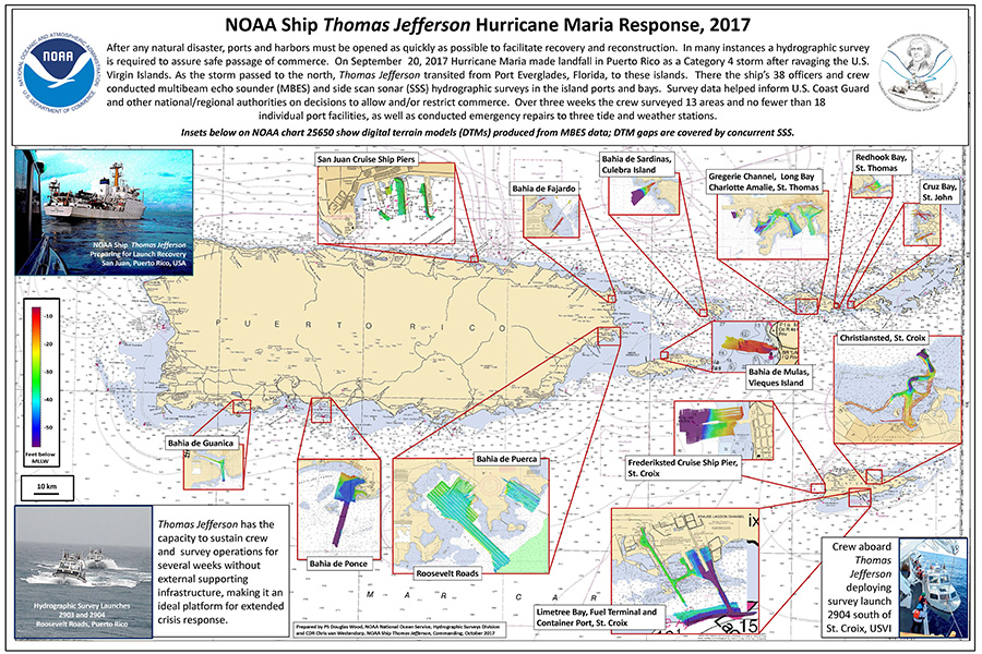
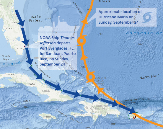
NOAA Ship Thomas Jefferson spent the last three weeks in Puerto Rico and the U.S. Virgin Islands surveying ports and bays in response to Hurricane Maria. Over the three week period, the crew surveyed 13 areas and no fewer than 18 individual port facilities, as well as conducted emergency repairs to three tide and weather stations. PS Doug Wood from Coast Survey’s Hydrographic Surveys Division and Cmdr. Chris van Westendorp, commanding officer of NOAA Ship Thomas Jefferson, compiled a poster highlighting all of the areas surveyed.
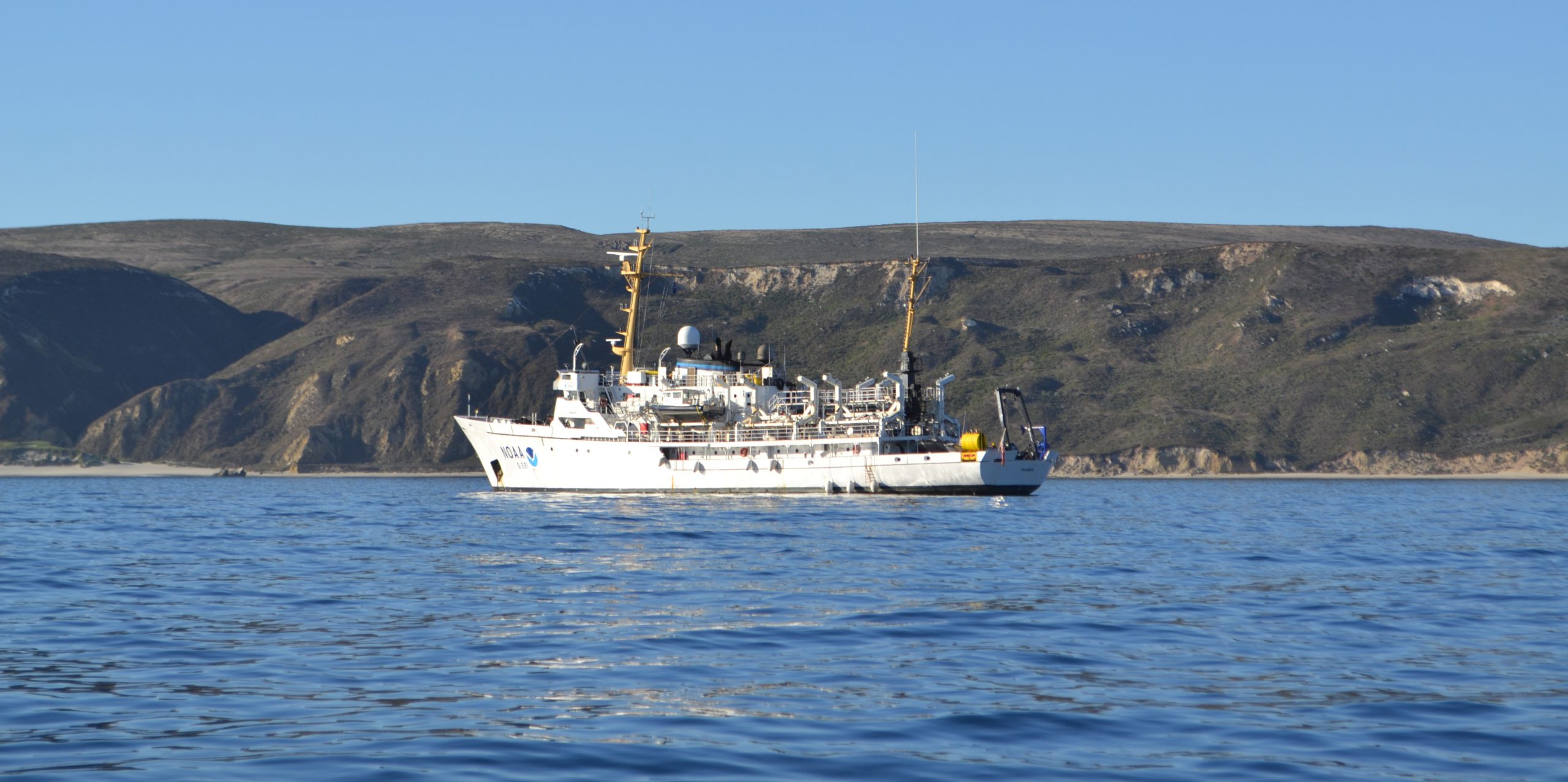
NOAA Ship Rainier recently arrived off the Santa Barbara coast to complete hydrographic surveys at NOAA’s Channel Islands National Marine Sanctuary (CINMS) as part of the Southern California Seafloor Mapping Initiative. Over the next month, the ship will use their new multibeam echo sounders to support safe navigation and update nautical charts for the sanctuary. In addition to providing data for crucial nautical chart updates, the surveys will also generate backscatter imagery, which the sanctuary uses for habitat mapping.
With news of Hurricane Maria’s devastating effects on the infrastructure of Puerto Rico, NOAA Ship Thomas Jefferson—originally scheduled to survey the approaches to the ports of Houston and Galveston following Hurricane Harvey—changed course. It was evident with the widespread flooding, winds, and storm surge that critical ports were paralyzed, and large ships with fuel and supplies were prevented from entering safely.
Coast Survey first sent NOAA’s mobile integrated survey team (MIST)—a mobile, quick-install side scan / single beam sonar kit that can be quickly set up on a vessel of opportunity—immediately following the storm at the request of the U.S. Coast Guard. MIST completed the emergency hydrographic surveys in the Port of Arecibo, an important fuel and chemical port. However, there is much more work to be done both immediately and in the long-term.
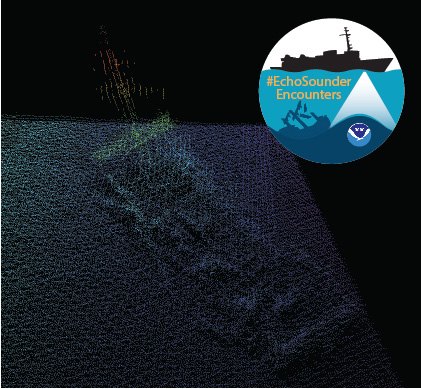
In late spring, while surveying off the coast of Long Island in Kodiak, Alaska, NOAA Ship Rainier found an uncharted shipwreck. Although rocks around the shipwreck were previously charted, this sunken vessel is a new feature. What made the find unique was how the top of wreck’s mast resembled a yellow light at the water’s surface. The Rainier crew fondly nicknamed it “ET’s finger.”
Mast of the sunken vessel found during the survey of Kodiak Island, AK, OPR-P136-RA-17. It was discovered by HAST Michael Bloom while on the NOAA Ship Rainier, in May 2017.
During the survey, Rainier was able to sail close enough to get multibeam echo sounder data over the shipwreck and record a shoal depth.
Multibeam echo sounder data depicting the shipwreck found off the coast of Long Island in Kodiak, Alaska.
Long Island was once the home ofFort Tidball, a World War II coastal fort established in 1941 and abandoned in 1946. NOAA received permission from the Alaska State Historic Preservation Office to share information about this shipwreck and is currently working to identify the ship.
Why is NOAA surveying around Kodiak Island? The area of Chiniak Bay supports the second busiest and third richest fisheries port in Alaska. In 2015, the Port of Kodiak was responsible for 514 million pounds of fish and $138 million of product. Chiniak Bay is the gateway to Kodiak and has a survey vintage of 1933. This area has seen many groundings and near misses due to the number of dangers to navigation and pinnacles that exist in this area. The navigation of this area is further complicated by the number vessels trying to enter and exit the Port of Kodiak via a choke point located at the channel entrance buoy. In recent years, a number of groundings in and around the area have occurred, the most famous being a 174-foot Army landing craft that was outbound to deliver goods to a remote village in western Alaska in 2012.
As the nation’s nautical chartmaker, NOAA Office of Coast survey serves a wide range of customers ranging from recreational boaters and operators of cargo ships, to historical chart enthusiasts. Customers throughout the world send us questions, comments, and also chart discrepancy reports, letting us know they found an error on a chart. As the Coast Survey “Answer Man,” I manage this communication, including Coast Survey’s response. Customers submit inquiries through our Inquiry and Discrepancy Management System (IDMS) database.
Hurricane Maria struck the U.S. Virgin Islands (USVI) and Puerto Rico on Wednesday, September 21, as a strong Category 4 hurricane. The storm brought sustained winds of 150 mph and dropped over 18 inches of rain in some areas. Although these islands have seen their fair share of hurricanes and tropical storms, the last storm of this intensity to hit Puerto Rico was the San Felipe Segundo hurricane in 1928. The widespread flooding, winds, and storm surge from Hurricane Maria devastated the islands leaving them without power and their critical ports paralyzed as debris, shoaling, and damaged infrastructure prevents large vessels from entering safely.