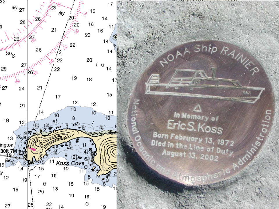
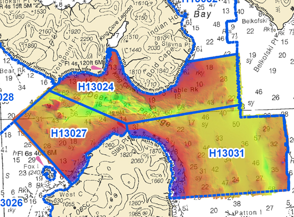
NOAA Ship Rainier has been diligently surveying Deer Passage in the vicinity of Cold Bay and King Cove, Alaska, for the past month.
This navigationally significant area between Unga Strait and Sanak Island provides the only protected route for vessels transiting between the Gulf of Alaska, the very busy Unimak Passage, and the Bering Sea beyond. Deer Passage is heavily trafficked by fishing vessels, coastal freight traffic, and Alaska Marine Highway System ferries, and serves as an alternate route for deep-draft vessels on Trans-Pacific routes between North America and Asia. While in the area, Rainier observed particularly heavy use of the waterway by vessels engaged in local and Bering Sea fisheries, and towing vessels supporting remote Alaskan communities with barge service.
Continue reading “NOAA Ship Rainier concludes it’s 2017 survey of Deer Passage, Alaska”
NOAA helps ports recover in Georgia and Florida following Hurricane Irma
Just as Hurricane Harvey response was wrapping up for some of NOAA Coast Survey’s navigation response teams (NRT), personnel and survey assets were positioned in preparation for the aftermath of Hurricane Irma.
For the NRTs, this meant traveling hundreds of miles with a survey vessel in tow, facing challenges such as locating fueling stations, finding available lodging, and finding opportunities to rest. For the mobile integrated survey team (MIST), which is available to travel anywhere in the U.S. when hydrographic survey assistance is needed by the U.S. Coast Guard (USCG) or U.S. Army Corps of Engineers (USACE), this meant finding transportation to a disaster area and a “vessel of opportunity” to survey from once there. Continue reading “NOAA helps ports recover in Georgia and Florida following Hurricane Irma”
NOAA positions personnel and survey assets in preparation for Hurricane Irma
As Hurricane Irma approaches Puerto Rico as a Category 5 storm, NOAA is positioning personnel and hydrographic survey assets to help speed the resumption of shipping post storm. In the wake of a hurricane, NOAA’s personnel and survey assets provide essential information when ports need to quickly but safely re-open, limiting significant economic losses caused by prolonged disruptions to the maritime transportation system. Continue reading “NOAA positions personnel and survey assets in preparation for Hurricane Irma”
NOAA helps ports recover from Hurricane Harvey
Hurricane Harvey is the first major hurricane of the 2017 Atlantic hurricane season. Harvey strengthened to a Category 4 reaching landfall along the Texas coast on Friday, August 25, at peak intensity. By the next day, the storm weakened to a tropical storm bringing torrential rainfall to the region. Continue reading “NOAA helps ports recover from Hurricane Harvey”
NOAA Ship Fairweather in western Alaska: A season of searching and survey
By ENS Linda Junge
NOAA Ship Fairweather has been busy during the last couple months. Three major activities have broken up the peak summer months of this field season.
Continue reading “NOAA Ship Fairweather in western Alaska: A season of searching and survey”Fifteen years later: Remembering a beloved crew member
The date, August 13, 2002, stands out in the memory of many Coast Survey employees, but most poignantly for the crew of NOAA Ship Rainier. It was this day in Prince William Sound, Alaska, when NOAA Ship Rainier’s survey launch capsized after being struck by high waves, killing Eric Koss, one of their beloved crewman and coxswain. The small launch was conducting nearshore surveys off Point Elrington in Prince William Sound. The seas were rough, but typical for the area. When the launch capsized, two of the crew members, David Fischman and NOAA Corps Ensign Jennifer Johnson, swam to safety, but Eric perished in the accident. Continue reading “Fifteen years later: Remembering a beloved crew member”
NOAA participates in the Boy Scouts of America National Jamboree
The U.S. Coast Guard (USCG) invited NOAA to participate in a joint task force at the Boy Scouts of America National Jamboree. Volunteer representatives from USCG active and reserve, USCG Auxiliary, USCG civilian workforce, and NOAA Corps created a large-scale exhibit to inform young men, young women, and adult leaders about the services that USCG and NOAA provide to the nation. Continue reading “NOAA participates in the Boy Scouts of America National Jamboree”
NOAA Ship Rainier holds change of command ceremony
by ENS Michelle Levano
On July 22, 2017, the crew of NOAA Ship Rainier hosted a change of command while at United States Coast Guard Base Kodiak, Alaska.
Commander Benjamin Evans accepted command of Rainier, relieving Commander John Lomnicky in a ceremony led by Captain Keith Roberts, commanding officer of NOAA’s Office of Marine and Aviation Operations (OMAO) Marine Operations Center-Pacific. Distinguished guests included Captain Richard Brennan, chief of NOAA Office of Coast Survey’s Hydrographic Surveys Division, Mr. Greg Kaplan, Military and Veterans Affairs liaison for Senator Lisa Murkowski, Captain Jeffery Good, commanding officer United States Coast Guard (USCG) Base Kodiak, Commander Michael Levine, commanding officer of NOAA Ship Oscar Dyson, and Commander Daniel Rogers, executive officer of United States Coast Guard Base Kodiak. Continue reading “NOAA Ship Rainier holds change of command ceremony”
NOAA hosts third annual workshop on nautical chart adequacy
This week, NOAA’s Office of Coast Survey hosted its third annual workshop on nautical chart adequacy. Twelve students participated in the training and learned techniques to evaluate the suitability of nautical chart products using chart quality and publicly available information. This year’s workshop emphasized cartography and the ability to transfer NOAA procedures to the students’ charting products. The workshop provided a theoretical background on:
- Chart production at NOAA
- Review of NOAA charted symbols and abbreviations
- Review of automatic identification systems (AIS) and satellite-derived bathymetry (SDB)
- Overview of the chart adequacy procedure
Continue reading “NOAA hosts third annual workshop on nautical chart adequacy”
Rear Adm. Shepard M. Smith elected to chair the International Hydrographic Organization Council
Rear Adm. Shepard M. Smith, director of NOAA’s Office of Coast Survey and the U.S. national representative to the International Hydrographic Organization (IHO), was elected as the chair of the newly established IHO Council.
The council was established in November 2016 as a result of the adoption of amendments to the Convention on the International Hydrographic Organization. It is composed of 30 leading hydrographic nations from the membership of the IHO, and functions much like a corporate board of directors, overseeing performance management and the business side of the IHO. Continue reading “Rear Adm. Shepard M. Smith elected to chair the International Hydrographic Organization Council”
