Navigating waters before GPS: Why some mariners still refer to Loran-C

by Nick Perugini
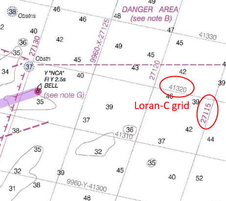
One of the most popular recurring questions received by NOAA’s Office of Coast Survey involves customers – typically fishermen – wanting to obtain a chart with a Loran-C navigation grid on it. Here are a few inquiries from NOAA’s Nautical Inquiry & Comment System:

  • Hello, I was wondering if it is still possible to purchase or locate older editions of Lake Huron charts (14862-3-4) with the LORAN-C overlay. Many older wrecks and reported snags are still in Loran and have not been converted to GPS. Artificial algorithms are difficult to use when plotting grids. Any help you can give me is much appreciated.
  • Is it possible to access Loran-C charts of New England from prior to 2009 when NOAA stopped published with the LORAN-C lines? THANKS!
  • I was wondering if there was a way for me to buy a chart that has LORAN lines and notes on it? I understand that all of the new charts no longer have this information on them. I am most interested in Chart 11520, Cape Hatteras to Charleston. I didn’t know if there might be an archived form of this chart that shows the LORAN features. Any help in finding a chart like this would be greatly appreciated.

Continue reading “Navigating waters before GPS: Why some mariners still refer to Loran-C”

Online NOAA Custom Chart lets boaters create their own charts

NOAA Custom Chart makes it easy for users to create a personalized chart.

A prototype version of a powerful new online tool, NOAA Custom Chart, is now available for boaters and other nautical chart users. The application enables users to define the scale and paper size of custom-made nautical charts centered on a position of their choosing. Once the functionality of this prototype is fully developed, NOAA Custom Chart will be an easy way for boaters to create a paper or digital back-up for the electronic chart system or other GPS-enabled chart display that they are using on board.
Continue reading “Online NOAA Custom Chart lets boaters create their own charts”

NOAA mobile integrated survey team prepares for hurricane season

NOAA’s Office of Coast Survey is the federal leader in emergency hydrographic response. Consecutive strong storms during the 2017 hurricane season made response efforts challenging, and emphasized the importance of having a well-trained and versatile staff. Coast Survey’s regional navigation managers, navigation response teams (NRTs), and mobile integrated survey team (MIST) worked with partners before and after the storms to quickly and safely reopen ports and waterways.
The MIST equipment is a mobile, quick-install side scan and single beam sonar kit that can be quickly set up on a vessel of opportunity. Recently, Coast Survey sent the MIST team to Astoria, Oregon to conduct a hydrographic survey of the Mott Basin area, which the U.S. Coast Guard (USCG) requested to confirm charted depth and obstruction data. Continue reading “NOAA mobile integrated survey team prepares for hurricane season”

NOAA navigation response team investigates hazardous shoal off Rockaway Point, NY

Recently, NOAA navigation response team 5 (NRT5), responded to a survey request from U.S. Coast Guard (USCG) Sector New York following several groundings near Rockaway Point in Queens, New York. Waves and currents often influence the size and shape of nearshore sandbars, and the USCG was concerned that a sandbar may have expanded beyond the area depicted on the nautical chart. Lt. j.g. Dylan Kosten, Eli Smith, and Michael Bloom traveled from New London, Connecticut, to Jersey City, New Jersey, to launch their vessel and start the survey of the area.
Continue reading “NOAA navigation response team investigates hazardous shoal off Rockaway Point, NY”

NOAA ships Fairweather and Rainier mark 50 years of service and survey

NOAA ships Rainier and Fairweather.

To recognize the successful history of NOAA ships Fairweather and Rainier, as well as the professional mariners, hydrographers, and commissioned officers who have served aboard these ships for the last 50 years, NOAA hosted a ceremony and public ship tours at the Marine Operations Center – Pacific (MOC-P) in Newport, Oregon.

Continue reading “NOAA ships Fairweather and Rainier mark 50 years of service and survey”

NOAA quickly updates nautical chart, allowing large ships to dock with confidence in Port Everglades

Change in the slip length reflected in ENC cell US5FL32 and US4FL31.

NOAA’s Office of Coast Survey quickly updated NOAA electronic navigational charts (NOAA ENC®) to accurately reflect the 225 foot expansion of a slip in Port Everglades, Florida. Now at a total length of 1,125 feet, the elongated slip allows larger ships to dock with confidence. The Port Everglades Pilots – maritime pilots who maneuver ships through crowded harbors and confined waters – requested the chart update. With ENCs that accurately reflect the slip expansion in their hands, pilots can easily communicate to vessel captains that it is safe to dock their vessels in the slip.
Port Everglades is one of the top three cruise ports in the world, and is among the most active cargo ports in the United States. Every slip is kept in high use, and Coast Survey used a new data process that allowed the most critical and valuable information to be applied quickly and made available to the end user. Continue reading “NOAA quickly updates nautical chart, allowing large ships to dock with confidence in Port Everglades”

NOAA navigation response team locates sunken vessel before nor’easter strikes

Multibeam Imagery of the vessel

On March 12, 2018, NOAA Coast Survey’s navigation response team 5 (NRT5) located the T/V Captain Mackintire, an 80-foot towing vessel that sank off the coast of Kennebunkport, Maine. The U.S. Coast Guard requested assistance finding the vessel, citing concerns of environmental hazards due to an unknown amount of fuel remaining onboard.

Continue reading “NOAA navigation response team locates sunken vessel before nor’easter strikes”

Take a 360 tour of NOAA Ship RAINIER

In celebration of 50 years of survey and service to the nation, NOAA ships Rainier and Fairweather—two of NOAA’s hydrographic survey vessels—will be opening their doors and hosting public ship tours. Since we understand that many of you are unable to be in Newport, Oregon, the afternoon of March 22 to take a tour in person, we are bringing the tour to you! The following 20 images offer a 360 degree view of the interior and exterior of NOAA Ship Rainier. The images were taken last field season on the survey operations mission to Channel Islands, California. From the crew mess and engine room to a view from the bow, we have captured it all.
Continue reading “Take a 360 tour of NOAA Ship RAINIER”

NOAA RNC Tile Service displays first ENC-only product

The Merrimack River, located in Massachusetts, is just south of the New Hampshire border.The single chart tile set is named​ 13274K0000_1.

NOAA Office of Coast Survey released its 1:12,000 electronic navigational chart (NOAA ENC®of the Merrimack River, Massachusetts, in the RNC Tile Service. This is the first time a navigational chart—created solely as ENC product—is included in the tile service. The tile service renders a traditional depiction of the nautical chart for use with GPS-enabled electronic chart systems or other “chart plotter” display systems to provide real-time vessel positioning for recreational mariners. This chart is included in the single chart tile sets and the quilted tile sets both in the online and offline versions. Continue reading “NOAA RNC Tile Service displays first ENC-only product”