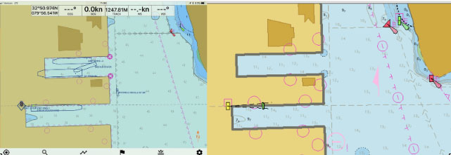
NOAA’s Office of Coast Survey quickly updated NOAA electronic navigational charts (NOAA ENC®) to accurately reflect the 225 foot expansion of a slip in Port Everglades, Florida. Now at a total length of 1,125 feet, the elongated slip allows larger ships to dock with confidence. The Port Everglades Pilots – maritime pilots who maneuver ships through crowded harbors and confined waters – requested the chart update. With ENCs that accurately reflect the slip expansion in their hands, pilots can easily communicate to vessel captains that it is safe to dock their vessels in the slip.
Port Everglades is one of the top three cruise ports in the world, and is among the most active cargo ports in the United States. Every slip is kept in high use, and Coast Survey used a new data process that allowed the most critical and valuable information to be applied quickly and made available to the end user.
To update nautical charts, Coast Survey historically applied data that covered the entire shoreline. This process was cumbersome and time-consuming as updates were based on a print (not digital) cycle. However, in this case, Coast Survey utilized discrete shoreline snippets of the target areas, provided by National Geodetic Survey’s Remote Sensing Division (RSD), to ensure a quick turnaround of the corrected charts.

Harbor bathymetric survey data from the U.S. Army Corps of Engineers and shoreline revision data from a georeferenced WorldView-2 image, compiled by the RSD, were used to update the harbor (1:10,000) and approach (1:80,000) ENC charts. This ENC-first, digital structure as outlined in the National Charting Plan helps Coast Survey quickly apply updates to charts, increase efficiency, and streamline data workflows.

News and Updates