New private hydro vessel adds to nation’s capabilities

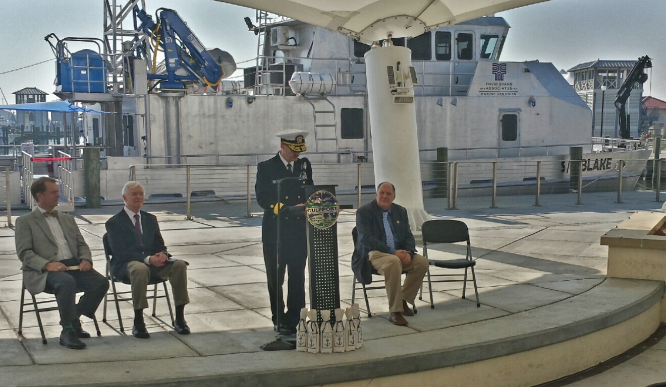
Under beautiful blue skies yesterday in Gulfport, Mississippi, David Evans and Associates, Inc. commissioned its new 82-foot hydrographic survey and scientific vessel Blake. Rear Admiral Gerd Glang, Coast Survey’s director, welcomed the addition to the nation’s hydrographic surveying assets. DEA is under contract to NOAA to provide critical hydrographic data for updating the nation’s nautical charts.
Continue reading “New private hydro vessel adds to nation’s capabilities”

Survey helps ensure safe “parking” for deep-draft vessel in SF

In preparation for the M/V TERN’s anticipated arrival this week in San Francisco Bay, the Coast Guard and Port of San Francisco asked Coast Survey for a bathymetric survey of the proposed anchorage site. TERN is a semi-submersible vessel with a 60-foot draft, and the proposed anchorage site has charted depths of 62 feet and 63 feet ‒ leaving no room for error, to say the least. The question was whether there are any spots shoaler than 62 feet.
This isn’t your everyday anchorage.
Continue reading “Survey helps ensure safe “parking” for deep-draft vessel in SF”

NOAA is open for business with navigation industry

At the first NOAA Navigation Industry Day, held October 10 in conjunction with the Annapolis Boat Show, over two dozen of the world’s top maritime app and navigation system developers met with NOAA experts to learn more about the vast amounts of NOAA data that is available for free access and use.

IT charting specialist Pete Gomez explains how Coast Survey is developing a new chart tile service, to be unveiled this winter.

Continue reading “NOAA is open for business with navigation industry”

NOAA Ship Thomas Jefferson celebrates survey success with maritime community

NOAA Ship Thomas Jefferson

by Ensign Diane Perry, onboard NOAA Ship Thomas Jefferson
From 2005 through today, NOAA Ship Thomas Jefferson has been surveying Long Island Sound, one project area at a time. Some of the area was last surveyed between the late 1800s and 1939. For the 2014 field season, Thomas Jefferson was assigned her final Long Island Sound project, 89 square nautical miles of Eastern Long Island Sound, Fisher Island Sound, and Western Block Island Sound. When this project is complete, we will have resurveyed over 95% of Long Island Sound and all of Block Island Sound with modern survey technology that allows for a complete picture of the seafloor and highly accurate soundings.

This image depicts Thomas Jefferson's bathymetry from eastern Long Island Sound to Gardiner's Bay.
This image depicts Thomas Jefferson‘s bathymetry from eastern Long Island Sound to Gardiner’s Bay.

Continue reading “NOAA Ship Thomas Jefferson celebrates survey success with maritime community”

A “soft” resilience strategy is part of successful hurricane response

We hear about the infrastructure investments that often follow major disasters like hurricanes ‒ the “hard” port resilience strategies necessary in the wake of catastrophic human, environmental, and economic loss. But the sturdiest, most flood-proof building is just one part of a larger system of assets in coastal resilience. We don’t hear much about the “soft” resilience strategies ‒ those that build and maintain ties among the people responsible for responding to a hurricane, for instance ‒ that are important to a successful response. Those strategies are part of the social capital between communities and government, and among government agencies.

Coast Survey's Capt. Jon Swallow and Rear Adm. Gerd Glang review charting and survey requirements with Capt. Andrew Melick of of the Biscayne Bay Pilots Association.
Coast Survey’s Capt. Jon Swallow and Rear Adm. Gerd Glang meet with Capt. Andrew Melick of of the Biscayne Bay Pilots Association.

Continue reading “A “soft” resilience strategy is part of successful hurricane response”