NOAA preserves history of Washington, DC, with reproduced L’Enfant maps

This copper plate, named No. 3043 PRICE 45 CENTS, is one of the 3000 series of special products produced by Coast Survey’s predecessor, the Coast and Geodetic Survey. The Coast and Geodetic Survey primarily made nautical charts, but a number of maps in the 3000 series were instead maps of some thematic factor of interest (i.e., the Slaver Map, No. 3033; Glacier Bay, Alaska, No. 3095).

By Capt. Albert “Skip” Theberge (NOAA, ret.)

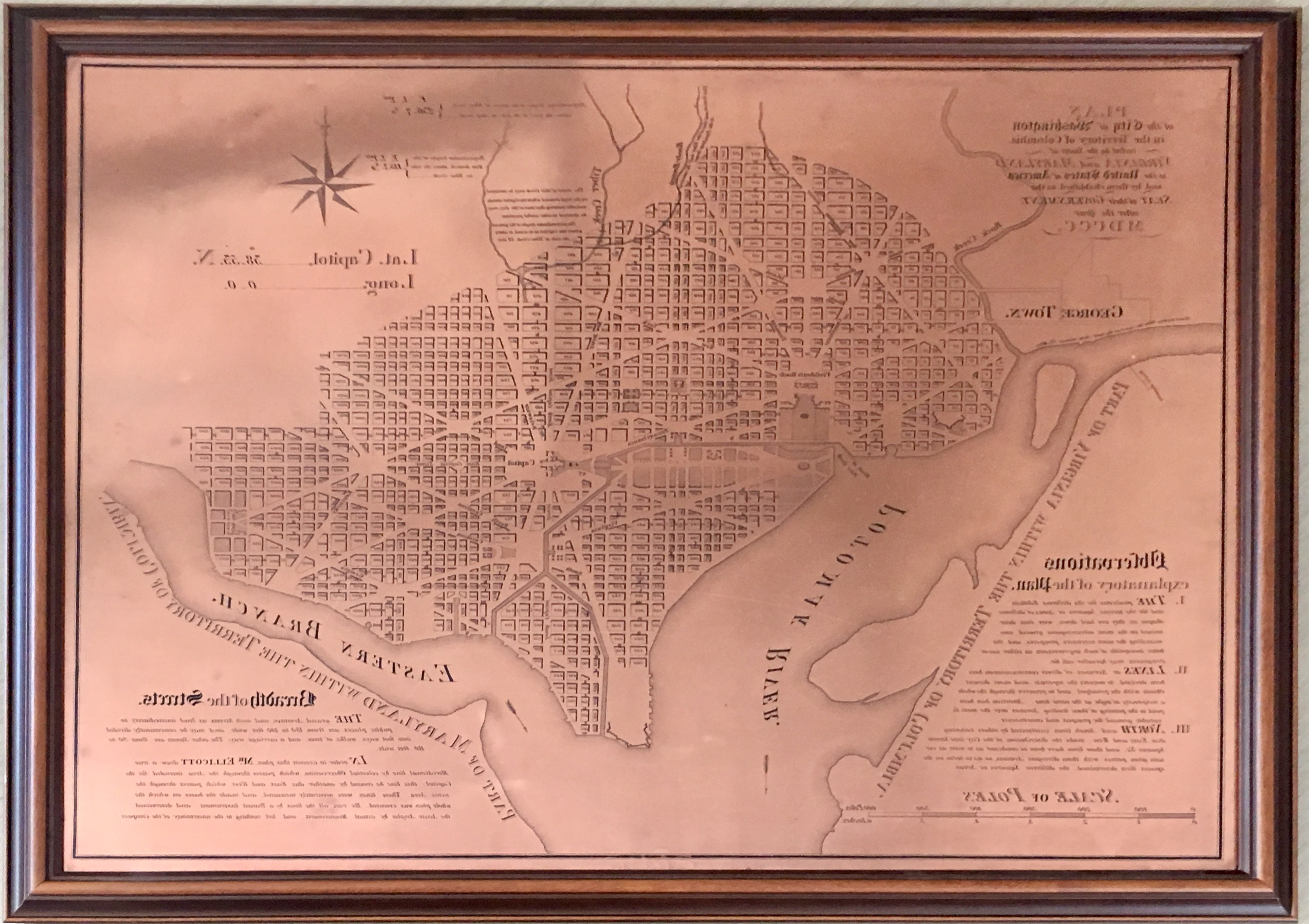
Research conducted by the NOAA Central Library uncovered a little known fact that NOAA Coast Survey’s skill in reproducing maps helped ensure that early maps of Washington, DC, and an interesting piece of history, weren’t lost. Coast Survey reproduced three historically significant maps from a copper plate engraving of Washington, DC, as surveyed by Pierre L’Enfant and Andrew Ellicott.
Continue reading “NOAA preserves history of Washington, DC, with reproduced L’Enfant maps”

Seismic inter-agency collaborations on NOAA Ship Rainier

Rainier crew practice deploying the Edgetech Sub-bottom 512 Chirp profiler

By Ensign Airlie Pickett, NOAA

NOAA Ship Rainier spent September completing a multi-leg, joint collaboration project investigating deep offshore areas of the southern California coast. The U.S. Geological Survey (USGS) and Bureau of Ocean Energy Management (BOEM) partnered with NOAA to support a month-long mission to collect geophysical data along the outer continental shelf of California where the area in question features a number of different geologic structures and processes. Continue reading “Seismic inter-agency collaborations on NOAA Ship Rainier”

NOAA Ship Thomas Jefferson successfully tests new wireless system that aids remote vessel operation

By Lt. Charles Wisotzkey, NOAA

NOAA Ship Thomas Jefferson successfully tested a new wireless networking system while working in the Approaches to Houston/Galveston and around Puerto Rico during the 2018 field season. This new system connects the ship and its two hydrographic survey launches, providing a level of wireless connectivity previously unobtainable with traditional wireless communications systems. NOAA anticipates this will increase unmanned system productivity while conducting hydrographic surveys. Continue reading “NOAA Ship Thomas Jefferson successfully tests new wireless system that aids remote vessel operation”

NOAA detects navigation hazards following Hurricane Michael

sunken vessel with navigation response team vessel in foreground

After quickly gaining the strength of a Category 4 storm, Hurricane Michael reached the panhandle of Florida on Wednesday, October 10. With maximum sustained winds of 155 mph and storm surge reaching 15 feet, this storm wiped out coastal communities and closed ports to all traffic in the area. Dangerous winds and storm surge can shift sands and pull large objects beneath the waves, creating hazards to navigation. Before ports can reopen and safely resume vessel traffic, the U.S. Coast Guard must be aware of any underwater dangers so they can either be properly charted or removed. Continue reading “NOAA detects navigation hazards following Hurricane Michael”

NOAA and USGS collaborate to fulfill important agency missions in offshore areas along the West Coast

This summer, the Coastal and Marine Geology Program of the U.S. Geological Survey (USGS) and NOAA’s Office of Coast Survey together ran an interagency ocean mapping project across several large portions of the Cascadia Margin, offshore of California, Oregon, and Washington states.
This collaboration,  conducted aboard the NOAA Ship Rainier, used hydrographic surveying equipment to collect swath bathymetry, backscatter intensity data, and full water column data within the project areas. The high-resolution geospatial data acquired will provide key baseline data for targeted USGS studies to improve hazard assessment and forecasting for marine geohazards offshore of northern California, Oregon, and Washington.  NOAA will also use the data to update nautical charts for safe navigation in the region. Continue reading “NOAA and USGS collaborate to fulfill important agency missions in offshore areas along the West Coast”