This summer, the Coastal and Marine Geology Program of the U.S. Geological Survey (USGS) and NOAA’s Office of Coast Survey together ran an interagency ocean mapping project across several large portions of the Cascadia Margin, offshore of California, Oregon, and Washington states.
This collaboration, conducted aboard the NOAA Ship Rainier, used hydrographic surveying equipment to collect swath bathymetry, backscatter intensity data, and full water column data within the project areas. The high-resolution geospatial data acquired will provide key baseline data for targeted USGS studies to improve hazard assessment and forecasting for marine geohazards offshore of northern California, Oregon, and Washington. NOAA will also use the data to update nautical charts for safe navigation in the region.

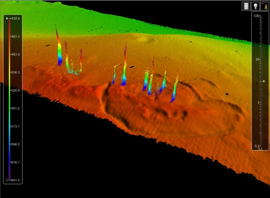
High-resolution multibeam and backscatter imagery will allow identification and characterization of active faults and submarine landslides. These data, combined with detailed sub-seafloor imagery and geologic sampling, will provide information on the relative timing and rate of deformation of these features, which is imperative for earthquake and tsunami hazard assessment. The seafloor imagery will also provide an important pre-event bathymetric baseline for assessment of seafloor deformation after future large earthquakes. Water column data were also utilized to expand the mapping of seafloor seep distribution, which is key for understanding the relationship between fluid plumbing and seafloor failure and seismogenesis along the Cascadia Margin.


This project epitomizes NOAA’s Integrated Ocean and Coastal Mapping mantra, “map once, use many times,” to support coastal and ocean management activities and marine navigational safety. Much of the existing data in the area dates back to the 1930s and was acquired via lead line or single beam survey technology. The collaboration is also part of the Expanding Pacific Research and Exploration of Submerged Systems campaign, comprised of a large and diverse team of federal and non-federal partners targeting deepwater areas off of the U.S. Pacific coast.

Nautical charts that will be updated include: 18500, 18520, 18580, 18600, 18620, 18003 and 18010 with corresponding electronic navigational charts (NOAA ENC®) US3WA03M and US3OR01M, US3ORO2M, US3ORO3M, US3CA15M, US5CA95M and US5OR51M. In addition, applicable sections from NOAA’s U.S. Coast Pilot® Book 7 (50th Edition, 2018) will also be updated.
Collaboration between NOAA and the USGS on this Cascadia Margin project allows each agency to efficiently leverage resources, and to benefit from complementary expertise within the other agency. NOAA and USGS both fulfilled important mission priorities by combining NOAA vessels and expertise in state-of-the-art acoustic data acquisition with USGS prowess in detecting and characterizing marine geohazard sources such as faults, tsunami potential and submarine landslides.

News and Updates