
By Lt. Charles Wisotzkey, NOAA
NOAA Ship Thomas Jefferson successfully tested a new wireless networking system while working in the Approaches to Houston/Galveston and around Puerto Rico during the 2018 field season. This new system connects the ship and its two hydrographic survey launches, providing a level of wireless connectivity previously unobtainable with traditional wireless communications systems. NOAA anticipates this will increase unmanned system productivity while conducting hydrographic surveys.
For over a decade, NOAA has explored how autonomous systems provide more efficient and effective acquisition of environmental data. Developing the capabilities for productive autonomous systems has been an iterative process for NOAA. From fielding Teledyne Z-Boats off Thomas Jefferson — to collaborating with UNH CCOM/JHC on the deployment of an autonomous survey platform from NOAA Ship Fairweather — to installing equipment on survey launches to operate them remotely or autonomously — NOAA is inching closer to fully operationalizing autonomous systems. Today, Thomas Jefferson continues the tradition of collaborative and bottom-up innovation by improving network connectivity and data telemetry between the ship and its launches, demonstrating their ability to operate launch systems remotely.
Overview of the data radio system
The new system on Thomas Jefferson provides Mobile Ad Hoc Networking (MANET) — a type of wireless mesh network — connectivity between the ship and its launches. The use of a mesh network topology means that all nodes in the data network can communicate and route network traffic to all other nodes. The MANET design results in a dynamic network structure (i.e. mobile, ad-hoc, and self-forming in nature) and is essentially without infrastructure (i.e. all nodes communicate via wireless connection). This design is ideal for applications requiring network connectivity between ship and remote data acquisition platforms.


The system uses SC4200 radios manufactured by Silvus Technologies, Inc., providing small and rugged units that deploy in a variety of scenarios. For example, the radios deploy easily on small boats exposed to the elements, or even worn by individuals on a belt or harness. SC4200 radios use multiple antennas to provide advanced multiple-in-multiple-out beam-formed data streams, resulting in higher data throughputs at longer ranges. On Thomas Jefferson, three radios connect to three high gain sector antennas on the ship, while the launches use one radio and two omni-directional antennas each.
Initial testing and results
Initial testing assessed achievable throughput (usable bandwidth) between the ship and one launch; a concept of operations was also demonstrated for use of unmanned systems in operating environments such as the Gulf of Mexico. Initial testing was very promising with observed throughput at three to five nautical miles exceeding typical data collection rates for multibeam echo sounder survey operations. The system also performed well at ranges up to seven nautical miles (the extent of ship-launch separation for this test).

Testing and development continued while on project in Puerto Rico. In mid-August, Thomas Jefferson accomplished an important milestone when raw data from a launch working five nautical miles from the ship was transferred to the ship real-time. This remote broadband ability opens up new workflow possibilities and starts to address the problem of ‘data build up’ on unmanned systems that have long operational endurances.

Beyond testing and evaluation, the data radio systems provided immediate operational benefits, particularly remote observation, control, and troubleshooting of launch acquisition systems, making a field operations officer’s or chief hydrographic survey technician’s (HIC) life much easier! Another benefit is the ability to share sound velocity cast data across platforms. This feature proved especially useful when the ship’s moving vessel profiler system was inoperable while on project in the Gulf of Mexico and when multiple conductivity/temperature/depth (CTD) device malfunctions reduced stock to one working CTD to be shared between two launches while on project in Puerto Rico.
Thomas Jefferson demonstrates ability to operate launch systems remotely
Thomas Jefferson reached another major milestone when one of its remotely operated launches collected data on October 9. All survey systems were controlled from the ship acquisition station, all raw hydrographic data was automatically transferred to the ship as it was logged, and the launch was steered remotely from the ship.

A combination of pre-planned line files and on-the-fly line planning demonstrated remote control of launch steering systems. The autopilot followed standard survey lines, pre-planned “turn” polylines, and lines created as needed by the remote HIC in real-time. This last capability enabled the ship HIC to maneuver the launch in relatively complex ways, as well as acquire data over some holidays.

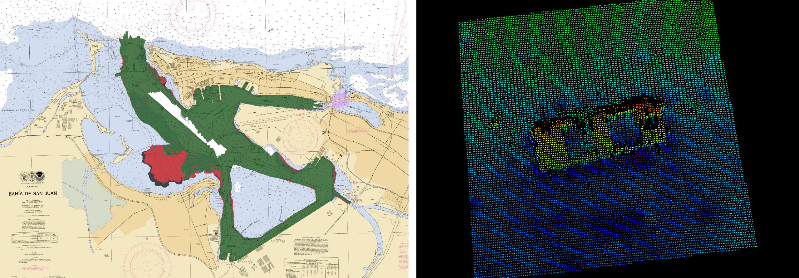
Data collected during the demonstration was equivalent in all regards to data collected during a traditional launch day and will be submitted as part of survey H13140. Thomas Jefferson even found a wreck during the first day of remote launch operations!

Future evaluation and development activities
The data radio system provides an environment for development of other key enabling capabilities, such as unmanned systems. Thomas Jefferson will focus on challenges both specific (e.g. system integration, moving data, generate operational metrics, etc.) and broad (e.g. ship-board IT infrastructure and administration policy integration with new capabilities and future operations) in nature. We especially look forward to working with partners to implement solutions that place NOAA at the forefront of the hydrographic community with respect to unmanned system hydrographic survey.
The command and crew aboard NOAA Ship Thomas Jefferson are grateful for assistance rendered thus far from Office of Marine and Aviation Operations (OMAO) IT, OMAO’s Marine Operations Electronics Engineering Branch, and Office of Coast Survey’s Hydrographic Systems and Technology Branch (notably PS Eric Younkin and Lt. j.g. Matt Sharr) in reaching these remote operation milestones.