NOAA researches autonomous survey system in the Arctic

The unmanned surface vehicle BEN launched from NOAA Ship Fairweather. Photo by Christina Belton, NOAA.

By Rob Downs, Office of Coast Survey unmanned systems projects lead

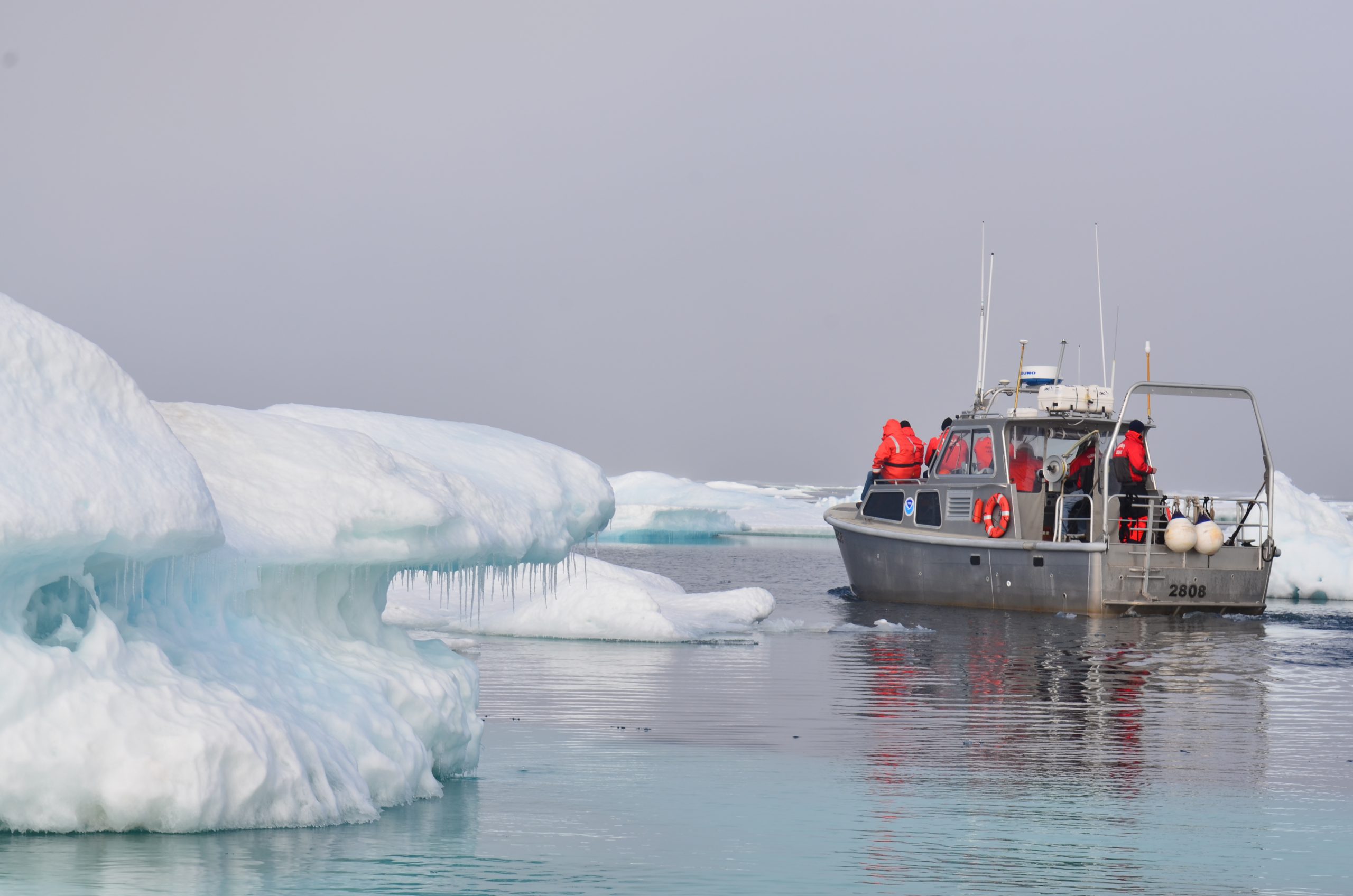
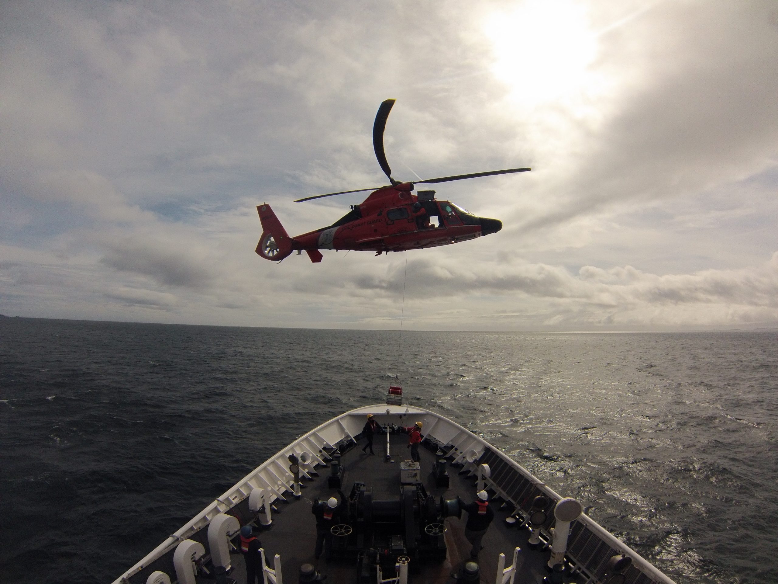
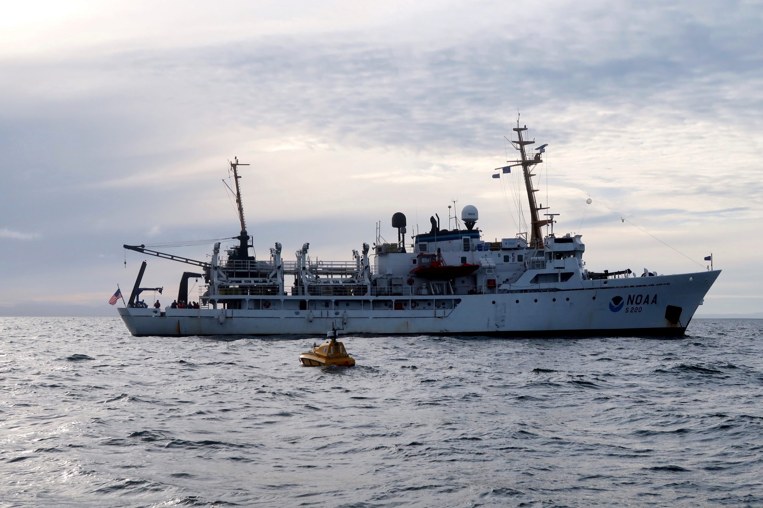
A team composed of research engineers and a graduate student from the University of New Hampshire Center for Coastal and Ocean Mapping/Joint Hydrographic Center (UNH CCOM/JHC) and personnel from NOAA’s Office of Coast Survey are aboard the NOAA Ship Fairweather to test UNH’s BEN (Bathymetric Explorer and Navigator) unmanned surface vehicle (USV). On Saturday, July 28, the Fairweather made the first successful launch of a USV for an operational hydrographic survey from a NOAA vessel in the Arctic. The team conducted four additional deployments, including an extended overnight survey made in coordination with the ship.

Continue reading “NOAA researches autonomous survey system in the Arctic”

NOAA surveys the unsurveyed, leading the way in the U.S. Arctic

President Thomas Jefferson, who founded Coast Survey in 1807, commissioned Lewis and Clark’s Corps of Discovery Expedition in 1803, the first American expedition to cross the western portion of the contiguous United States. Today there remains a vast western America territory that is largely unknown and unexplored – the U.S. waters off the coast of Alaska. As a leader in ocean mapping, NOAA Coast Survey launches hydrographic expeditions to discover what lies underneath the waves.

Alaska is one-fifth the size of the contiguous United States, and has more than 33,000 milesof shoreline. In fact, the Alaskan coast comprises 57 percentof the United States’ navigationally significant waters and all of the United States’ Arctic territory. Alaskan and Arctic waters are largely unchartedwith modern surveys, and many areas that have soundings were surveyed using early lead line technology from the time of Capt. Cook, before the region was part of the United States. Currently only 4.1 percent of the U.S. maritime Arctic has been charted to modern international navigation standards.

Continue reading “NOAA surveys the unsurveyed, leading the way in the U.S. Arctic”

NOAA Ship Rainier concludes it’s 2017 survey of Deer Passage, Alaska

The total area surveyed by Rainier in the Cold Bay and King Cove Vicinity during the 2017 Field Season, complied by Hydrographic Senior Survey Technician Gahlinger.

NOAA Ship Rainier has been diligently surveying Deer Passage in the vicinity of Cold Bay and King Cove, Alaska, for the past month.

This navigationally significant area between Unga Strait and Sanak Island provides the only protected route for vessels transiting between the Gulf of Alaska, the very busy Unimak Passage, and the Bering Sea beyond. Deer Passage is heavily trafficked by fishing vessels, coastal freight traffic, and Alaska Marine Highway System ferries, and serves as an alternate route for deep-draft vessels on Trans-Pacific routes between North America and Asia. While in the area, Rainier observed particularly heavy use of the waterway by vessels engaged in local and Bering Sea fisheries, and towing vessels supporting remote Alaskan communities with barge service.

Continue reading “NOAA Ship Rainier concludes it’s 2017 survey of Deer Passage, Alaska”

Surveying, rescue drills, and an open house—NOAA Ship Rainier has been busy!

by ENS Michelle Levano

NOAA Ship Rainier continues hydrographic survey operations in Chiniak Bay, near Kodiak, Alaska. As of June 1, 2017, Rainier and her survey launches have surveyed 2,025 nautical miles in the Spruce Island, Long Island, Middle Bay, Kalsin Bay, Isthmus Bay, and offshore Cape Chiniak areas. The total distance surveyed is about as long as the Mississippi River.

Continue reading “Surveying, rescue drills, and an open house—NOAA Ship Rainier has been busy!”

NOAA Ship Fairweather uses new technology to improve survey efficiency

Area surveyed by Fairweather May 30- June 10, 2017.
By ENS Peter Siegenthaler

Following the scheduled winter repair period, Fairweather is kicking off the 2017 field season in Tlevak Strait; the waterway between Dall Island and Prince of Wales Island in Southeast Alaska. This area was last surveyed between 1900 and 1939, and the lead-lines used at the time to determine depths were susceptible to omission of rocks and other features in an area. Using the latest innovations in hydrographic technology, Fairweather will be resurveying these areas with complete coverage multibeam echo sounder bathymetry. This allows Fairweather to identify any rocks or shoal features missed in prior surveys, increasing the safety for local communities, whose economies and livelihoods are dependent on maritime transportation of goods.

Continue reading “NOAA Ship Fairweather uses new technology to improve survey efficiency”

NOAA Ship Rainier surveys the waters around Kodiak Island

by ENS Michelle Levano

Kodiak Island is the 2nd largest island in the United States; it is part of the Kodiak Island Archipelago, a group of islands roughly the size of Connecticut. Due to the island’s location in the Gulf of Alaska and North Pacific Ocean, Kodiak is ranked as third in commercial fishing ports in the U.S. in terms of value of seafood landed. In 2015, the Port of Kodiak was responsible for 514 million pounds of fish and $138 million of product. More than one-third of the jobs in Kodiak are related to the fishing industry.
The Port of Kodiak is home to more than 700 commercial fishing vessels, and has more than 650 boat slips and three commercial piers that can dock vessels up to 1,000 feet. In addition to fishing, Kodiak is the hub of the Gulf of Alaska container logistics system, serving the southwest Alaskan communities with consumer goods and outbound access to the world’s fish markets.

Continue reading “NOAA Ship Rainier surveys the waters around Kodiak Island”

Report from the Arctic: Surveying Kotzebue Sound 2015

By Starla Robinson, project manager in Coast Survey’s Hydrographic Surveys Division
Two hundred years after Otto von Kotzebue and the crew of the Ruiric explored what would later be named Kotzebue Sound, NOAA ships Fairweather and Rainer follow in the same tradition. Two centuries ago they were searching for the Northwest Passage in support of trade. Today, we explore to improve the science and safety of navigation in support of commerce, environmental protection, and local communities. Our bathymetric data and observations will also be used to better inform coastal decision-making.

kotzebue-historical charts
Original chart of Kotzebue Sound (left). 1973 chart of Kotzebue Sound (right). Today’s chart of the project area is not significantly different from that of 1973.

Continue reading “Report from the Arctic: Surveying Kotzebue Sound 2015”

Coast Survey announces plans for 2015 NOAA survey projects

2015 survey plan outlines

In 2015, NOAA survey ships Thomas Jefferson and Ferdinand R. Hassler are scheduled to survey nearly 1,800 square nautical miles in the U.S. coastal waters of the lower 48 states, collecting data that will update nautical charts for navigation and other uses. In Alaska, NOAA ships Fairweather and Rainier will increase their Arctic operations, planning to acquire 12,000 nautical miles of “trackline” depth measurements of the U.S. Coast Guard’s proposed shipping route. (See this NOAA article.) The ships will also conduct several “full bottom” hydrographic survey projects, acquiring data from over 2,800 square nautical miles in survey areas along the Alaskan coastline.
We are also planning several projects for our contractual private sector survey partners, and those projects will be announced after work orders are finalized.
Continue reading “Coast Survey announces plans for 2015 NOAA survey projects”

NOAA and Coast Guard work together to get more surveying done in the Arctic

By Ashley Chappell, Integrated Ocean and Coastal Mapping coordinator
With 3.4 million square nautical miles of U.S. waters to survey and chart, Coast Survey is up against some big challenges in keeping nautical charts current. A complete survey of those waters would require over 500 ship years and $5 billion ‒ just to acquire the data. It is no wonder that we put substantial effort into a program known as integrated ocean and coastal mapping (IOCM), where trusted partners can provide high quality, standards-compliant hydrographic survey data for a multitude of uses, including chart creation.
One of our biggest challenges is in the Arctic. Whether you knew it or not, the U.S. is an Arctic nation thanks to Alaska, and this formerly frozen region is becoming more accessible to ship traffic as sea ice melts. But much of our Arctic coastal areas have never had full bottom bathymetric surveys, and some haven’t had more than superficial depth measurements since Captain Cook explored the northern regions in the late 1700s.
So NOAA has a dilemma: how do we survey and chart an ice-diminished Arctic when we have limited resources and limited seasonal access? We assessed data age and quality, we reviewed our chart coverage, and we developed the Arctic Nautical Charting Plan for where we would improve chart coverage if we get new data. But our resources for ship and contract surveys can only do so much, and we need more data…

Monitors on SPAR
Hydrographic survey monitors were installed on the U.S. Coast Guard cutter Spar.

Continue reading “NOAA and Coast Guard work together to get more surveying done in the Arctic”

NOAA’s new nautical chart improves safety for maritime gateway to the Arctic

NOAA Office of Coast Survey has released a new nautical chart for the Arctic, which will help mariners navigate the Bering Strait. Chart 16190 (Bering Strait North) incorporates precise depth measurements acquired recently by NOAA Ship Fairweather hydrographic surveys.
Coast Survey has also released a new edition of Chart 16220 (St Lawrence Island to Bering Strait).
“Our Arctic Nautical Charting Plan identified the need for 14 new charts in the Arctic,” explains Commander Shep Smith, chief of Coast Survey’s Marine Chart Division. “Chart 16190 was high on our list of priorities, since the Bering Strait is the maritime gateway from the Bering Sea in the Pacific Ocean to the Chukchi Sea in the Arctic Ocean.”
Continue reading “NOAA’s new nautical chart improves safety for maritime gateway to the Arctic”