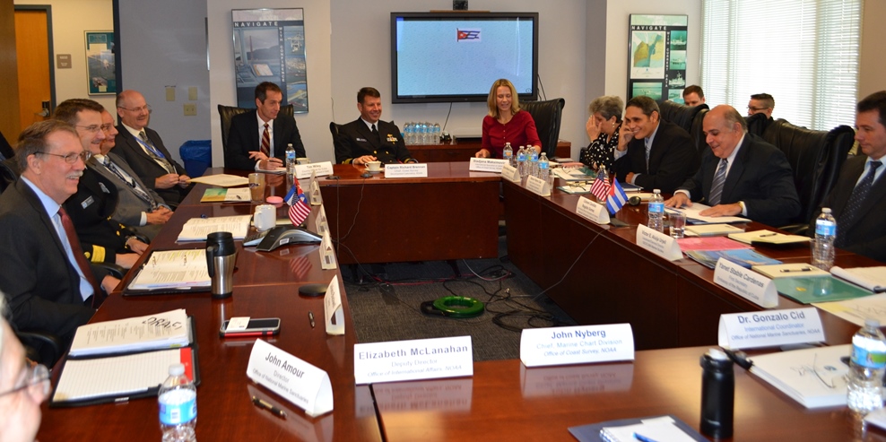
So you want to chart an artificial reef?

There are literally millions of pieces of data on nautical charts. How do cartographers determine which data to put on the charts? Two Coast Survey cartographers, Paul Gionis and Lance Roddy, explained some of the processes, protocols, and NOAA charting requirements to participants at the Florida Artificial Reef Summit earlier this month. (See the archived video of their presentation, starting at 55:40.) Among their many duties, these cartographers are responsible for vetting artificial reef public notices and permits from the U.S. Army Corps of Engineers, and for acquiring source data from the state and county reef coordinators.
By explaining the nautical chart aspects of planning, creating, and maintaining fish havens, they hoped to smooth out the permitting and charting phases.
Continue reading “So you want to chart an artificial reef?”

Geographic names disappear from charts, but not from history — #Data4Coasts

by Meredith Westington, Coast Survey geographer
Good, informed decisions are often based on analyses of historic and present conditions. Researchers, decision-makers, and amateur history buffs find detailed documentation of past conditions in the thousands of Coast Survey charts, dating back to the mid-1800s, in our Historical Map and Chart Collection.
Just like present day nautical charts, historic charts contain a wealth of information about geographic features — including their names, shape, and condition. Geographic names are important locational references for today’s emergency responders, but current and historic names also convey important aspects of local people and culture, which may persist through time.
Continue reading “Geographic names disappear from charts, but not from history — #Data4Coasts”

Great Lakes mariners get new NOAA nautical chart for St. Mary’s River

Vessel operators transiting St. Mary’s River, between Lake Superior and the lower Great Lakes, have a new nautical chart to help lessen the dangers inherent in this narrow and complicated waterway. The first edition of Chart 14887 (St. Marys River – Vicinity of Neebish Island) is available this week as a paper print-on-demand chart, PDF, and raster navigational chart. The electronic navigational chart will be available by March, in time for the beginning of the shipping season. (UPDATE, 2/12/14: NOAA ENC US5MI50 is now available.)
Coast Survey has built the chart from original sources, providing the highest standard of accuracy for hydrographical and topographical features and aids to navigation. The chart provides large-scale (1:15,000) coverage of the up bound and down bound channels of the St. Mary’s River – one of the busiest waterways in the nation. Over 4,100 transits of commercial and government vessels move about 75 million tons of cargo through the 300-day shipping season.
Continue reading “Great Lakes mariners get new NOAA nautical chart for St. Mary’s River”

Coast Survey unveils NOAA ENC Online Viewer

For more than ten years, since NOAA introduced its electronic navigational charts, you have needed to purchase a specialized chart display system to view the NOAA ENC® as a seamless chart database. Starting today, you don’t need a system to view the ENC depictions; you can use Coast Survey’s new web-based viewer called NOAA ENC® Online. (IMMEDIATE CAVEAT: You still need a specialized display system to use the multi-layered functional data that make ENCs so valuable. NOAA ENC downloads are still free to the public.)

Screengrab from NOAA ENC Online

Continue reading “Coast Survey unveils NOAA ENC Online Viewer”

Better nautical chart images coming to electronic charting systems

Things are changing for U.S. nautical charts. We think you’re really going to like this improvement!

Continue reading “Better nautical chart images coming to electronic charting systems”

After ten years of NOAA ENCs, nearly 10 million (free) downloads per month!

It was only ten short years ago that NOAA began issuing electronic navigational charts (NOAA ENC®) as official products. As we look back, the promises of a product that emerged a decade ago continue to beckon, with even more uses and greater usage.
“We still make the traditional paper charts that mariners have depended on, but the world of navigation is changing, and Coast Survey is helping to lead that change,” explains Rear Admiral Gerd Glang, director of NOAA’s Office of Coast Survey. “Increasingly, mariners use – and soon will be required to use – electronic systems and displays to view and manage the safe navigation of their ships.”
Continue reading “After ten years of NOAA ENCs, nearly 10 million (free) downloads per month!”

U.S. Chart No. 1 moves into electronic age

For the 65 years since the U.S. Coast and Geodetic Survey issued the first edition of U.S. Chart No.1 in 1948, mariners have had a standard guide for understanding the symbols, abbreviations and terms used on paper nautical charts. In a major step forward, a new edition of that guide also describes the symbols specified by the International Hydrographic Organization for the display of electronic navigational charts (ENC) on Electronic Chart Display and Information Systems (ECDIS).
SymbolGlobeSeveral maritime nations produce their own versions of Chart 1. The U.S. Chart No. 1 describes the symbols used on paper nautical charts produced by NOAA and the National Geospatial-Intelligence Agency (NGA). The new U.S. Chart No. 1 is the first “Chart 1” produced by any country to show paper and electronic chart symbology side by side.
Continue reading “U.S. Chart No. 1 moves into electronic age”

NOAA’s new nautical chart improves safety for maritime gateway to the Arctic

NOAA Office of Coast Survey has released a new nautical chart for the Arctic, which will help mariners navigate the Bering Strait. Chart 16190 (Bering Strait North) incorporates precise depth measurements acquired recently by NOAA Ship Fairweather hydrographic surveys.
Coast Survey has also released a new edition of Chart 16220 (St Lawrence Island to Bering Strait).
“Our Arctic Nautical Charting Plan identified the need for 14 new charts in the Arctic,” explains Commander Shep Smith, chief of Coast Survey’s Marine Chart Division. “Chart 16190 was high on our list of priorities, since the Bering Strait is the maritime gateway from the Bering Sea in the Pacific Ocean to the Chukchi Sea in the Arctic Ocean.”
Continue reading “NOAA’s new nautical chart improves safety for maritime gateway to the Arctic”

Updated Arctic chart mitigates risk for commercial transportation on the Kuskokwim

By Andrew Kampia, chief of Products Branch A, Marine Chart Division, Office of Coast Survey
When we say that many Arctic charts are lacking information critical to navigation, we’re not overstating the issue. A case in point was the 2005 edition of Chart 16304, depicting the mouth of Kuskokwim River to the City of Bethel, in Alaska. This was a preliminary chart with no hydrography, no depth measurements whatsoever.

Chart 16304 - 2005
Preliminary Chart 16304, issued in 2005

Coast Survey just released updated NOAA Chart 16304, which now includes contemporary shoreline and hydrography. (The NOAA ENC® equivalent — US4AK85M — will be available in a month or two.)
Continue reading “Updated Arctic chart mitigates risk for commercial transportation on the Kuskokwim”