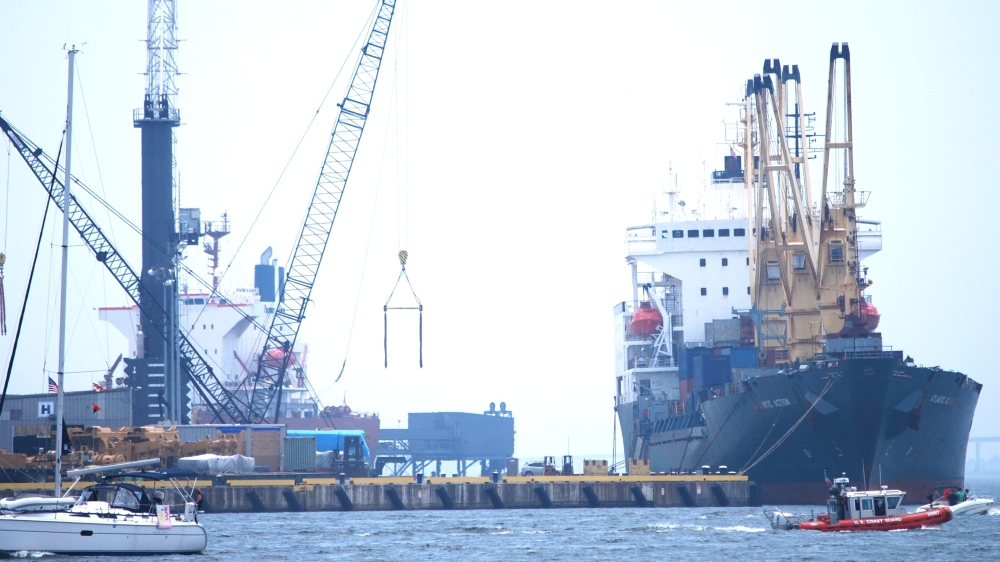
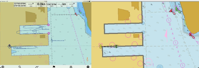
NOAA’s Office of Coast Survey quickly updated NOAA electronic navigational charts (NOAA ENC®) to accurately reflect the 225 foot expansion of a slip in Port Everglades, Florida. Now at a total length of 1,125 feet, the elongated slip allows larger ships to dock with confidence. The Port Everglades Pilots – maritime pilots who maneuver ships through crowded harbors and confined waters – requested the chart update. With ENCs that accurately reflect the slip expansion in their hands, pilots can easily communicate to vessel captains that it is safe to dock their vessels in the slip.
Port Everglades is one of the top three cruise ports in the world, and is among the most active cargo ports in the United States. Every slip is kept in high use, and Coast Survey used a new data process that allowed the most critical and valuable information to be applied quickly and made available to the end user. Continue reading “NOAA quickly updates nautical chart, allowing large ships to dock with confidence in Port Everglades”
NOAA RNC Tile Service displays first ENC-only product
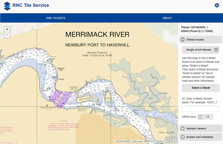
NOAA Office of Coast Survey released its 1:12,000 electronic navigational chart (NOAA ENC®) of the Merrimack River, Massachusetts, in the RNC Tile Service. This is the first time a navigational chart—created solely as ENC product—is included in the tile service. The tile service renders a traditional depiction of the nautical chart for use with GPS-enabled electronic chart systems or other “chart plotter” display systems to provide real-time vessel positioning for recreational mariners. This chart is included in the single chart tile sets and the quilted tile sets both in the online and offline versions. Continue reading “NOAA RNC Tile Service displays first ENC-only product”
NOAA clarifies National Charting Plan vision for production of NOAA paper charts and RNCs
Whether navigating an oil tanker, cruise ship, fishing vessel, sailboat, or any craft, the mariner requires a suite of navigation charts that are consistent and easy to use. The public feedback we received to the National Charting Plan regarding the “sunset of paper” charts (p. 26) highlights two navigation products in particular, NOAA paper nautical charts and raster navigational chart (RNC).
Continue reading “NOAA clarifies National Charting Plan vision for production of NOAA paper charts and RNCs”
Collaborative effort to create new nautical chart returns recreational boaters to Haverhill, Massachusetts
NOAA’s Office of Coast Survey released a new electronic navigation chart (NOAA ENC®) of Haverhill, Massachusetts, and the Merrimack River (US5MA1AM). With this new chart, recreational boaters now can safely navigate the Merrimack River from the entrance at Newburyport all the way to Haverhill, just in time for boating season.
Haverhill is a historic New England town that has recently undergone an urban renewal with new federal, state, and private investment in the downtown and waterfront areas. Until now, this area of the river was not depicted at an appropriate scale on a nautical chart for recreational boaters to navigate safely. The community of Haverhill recognized the importance of recreational boaters to their local economy and led a grassroots effort to have a new chart created. Continue reading “Collaborative effort to create new nautical chart returns recreational boaters to Haverhill, Massachusetts”
NOAA Coast Survey, Coast Guard, and Army Corps of Engineers schedule public “listening sessions”
Over the past few decades, mariners have witnessed the rapid development, reliability, and availability of e-navigation components, such as the global positioning system (GPS) and electronic chart display and information systems (ECDIS). These systems, and other technology, have fundamentally changed mariners’ reliance on traditional navigation services. In addition, the ability to manage data and information provided to the mariner through the automatic identification system (AIS) and cellular service has enhanced the interconnectivity between shore side information providers and shipboard users. These technological advances and data flow will help the mariner receive data, transmit data, and generally improve bridge resource management, situational awareness, and navigational safety.
Continue reading “NOAA Coast Survey, Coast Guard, and Army Corps of Engineers schedule public “listening sessions””
Catch the digital wave in NOAA navigation products #Data4Coasts

This week, NOAA’s National Ocean Service is inviting you to explore #Data4Coasts that NOS provides to the public, to researchers and decision makers, and to the many industries involved in coastal resilience and maritime commerce. Much of Coast Survey’s data for the coasts is easily accessible by downloading or by using a web map. Other products, like our beautiful printed nautical charts, are available for purchase – as they have been since the mid-1800s – from chart agents.
We’ve been making charts for a long time – and we’ve never been more excited about it! A quickly evolving (r)evolution is transforming the way we plan voyages and navigate, and Coast Survey is reconstructing our nautical product line for the millions of boaters and commercial pilots who are catching the new digital wave.
Continue reading “Catch the digital wave in NOAA navigation products #Data4Coasts”
Better nautical chart images coming to electronic charting systems
Things are changing for U.S. nautical charts. We think you’re really going to like this improvement!
- Last week, Coast Survey announced that most of our nautical charts are available for free download as PDFs (Adobe Portable Document Format).
- Before that, we announced that the government will stop printing lithographic nautical charts after April 13, but chart users can still get printed charts from a NOAA-certified Print-on-Demand chart provider.
- Today, we have good news for boaters with electronic charting systems that use NOAA raster navigational charts (NOAA RNC®): your charts are going to be easier to read.
Continue reading “Better nautical chart images coming to electronic charting systems”
After ten years of NOAA ENCs, nearly 10 million (free) downloads per month!
It was only ten short years ago that NOAA began issuing electronic navigational charts (NOAA ENC®) as official products. As we look back, the promises of a product that emerged a decade ago continue to beckon, with even more uses and greater usage.
“We still make the traditional paper charts that mariners have depended on, but the world of navigation is changing, and Coast Survey is helping to lead that change,” explains Rear Admiral Gerd Glang, director of NOAA’s Office of Coast Survey. “Increasingly, mariners use – and soon will be required to use – electronic systems and displays to view and manage the safe navigation of their ships.”
Continue reading “After ten years of NOAA ENCs, nearly 10 million (free) downloads per month!”
U.S. Chart No. 1 moves into electronic age
For the 65 years since the U.S. Coast and Geodetic Survey issued the first edition of U.S. Chart No.1 in 1948, mariners have had a standard guide for understanding the symbols, abbreviations and terms used on paper nautical charts. In a major step forward, a new edition of that guide also describes the symbols specified by the International Hydrographic Organization for the display of electronic navigational charts (ENC) on Electronic Chart Display and Information Systems (ECDIS).
 Several maritime nations produce their own versions of Chart 1. The U.S. Chart No. 1 describes the symbols used on paper nautical charts produced by NOAA and the National Geospatial-Intelligence Agency (NGA). The new U.S. Chart No. 1 is the first “Chart 1” produced by any country to show paper and electronic chart symbology side by side.
Continue reading “U.S. Chart No. 1 moves into electronic age”
What is the future of e-Navigation? CMTS wants to hear from you
The U.S. Committee on the Marine Transportation System, a federal inter-agency partnership that develops national MTS policy, is asking for your ideas on the future of e-navigation.
They’ve set up a unique online site to facilitate the conversation, and they invite anyone with an interest in the U.S. marine transportation system to join the discussion. (Deadline for comments is February 28.) For background, you might want to read the committee’s e-Navigation Strategic Action Plan.
 As defined by the International Maritime Organization (IMO), e-navigation is “the harmonized collection, integration, exchange, presentation, and analysis of maritime information onboard and ashore by electronic means to enhance berth-to-berth navigation and related services for safety and security at sea and protection of the marine environment.”
Continue reading “What is the future of e-Navigation? CMTS wants to hear from you”


