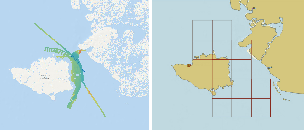
On November 16, 2018, NOAA released ASSIST, a new system for submitting questions and reporting nautical chart errors to NOAA’s Office of Coast Survey. ASSIST has a mobile-friendly design and improved user interface that allows customers to access the system conveniently from any device. This new tool replaces Coast Survey’s Inquiry and Discrepancy Management System (IDMS), a database that collected nearly 20,000 comments, inquiries, and discrepancy reports since 2008. ASSIST is available from: https://www.nauticalcharts.noaa.gov/customer-service/assist/ Continue reading “NOAA makes it easier to submit a comment or report a nautical chart error”
NOAA hosts Navigation Industry Day 2018
NOAA recently hosted its fourth NOAA Navigation Industry Day at the Annapolis Yacht Club adjacent to this year’s Annapolis Boat Show. This annual event welcomed maritime application and navigation system developers interested in learning about the latest freely-available navigation-related data streams, models, and products that NOAA offers. Continue reading “NOAA hosts Navigation Industry Day 2018”
NOAA welcomes local and international attendees at 2018 Nautical Cartography Open House
Last week NOAA Coast Survey welcomed approximately 170 attendees representing 17 countries to the 2018 Nautical Cartography Open House. Industry partners, members of the public, and other government agencies attended, including the Bureau of Ocean Energy Management, Naval Hydrographic and Oceanic Service (SHOM) from France, Canadian Hydrographic Service, Dalian Naval Academy, National Taiwan Ocean University, and the Joint Hydrographic Center/Center for Coastal and Ocean Mapping (JHC/CCOM).
Continue reading “NOAA welcomes local and international attendees at 2018 Nautical Cartography Open House”
From seaports to the deep blue sea, bathymetry matters on many scales
By Rear Adm. Shep Smith, director of the Office of Coast Survey
On Thursday, June 21, we celebrate World Hydrography Day. This year’s theme—Bathymetry – the foundation for sustainable seas, oceans and waterways—is very timely as many hydrographic organizations worldwide are focusing on bathymetry at local and global scales. While we work to perfect real-time data and high-resolution bathymetry for ports, we are still working to build a foundational baseline dataset of the global seafloor. Our work at both scales have implications for the local and global economies.
Continue reading “From seaports to the deep blue sea, bathymetry matters on many scales”
The world of S-100: Updated framework of maritime data standards to be released in 2018
By Julia Powell, deputy chief of the Coast Survey Development Lab
As e-Navigation becomes more popular, mariners are provided with streams of maritime data from multiple sources that allow them to more safely and efficiently navigate the seas. However, as the amount of information and number of sources grows, there is a need to standardize the data so it can be easily integrated and seamlessly displayed on navigation systems. Later this year, the International Hydrographic Organization (IHO) will publish edition 4.0.0 of S-100 – Universal Hydrographic Data Model. S-100 is the IHO’s framework for the standardization of maritime data products such as high resolution bathymetry, surface currents, marine protected areas, and the new standards for electronic navigational charts (ENCs).
Continue reading “The world of S-100: Updated framework of maritime data standards to be released in 2018”
First U.S. federal channel using USACE survey data receives improved quality classification from NOAA
By Rachel Medley
The U.S. federal channel in the Delaware Bay is vital to maritime commerce, leading deep draft vessel traffic to and from the major ports of Wilmington, Delaware, Philadelphia, Pennsylvania, and Camden, New Jersey. To navigate this federally maintained waterway safely and efficiently, mariners rely on the surveyed depths displayed on nautical charts. The U.S. Army Corps of Engineers (USACE) Philadelphia District regularly surveys this area, utilizing sophisticated techniques and equipment to map the depths of the seafloor. NOAA’s Office of Coast Survey, in turn, adds quality classifications to these channel depths and displays them on the nautical chart.
The portion of the federal channel from Newbold Channel Range down to the mouth of the Delaware Bay is the first waterway in the U.S. to have an improved quality classification assigned to USACE survey data—category of zone of confidence (CATZOC) A2. Improving survey quality and upgrading the CATZOC classification allows operators to accommodate smaller margins of error while still ensuring that navigating maritime approaches and constrained environments remain safe. These decreased tolerances allow ships to maximize their loads, ultimately increasing inbound and outbound cargoes.
Continue reading “First U.S. federal channel using USACE survey data receives improved quality classification from NOAA”
NOAA makes forecast data easier to display in marine navigation systems
By Neil Weston, Office of Coast Survey Technical Director
Have you ever been on the water when weather and sea conditions suddenly change? As mariners can attest, decisions need to be made quickly. Many rely on NOAA operational forecast system (OFS) data—a national network of nowcast and forecast models—to make decisions about their situation on the water. NOAA OFS are available to the mariner as data streams through a variety of websites, including nowCOAST™. However, only recently has OFS data been viewable on marine navigation systems, making it even more convenient for those needing to make critical decisions on the water.
Continue reading “NOAA makes forecast data easier to display in marine navigation systems”
NOAA adds grid overlay to chart anchorage areas in Port of New York and New Jersey
NOAA Coast Survey recently released updates for two NOAA electronic navigational charts (NOAA ENC®) in the Port of New York and New Jersey, which added a permanent grid system overlay to anchorages in Bay Ridge, Graves End, and Stapleton. Coast Survey performed the update at the request of the Harbor Operations Steering Committee and collaborated with the Sandy Hook Pilots Association and U.S. Coast Guard (USCG) Sector New York’s Vessel Traffic Services (VTS).
Continue reading “NOAA adds grid overlay to chart anchorage areas in Port of New York and New Jersey”
NOAA navigation response team investigates hazardous shoal off Rockaway Point, NY
Recently, NOAA navigation response team 5 (NRT5), responded to a survey request from U.S. Coast Guard (USCG) Sector New York following several groundings near Rockaway Point in Queens, New York. Waves and currents often influence the size and shape of nearshore sandbars, and the USCG was concerned that a sandbar may have expanded beyond the area depicted on the nautical chart. Lt. j.g. Dylan Kosten, Eli Smith, and Michael Bloom traveled from New London, Connecticut, to Jersey City, New Jersey, to launch their vessel and start the survey of the area.
Continue reading “NOAA navigation response team investigates hazardous shoal off Rockaway Point, NY”
NOAA quickly updates nautical chart, allowing large ships to dock with confidence in Port Everglades
NOAA’s Office of Coast Survey quickly updated NOAA electronic navigational charts (NOAA ENC®) to accurately reflect the 225 foot expansion of a slip in Port Everglades, Florida. Now at a total length of 1,125 feet, the elongated slip allows larger ships to dock with confidence. The Port Everglades Pilots – maritime pilots who maneuver ships through crowded harbors and confined waters – requested the chart update. With ENCs that accurately reflect the slip expansion in their hands, pilots can easily communicate to vessel captains that it is safe to dock their vessels in the slip.
Port Everglades is one of the top three cruise ports in the world, and is among the most active cargo ports in the United States. Every slip is kept in high use, and Coast Survey used a new data process that allowed the most critical and valuable information to be applied quickly and made available to the end user. Continue reading “NOAA quickly updates nautical chart, allowing large ships to dock with confidence in Port Everglades”