By Rear Adm. Shep Smith, director of the Office of Coast Survey
On Thursday, June 21, we celebrate World Hydrography Day. This year’s theme—Bathymetry – the foundation for sustainable seas, oceans and waterways—is very timely as many hydrographic organizations worldwide are focusing on bathymetry at local and global scales. While we work to perfect real-time data and high-resolution bathymetry for ports, we are still working to build a foundational baseline dataset of the global seafloor. Our work at both scales have implications for the local and global economies.
Let me start with the global seafloor. For the untrained eye, particularly those looking at a Google Earth image, it would appear that the monumental task of mapping the seafloor is accomplished. Geologic features appear detailed under a deep sea of blue. Little do most people know, however, that the majority of this surface is interpolated. In other words, we do a good job filling in the blank spaces between the sparse depth measurements we have. This creates a pretty picture, but does not provide valuable and much needed data for resource management, offshore energy planning, mineral extraction, and other fields of research that require high-resolution data to do meaningful work and build on existing scientific knowledge. In fact, the United Nations proclaimed a Decade of Ocean Science for Sustainable Development (2021-2030) and calls for an increase in scientific knowledge of the ocean to support the sustainable management of marine resources and development of the blue economy.

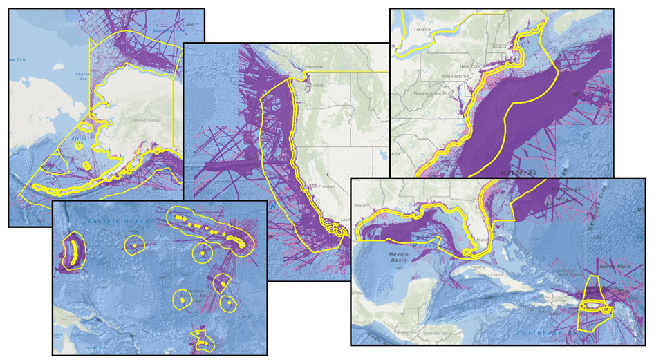
Here in U.S. waters, we are working to help fill these gaps by supporting the Seabed 2030 initiative and maximizing the societal value of the data that is collected. Using multibeam echo sounders that survey large swaths of the ocean floor, we can collect a tremendous volume of bathymetry data along with water column and acoustic backscatter data aiding in habitat mapping. There is also increasing activity in seabed mapping to support offshore wind development and seabed minerals mining. Further, we are working with partners, state and federal agencies, and citizen science and crowdsourced programs to coordinate the collection and sharing of data. These efforts enable us to work toward increasing the breadth of data collection by covering an expanded geographic scope but also the depth of data by collecting data beyond simply bathymetry.

Zooming in from the global scale to individual ports, our focus changes. Our concern is no longer building a baseline dataset for longer-term research needs but getting ships in and out of port in the safest and most efficient way possible. Based on the success of the Long Beach pilot project, NOAA offices involved with precision navigation were awarded additional funding to support foundational program management, and established a dedicated team to support the expansion of precision navigation to more ports throughout the country in the coming years.

Whether working on the building blocks of a global high resolution bathymetric data set or customizing precision navigation port-by-port, the key to success is standardization. The latest edition of the International Hydrographic Organization’s (IHO) S-100 framework—increased standardization of maritime data products—will be published this December. NOAA plans to develop new services in line with these new standards, which will begin a new era in electronic navigation.
It is an interesting time in our field. We are still learning, still discovering, still building. We are working every day toward mapping the ocean and developing precision navigation for our major ports. The global community first recognized World Hydrography Day in 2005 when the United Nations General Assembly adopted Resolution A/60/30. We have made a lot of progress in the past 13 years. In another 13 year’s time, we will have just surpassed the 2030 mark. I anticipate that by that time, we will be able to review with pride both our improved understanding of the ocean and sustainable growth of our blue economy.
We are celebrating World Hydrography Day all week! Check our website to see new hydrography- and bathymetry-related stories added each day.

