NOAA announces launch of crowdsourced bathymetry database

The crowdsourced bathymetry database, displayed in the IHO Data Centre for Digital Bathymetry Data Viewer, has an updated user interface.

By Lt. Cmdr. Adam Reed, Integrated Oceans and Coastal Mapping (IOCM) assistant coordinator

Today NOAA announces the end of a testing phase in the development of a new crowdsourced bathymetry database. Bathymetric observations and measurements from participants in citizen science and crowdsourced programs are now archived and made available to the public through the International Hydrographic Organization (IHO) Data Centre for Digital Bathymetry (DCDB) Data Viewer. The operationalized database allows free access to millions of ocean depth data points, and serves as a powerful source of information to improve navigational products.
Continue reading “NOAA announces launch of crowdsourced bathymetry database”

NOAA makes forecast data easier to display in marine navigation systems

By Neil Weston, Office of Coast Survey Technical Director

Have you ever been on the water when weather and sea conditions suddenly change? As mariners can attest, decisions need to be made quickly. Many rely on NOAA operational forecast system (OFS) data—a national network of nowcast and forecast models—to make decisions about their situation on the water. NOAA OFS are available to the mariner as data streams through a variety of websites, including nowCOAST™. However, only recently has OFS data been viewable on marine navigation systems, making it even more convenient for those needing to make critical decisions on the water.
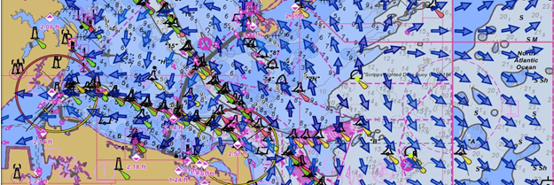
Rose Point’s Coastal Explorer displays NOAA surface current data.
Rose Point’s Coastal Explorer, one example of many navigation software packages available, displays NOAA surface current data.

Continue reading “NOAA makes forecast data easier to display in marine navigation systems”

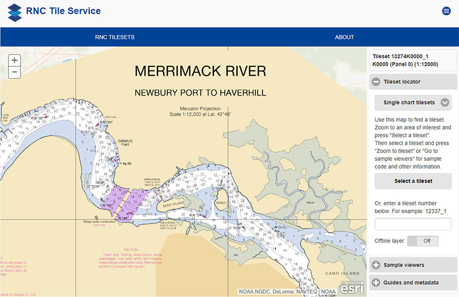
NOAA RNC Tile Service displays first ENC-only product

The Merrimack River, located in Massachusetts, is just south of the New Hampshire border.The single chart tile set is named​ 13274K0000_1.

NOAA Office of Coast Survey released its 1:12,000 electronic navigational chart (NOAA ENC®of the Merrimack River, Massachusetts, in the RNC Tile Service. This is the first time a navigational chart—created solely as ENC product—is included in the tile service. The tile service renders a traditional depiction of the nautical chart for use with GPS-enabled electronic chart systems or other “chart plotter” display systems to provide real-time vessel positioning for recreational mariners. This chart is included in the single chart tile sets and the quilted tile sets both in the online and offline versions. Continue reading “NOAA RNC Tile Service displays first ENC-only product”

NOAA surveys for recreational boat traffic safety in Tampa Bay

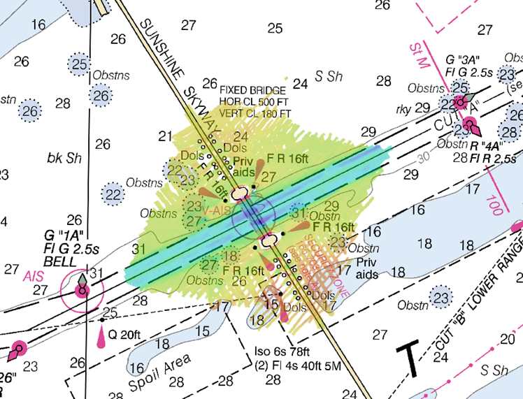
Multibeam echo sounder coverage. Credit: NOAA

NOAA’s navigation response team 2 (NRT2), homeported in Fernandina Beach, Florida, conducted a survey around the Sunshine Skyway Bridge, which spans Tampa Bay. The U.S. Coast Guard (USCG) and additional members of the Tampa Bay Harbor Safety Committee requested the work and expressed interest in establishing alternate routes for recreational boating traffic. Alternative routes will alleviate increasing congestion where the main ship channel passes beneath the bridge. This area is naturally restrictive to navigation and, as a result, there have been multiple accidents and near accidents here in the past. Continue reading “NOAA surveys for recreational boat traffic safety in Tampa Bay”

Is your boat is ready: Remember your nautical chart

Ah, the boat is ready, the safety vests are stowed on board, the sky is blue, and the water beckons… But hold on a sec, sailor! Where is your nautical chart?ChartDefinitionTransparent
A terrific t-shirt is sold in tourist shops at some of our nation’s harbors. It has a “definition” of a nautical chart splayed across the front: “chärt, n: a nautical map that shows you what you just hit.” It’s funny… but unfortunately, too true too often.
Resolve to get your nautical chart this year and consult it before you hit something. Advancements in Coast Survey’s digital processes now allow us to review and update charts weekly, and get them to boaters’ fingertips faster − and with less expense − than was possible years ago.
Continue reading “Is your boat is ready: Remember your nautical chart”

NOAA’s latest mobile app provides free nautical charts for recreational boating

UPDATE: the beta testing period for MyNOAACharts has ended 

Public is invited to try beta version of MyNOAACharts

As recreational boaters gear up for a summer of fun on coastal waters and the Great Lakes, NOAA is testing MyNOAACharts, a new mobile application that allows users to download NOAA nautical charts and editions of the U.S. Coast Pilot. The app, which is only designed for Android tablets for the testing period, was just released.
MyNOAAChart, which can be used on land and on the water, lets users find their positions on a NOAA nautical chart. They can zoom in any specific location with a touch of the finger, or zoom out for the big picture to plan their day of sailing. The Coast Pilot has geo-tagged some of the major references and provides links to appropriate federal regulations.
Continue reading “NOAA’s latest mobile app provides free nautical charts for recreational boating”

Recreational boaters get – and give – free nautical information

Getting free information

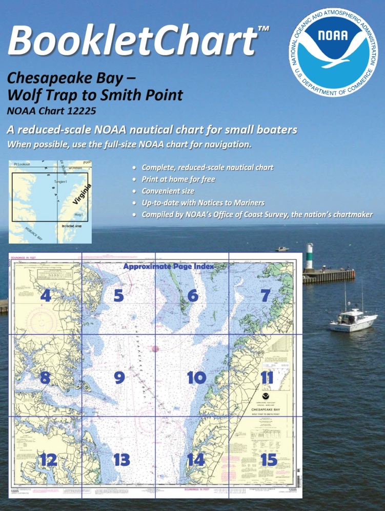
One of NOAA’s handiest navigation products, especially for recreational boaters, has been Coast Survey’s experimental BookletCharts™ — nautical charts that are easy to download and print from home computers. We have now moved the BookletCharts from experimental stage into official production.
BookletChart 12225Nearly a thousand newly updated BookletCharts are available free on the Web. The BookletCharts, which cover the 95,000 miles of U.S. coastline and the Great Lakes, are smaller scale than our traditional paper charts, but they contain most of the information found on a full-scale nautical chart. They are in an 8 1/2 x 11 inch PDF format for home printing.
“It is especially appropriate that we unveil these easy-to-use nautical charts as recreational boaters begin to think about their boating adventures for 2013,” explained Capt. Jon Swallow, chief of NOAA Coast Survey’s Navigation Services Branch. “NOAA’s nautical charts help to protect lives and property, and boaters should take advantage of these free nautical products.”
Continue reading “Recreational boaters get – and give – free nautical information”