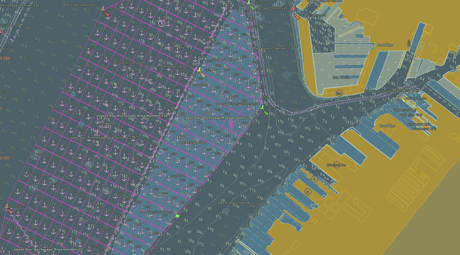
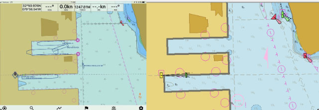
NOAA Office of Coast Survey wraps up a busy 2017 hurricane season

The 2017 Atlantic hurricane season was powerful, with the strongest storms occurring consecutively from late August to early October. The sequential magnitude of four hurricanes in particular—Harvey, Irma, Maria, and Nate—made response efforts challenging for NOAA’s Office of Coast Survey. Coast Survey summarized this season’s response efforts along with the efforts of NOAA Ship Thomas Jefferson (operated by NOAA’s Office of Marine and Aviation Operations) in the following story map. Continue reading “NOAA Office of Coast Survey wraps up a busy 2017 hurricane season”

NOAA travels to Puerto Rico to help ports recover from Hurricane Maria

NOAA loads the MIST kit and crew on board the USCG C-130 aircraft at Naval Air Station Jacksonville.

Hurricane Maria struck the U.S. Virgin Islands (USVI) and Puerto Rico on Wednesday, September 21, as a strong Category 4 hurricane. The storm brought sustained winds of 150 mph and dropped over 18 inches of rain in some areas. Although these islands have seen their fair share of hurricanes and tropical storms, the last storm of this intensity to hit Puerto Rico was the San Felipe Segundo hurricane in 1928. The widespread flooding, winds, and storm surge from Hurricane Maria devastated the islands leaving them without power and their critical ports paralyzed as debris, shoaling, and damaged infrastructure prevents large vessels from entering safely.
Continue reading “NOAA travels to Puerto Rico to help ports recover from Hurricane Maria”

NOAA helps ports recover in Georgia and Florida following Hurricane Irma

View of the first fuel ship entering the Port of Tampa after Hurricane Irma, as it passes NRT 5.

Just as Hurricane Harvey response was wrapping up for some of NOAA Coast Survey’s navigation response teams (NRT), personnel and survey assets were positioned in preparation for the aftermath of Hurricane Irma.   
For the NRTs, this meant traveling hundreds of miles with a survey vessel in tow, facing challenges such as locating fueling stations, finding available lodging, and finding opportunities to rest. For the mobile integrated survey team (MIST), which is available to travel anywhere in the U.S. when hydrographic survey assistance is needed by the U.S. Coast Guard (USCG) or U.S. Army Corps of Engineers (USACE), this meant finding transportation to a disaster area and a  “vessel of opportunity” to survey from once there. Continue reading “NOAA helps ports recover in Georgia and Florida following Hurricane Irma”

NOAA positions personnel and survey assets in preparation for Hurricane Irma

Projected path of Hurricane Irma as seen in nowCOAST™.

As Hurricane Irma approaches Puerto Rico as a Category 5 storm, NOAA is positioning personnel and hydrographic survey assets to help speed the resumption of shipping post storm. In the wake of a hurricane, NOAA’s personnel and survey assets provide essential information when ports need to quickly but safely re-open, limiting significant economic losses caused by prolonged disruptions to the maritime transportation system. Continue reading “NOAA positions personnel and survey assets in preparation for Hurricane Irma”

Coast Survey hurricane prep starts now

Official hurricane season doesn’t start until June 1, but Coast Survey’s navigation managers are heavily involved throughout April and May in training exercises with the U.S. Coast Guard, ports authorities and NOAA’s National Weather Service.
Why is Coast Survey involved? With our expertise in underwater detection, NOAA navigation response teams and survey ships are often the first ones in the water after a hurricane, looking to make sure that no hidden debris or shoaling poses a danger to navigation. The faster we can advise “all clear” to the Captain of the Port, the faster the U.S. Coast Guard can re-open sea lanes for the resumption of shipping or homeland security and defense operations. So our East Coast and Gulf Coast navigation managers – who are NOAA’s “ambassadors” to the maritime public – engage with response partners during hurricane exercises. Their reports of NOAA survey capabilities and assets are an important factor in testing federal response options. Continue reading “Coast Survey hurricane prep starts now”

Assisting tow industry along Chandeleur Sound Alternate Route

The Inner Harbor Navigation Channel in New Orleans facilitates the transportation of tens of millions of tons of cargo each year. Since the channel was recently closed for repairs, a temporary Chandeleur Sound Alternate Route was established to ensure the flow of commerce between the western and eastern reaches of the Gulf Intracoastal Waterway. NOAA experts assisted with the alternate route development in various ways, collaborating with the U.S. Coast Guard, U.S. Army Corps of Engineers, and the maritime industry.
Continue reading “Assisting tow industry along Chandeleur Sound Alternate Route”

Coast Survey uses unmanned technology to find submerged danger to navigation

AUV preparation

Coast Survey has been discovering and marking the locations of underwater dangers since our surveyors took the nation’s first official ocean soundings in 1834. We’ve used or developed all the technological advancements – lead lines, drag lines, single beam echo sounders, towed side scan sonars, and post-1990 multibeam echo sounders – and now we can point to a new major advancement for fast deployment and quick recovery. In February, Coast Survey’s Mobile Integrated Survey Team (MIST) used an autonomous underwater vehicle (AUV) to locate a submerged buoy that was interfering with anchorages in the Chesapeake Bay.
“You and the crew of the HASSLER put us right where we needed to be!” said a confirmation email from the U.S. Coast Guard to NOAA Lt. Ryan Wartick, one of Coast Survey’s navigation managers. “Thanks for the great work!”
Continue reading “Coast Survey uses unmanned technology to find submerged danger to navigation”

Coast Survey assists pilots in efforts to “see” dredging operations on laptop displays

What do pilots see on the navigation laptop displays of their portable pilot units (PPUs) when they guide deep-draft ships to dock? Often, they aren’t seeing all that is actually out there in the navigation channel.
NOAA Coast Survey’s navigation manager Tim Osborn recently observed the problem when he accompanied one of the pilots from the New Orleans Baton Rouge Pilots Association in a ship transit on the Mississippi River.
Continue reading “Coast Survey assists pilots in efforts to “see” dredging operations on laptop displays”

A “soft” resilience strategy is part of successful hurricane response

We hear about the infrastructure investments that often follow major disasters like hurricanes ‒ the “hard” port resilience strategies necessary in the wake of catastrophic human, environmental, and economic loss. But the sturdiest, most flood-proof building is just one part of a larger system of assets in coastal resilience. We don’t hear much about the “soft” resilience strategies ‒ those that build and maintain ties among the people responsible for responding to a hurricane, for instance ‒ that are important to a successful response. Those strategies are part of the social capital between communities and government, and among government agencies.

Coast Survey's Capt. Jon Swallow and Rear Adm. Gerd Glang review charting and survey requirements with Capt. Andrew Melick of of the Biscayne Bay Pilots Association.
Coast Survey’s Capt. Jon Swallow and Rear Adm. Gerd Glang meet with Capt. Andrew Melick of of the Biscayne Bay Pilots Association.

Continue reading “A “soft” resilience strategy is part of successful hurricane response”