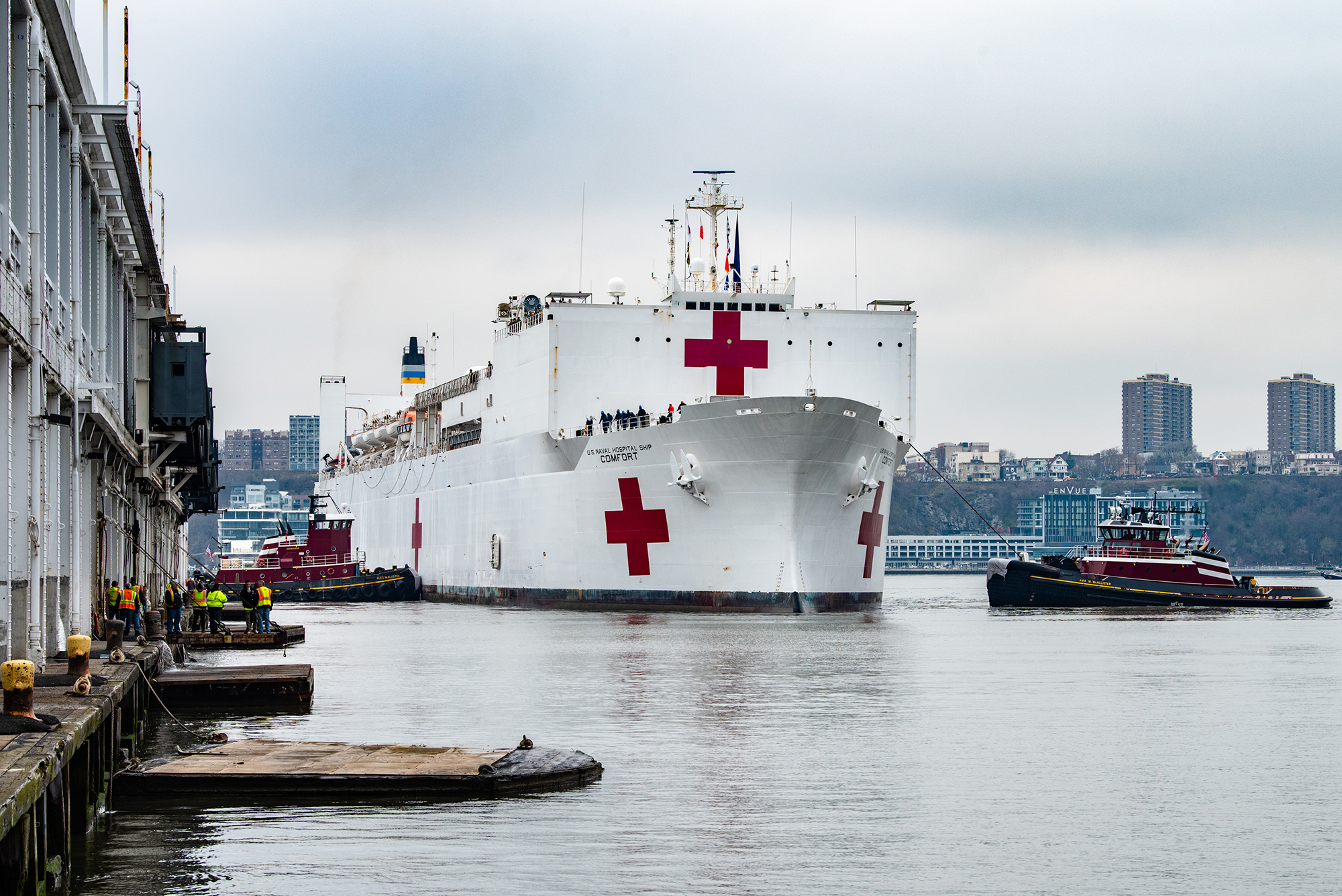
For more than 200 years, nautical cartographers have methodically charted our nation’s coastline, adding new features or hazards and updating meandering shorelines, all in an effort to aid safe navigation. However, occasions do arise that require immediate charting, particularly in response to national emergencies. Notable examples include charting the projected oil spill zone during the Deepwater Horizon oil spill disaster, as well as hazards during hurricane response efforts. Most recently, NOAA’s Office of Coast Survey was called upon to support the arrival of USNS Comfort to New York City.
Continue reading “NOAA supports arrival of USNS Comfort to New York City”NOAA certifies San Francisco Bay shipping channel with top survey rating, increasing confidence for deep draft vessel navigation
There is a risk factor when navigating in and out of our nation’s busiest ports, particularly at the helm of some of the world’s largest deep draft vessels. Mariners rely on tide and water level information, wind and weather data, but perhaps most importantly, they rely on electronic navigational charts and the quality of depth measurements that comprise them. Recently, NOAA’s Office of Coast Survey certified the U.S. Army Corps of Engineers (USACE) hydrographic surveys for the Pinole Shoal Channel in San Francisco Bay — a critical waterway for bulk carriers and tankers to reach the ports of Sacramento, Stockton, Martinez, and Benicia — the highest possible data quality rating, Category Zone of Confidence (CATZOC) A1, for two years. This is the first USACE federally-maintained channel to receive the highest-level certification. NOAA anticipates the increased CATZOC rating will dramatically increase shipping efficiency.
Continue reading “NOAA certifies San Francisco Bay shipping channel with top survey rating, increasing confidence for deep draft vessel navigation”The Great Lakes are getting a digital upgrade
NOAA’s Office of Coast Survey collaborated with U.S. and Canadian mariners, the Lake Carriers’ Association (LCA), and the Canadian Chamber of Marine Commerce (CMC) to update the Recommend Courses in Lake Erie and transfer them from paper charts to NOAA electronic navigational charts (NOAA ENC®). This bi-national effort involved compiling and updating information for Lake Erie’s 75 routes which span both U.S. and Canadian waters. These routes cover 20 NOAA and five Canadian ENCs.
Continue reading “The Great Lakes are getting a digital upgrade”NOAA searches for dangers to navigation following Hurricane Dorian
Storms, particularly hurricanes, can be unpredictable. Therefore, NOAA’s hydrographic survey response teams that aid in the reopening of ports following storms, are designed to be flexible, proactive, and are on call 24/7 should the need arise to identify dangers to navigation.
Continue reading “NOAA searches for dangers to navigation following Hurricane Dorian”NOAA completes hydrographic surveys following Hurricane Barry
By Lt. j.g. Michelle Levano
Seven tropical cyclones in the Atlantic Ocean have been named Barry, with the first storm making landfall in 1983. In 2019, Hurricane Barry reached Category 1 status on July 13, becoming the first hurricane of the 2019 season.
On July 11, Office of Coast Survey’s Gulf Coast Navigation Manager, Tim Osborn, received requests from U.S. Coast Guard, U.S. Army Corps of Engineers, and local ports for resources to confirm navigational depths in Louisiana waters. Once a navigation manager receives requests for hydrographic surveys, Coast Survey formulates logistics to complete these requests. In the case of Hurricane Barry, Coast Survey’s navigation response team (NRT)- Stennis mobilized to respond to Port Fourchon, Louisiana’s southernmost port. Port Fourchon supports significant petroleum industry traffic coming in from the Gulf of Mexico, furnishing about 18% of the U.S. oil supply.
Continue reading “NOAA completes hydrographic surveys following Hurricane Barry”From historic air disasters to hurricane response, NOAA uses cutting edge science to survey the seafloor
By Christine Burns
Hydrographic surveying continually evolves to improve safety, efficiency, and accuracy in data collection. From using side scan sonar equipment during hydrographic survey response efforts following air disasters in the late 1990s, to recent hurricane response efforts to re-open ports to maritime commerce, our science always strives to be cutting edge.
Continue reading “From historic air disasters to hurricane response, NOAA uses cutting edge science to survey the seafloor”Coast Survey spotlight: Meet Lt. Bart Buesseler
Ever wonder what it’s like to be a member of the NOAA Coast Survey team? We use the Coast Survey spotlight blog series as a way to periodically share the experiences of Coast Survey employees as they discuss their work, background, and advice.
Lt. Bart Buesseler, navigation manager
“It is extremely rewarding to interact with our users and see how important our products are to their livelihoods. I’ve always known our work was “important”, but to actually get that feedback on a daily basis from the users motivates me to come to work every day.”
Continue reading “Coast Survey spotlight: Meet Lt. Bart Buesseler”
NOAA surveys the unsurveyed, leading the way in the U.S. Arctic
President Thomas Jefferson, who founded Coast Survey in 1807, commissioned Lewis and Clark’s Corps of Discovery Expedition in 1803, the first American expedition to cross the western portion of the contiguous United States. Today there remains a vast western America territory that is largely unknown and unexplored – the U.S. waters off the coast of Alaska. As a leader in ocean mapping, NOAA Coast Survey launches hydrographic expeditions to discover what lies underneath the waves.
Alaska is one-fifth the size of the contiguous United States, and has more than 33,000 miles of shoreline. In fact, the Alaskan coast comprises 57 percent of the United States’ navigationally significant waters and all of the United States’ Arctic territory. Alaskan and Arctic waters are largely uncharted with modern surveys, and many areas that have soundings were surveyed using early lead line technology from the time of Capt. Cook, before the region was part of the United States. Currently only 4.1 percent of the U.S. maritime Arctic has been charted to modern international navigation standards. Continue reading “NOAA surveys the unsurveyed, leading the way in the U.S. Arctic”
First U.S. federal channel using USACE survey data receives improved quality classification from NOAA
By Rachel Medley
The U.S. federal channel in the Delaware Bay is vital to maritime commerce, leading deep draft vessel traffic to and from the major ports of Wilmington, Delaware, Philadelphia, Pennsylvania, and Camden, New Jersey. To navigate this federally maintained waterway safely and efficiently, mariners rely on the surveyed depths displayed on nautical charts. The U.S. Army Corps of Engineers (USACE) Philadelphia District regularly surveys this area, utilizing sophisticated techniques and equipment to map the depths of the seafloor. NOAA’s Office of Coast Survey, in turn, adds quality classifications to these channel depths and displays them on the nautical chart.
The portion of the federal channel from Newbold Channel Range down to the mouth of the Delaware Bay is the first waterway in the U.S. to have an improved quality classification assigned to USACE survey data—category of zone of confidence (CATZOC) A2. Improving survey quality and upgrading the CATZOC classification allows operators to accommodate smaller margins of error while still ensuring that navigating maritime approaches and constrained environments remain safe. These decreased tolerances allow ships to maximize their loads, ultimately increasing inbound and outbound cargoes.
Continue reading “First U.S. federal channel using USACE survey data receives improved quality classification from NOAA”
Coast Survey prepares to serve nation during 2018 hurricane season
“But, sir, what does the country want in the coast survey? They want a very useful work done, a very important work done, and they want it done in the best manner.” – U.S. Senator John Davis (MA), 1849, explaining the importance of the coast survey to safety and the U.S. economy during the 30th Congress, 2nd Session
As the nation’s nautical chartmaker, NOAA Coast Survey provides critical emergency response information to coastal communities and waterways. Each year, Coast Survey prepares for hurricane season in order to perform the work in—as the late Senator Davis put it—“the best manner.” Last year’s string of powerful hurricanes underscored the importance of coordinated efforts for storm preparation, response, and recovery. With the official start of the 2018 hurricane season just around the corner, Coast Survey’s regional navigation managers spent the large part of April and May meeting with U.S. Coast Guard (USCG), port authorities, NOAA National Weather Service, and communities to prepare emergency response capabilities. Continue reading “Coast Survey prepares to serve nation during 2018 hurricane season”