
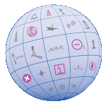
 As a responsible boater, you examine your nautical chart before sailing, determined to avoid problems during a nice trip along the coast. Charts are packed with symbols and abbreviations, so you might refer to the free copy of U.S. Chart No. 1, which lists all of the symbols used on NOAA nautical charts. It is an excellent quick reference for identifying unfamiliar symbols.
However, sometimes mariners need a deeper understanding…
Coast Survey is now providing additional information about complex or particularly confusing chart symbols to augment what is available in U.S. Chart No. 1. The first two tip sheets are available now. Coast Survey will add more chart symbology tip sheets to the U.S. Chart No. 1 webpage as the need arises.
Understanding NOAA chart symbology
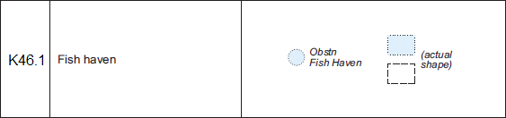
Fish havens: The typical U.S. Chart No. 1 entry, such as this one for fish haven, lists only the name and the symbols. The tip sheet explains what fish havens are, what they look like in context with other charted features, and what restrictions may apply to them.

Anchorages and harbors of refuge: The anchor symbol has been used for decades to represent an anchorage on U.S. nautical charts, but the specific meaning of the symbol has evolved over the years. The tip sheet explains what the symbol means now – and, perhaps more importantly, what it doesn’t mean.
Questions or suggestions? Email USChart1@noaa.gov.
may be a mossback, but I prefer NONMANNED.
I clicked on the link for “tip sheet” and I am getting an error 404 page not found. Is there any other way of getting to the tip sheet page?
thanks
Thank you for your comment. Since this story posted, our website was redesigned. Here is the new page: https://nauticalcharts.noaa.gov/publications/docs/us-chart-1/UnderstandingAnchoragesandHarborsofRefuge-2016Mar.pdf
Hi,
Page not found for http://www.nauticalcharts.noaa.gov/mcd/chartno1.htm
It will be useful to have PDF or a summary web page, with all symbol code updated regularly.
Here is a direct link to U.S. Chart No. 1.
https://nauticalcharts.noaa.gov/publications/us-chart-1.html