NOAA Coast Survey’s new strategy supports charting mandates and broader seafloor mapping

This week, NOAA’s Office of Coast Survey released the Mapping U.S. Marine and Great Lakes Waters: Office of Coast Survey Contributions to a National Ocean Mapping Strategy. This report is part of NOAA’s ongoing commitment to meet core surveying and nautical charting mandates while supporting broader needs to fill gaps in seafloor mapping and environmental sciences.

Continue reading “NOAA Coast Survey’s new strategy supports charting mandates and broader seafloor mapping”

Nautical Chart Manual guides cartographers for 100 years

By John Macek

This July marks the 100th anniversary of the Office of Coast Survey’s Nautical Chart Manual. First published on July 10, 1920, as Special Publication No. 66, under the title “RULES AND PRACTICE RELATING TO CONSTRUCTION OF NAUTICAL CHARTS”, the 34- page pamphlet codified the essential guidelines to be used by cartographers of the U.S. Coast and Geodetic Survey.

Continue reading “Nautical Chart Manual guides cartographers for 100 years”

High-definition charts advance precision marine navigation

Vessel entering the port of Long Beach, California.

By Craig Winn, HD charting portfolio manager

For large vessels entering port where there is next to zero margin for error, pilots and shipmasters are looking for the highest resolution data available to help them navigate these tight spaces safely and efficiently. NOAA’s Office of Coast Survey recently constructed and released 16 high-definition (HD), band 6 (or berthing scale) electronic navigational charts for Los Angeles/Long Beach Harbor, providing mariners with the best charts available to do their job.

Continue reading “High-definition charts advance precision marine navigation”

Explore the refreshed ENC-based NOAA Custom Chart Tool

Updated user interface of the NOAA Custom Chart (NCC) prototype web application displaying the Cape Cod, Massachusetts, region.

Recently, NOAA released an improved user interface for the NOAA Custom Chart (NCC) prototype web application, a tool that allows users to create their own charts from the latest NOAA electronic navigational chart (NOAA ENC®) data. In this refreshed version, NCC settings are simplified and more logically organized, appropriate default values for depth contour labels, depth shades, and compass roses are set, and the NOAA color palette from traditional NOAA paper charts is implemented.

Continue reading “Explore the refreshed ENC-based NOAA Custom Chart Tool”

Coast Survey Spotlight: Meet Martha Herzog

Martha Herzog enjoying the view of Sawyer Glacier in Tracy Arm, Alaska while aboard the "NOAA Ship Rainier."

Ever wonder what it’s like to be a member of the NOAA Coast Survey team? We use the Coast Survey spotlight blog series as a way to periodically share the experiences of Coast Survey employees as they discuss their work, background, and advice.


Martha Herzog, Physical Scientist

“…collecting the most accurate and up-to-date seafloor data to create nautical charting products is essential for ensuring public safety, commerce, and preventing human and environmental catastrophes.” 

Continue reading “Coast Survey Spotlight: Meet Martha Herzog”

NOAA supports arrival of USNS Comfort to New York City

USNS Comfort

For more than 200 years, nautical cartographers have methodically charted our nation’s coastline, adding new features or hazards and updating meandering shorelines, all in an effort to aid safe navigation. However, occasions do arise that require immediate charting, particularly in response to national emergencies. Notable examples include charting the projected oil spill zone during the Deepwater Horizon oil spill disaster, as well as hazards during hurricane response efforts. Most recently, NOAA’s Office of Coast Survey was called upon to support the arrival of USNS Comfort to New York City.

Continue reading “NOAA supports arrival of USNS Comfort to New York City”

Follow the status of electronic navigational chart improvements with NOAA’s new map viewer

New Jersey and surrounding area displayed in the new web map service.

NOAA’s Office of Coast Survey released a new and improved map viewer featuring the status of NOAA electronic navigational charts (NOAA ENC®) as they undergo major improvements. The data is also available as a GIS map service. The public can now view ENC project status from the planning and creation stages all the way to completion, keeping them better informed when these enhanced navigational charts become available.

Continue reading “Follow the status of electronic navigational chart improvements with NOAA’s new map viewer”

Nautical Charts: Marine Navigation Joins the Geospatial Revolution

Electronic navigational chart displayed on an Electronic Chart Display and Information System (ECDIS) on NOAA Ship Thomas Jefferson.

By Rear Adm. Shepard M. Smith

When I traveled around Europe as a young man, my first stop upon leaving the train station in a new city was at the tourist bureau kiosk for a paper city map. On a recent trip to Malaysia, I used my phone to find walking instructions to a street market across town. When I arrived, I described my route to my host, who said that the pedestrian bridge I had used only opened the week before.

Continue reading “Nautical Charts: Marine Navigation Joins the Geospatial Revolution”

Register for NOAA Nav-cast webinar: How to obtain NOAA ENC-based paper nautical charts

Join us for our next NOAA Nav-cast, a quarterly webinar series that highlights the tools and trends of NOAA navigation services.

How to obtain NOAA ENC-based paper nautical charts after NOAA ends production of traditional paper charts

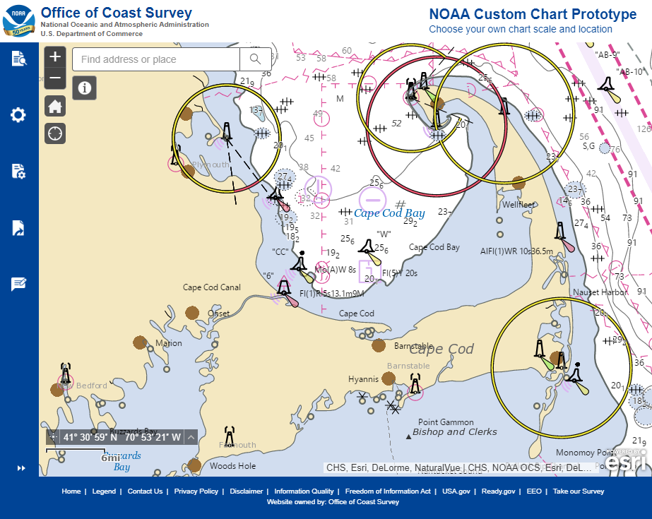
Recently, NOAA announced the start of a five-year process to end traditional paper nautical chart production.  While NOAA is sunsetting its traditional nautical chart products, it is undertaking a major effort to improve the data consistency and provide larger scale coverage within its electronic navigational chart (NOAA ENC®) product suite. Over the next five years, NOAA will work to ease the transition to ENC-based products, such as providing access to paper chart products based on ENC data. The online NOAA Custom Chart prototype application enables users to create their own charts from the latest NOAA ENC data. Users may define the scale and paper size of custom-made nautical charts centered on a position of their choosing. Users may then download, view, and print the output. The application is an easy way to create a paper or digital backup for electronic chart systems.

This webcast will provide an overview of the sunsetting process and a live demonstration of the NOAA Custom Chart prototype, including a discussion of the improvements that are planned for the prototype.

Date and time: Thursday, January 9, 2020, at 2 p.m. (EST)
How to register:  https://attendee.gotowebinar.com/register/7410207397804043779

Saildrone launched with seafloor mapping capabilities in the Gulf of Mexico shows promise for remote Arctic mapping

Rear Adm. Shep Smith, Richard Jenkins, and Brian Connon in front of a Saildrone.

NOAA’s Office of Coast Survey, the University of Southern Mississippi (USM), and Saildrone accomplished a key milestone in the research and testing of unmanned technology that can lead to enhanced seafloor mapping capabilities with the launch of the first Saildrone — a wind-driven and solar-powered unmanned surface vehicle (USV) — equipped with multibeam echo sounder technology in the Gulf of Mexico. NOAA anticipates the success of this mission and technical achievement will lead to mapping projects in the Arctic.

Continue reading “Saildrone launched with seafloor mapping capabilities in the Gulf of Mexico shows promise for remote Arctic mapping”