Coast Survey’s mobile integrated survey team goes to Antarctica

An image of the United States Coast Guard cutter Polar Star docked at McMurdo Station ice pier on a relatively ice free day for Winter Quarters Bay.
By, Annie Raymond

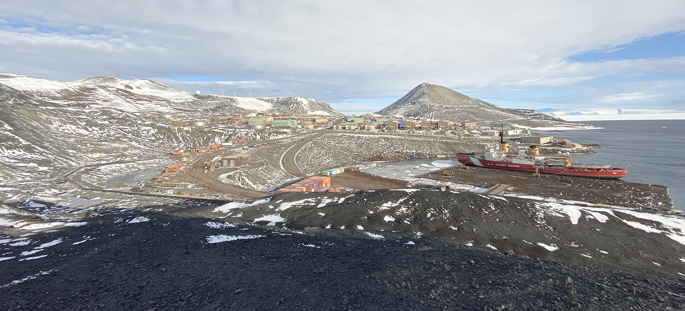
In 1959, following the International Geophysical Year of 1957-58, scientists from twelve nations conducting active research in Antarctica came together and signed the Antarctic Treaty. In the years following, 42 additional countries acceded to the treaty. The treaty preserves the entire continent and surrounding waters solely for purposes of peaceful scientific collaboration and bans resource extraction and military activity. McMurdo Station on Ross Island, operated by the United States through the United States Antarctic Program, a branch of the National Science Foundation (NSF), has emerged as the largest year-round station and primary logistics hub for the region. The first U.S. Operation Deep Freeze happened prior to and in support of the International Geophysical Year of 1957-58. Since then, Operation Deep Freeze has continued annually and has become the name for supply sealift missions to McMurdo, delivering fuel, food, and supplies to scientists in Antarctica.

Continue reading “Coast Survey’s mobile integrated survey team goes to Antarctica”

Coast Survey launches NOAA Chart Display Service

This is a graphic showing an electronic navigational chart depicting the entrance to the Columbia River and Astoria, Oregon. Graphical information on the chart is rendered by the new NOAA Chart Display Service and shows traditional paper chart symbols.

The new NOAA Chart Display Service (NCDS) renders NOAA electronic navigational chart (NOAA ENC®) data with “traditional paper chart” symbology in online and offline applications for which a basemap of nautical chart data is desired, including GIS, web-based, and mobile mapping applications. The new service uses symbols, labels, and color schemes familiar to those who have used NOAA paper nautical charts or the NOAA Custom Chart application. NCDS is available as Esri REST Map Service, OGC Web Map Service (WMS), and MBTiles formats.

Continue reading “Coast Survey launches NOAA Chart Display Service”

Deep fiords and hydrographic history in Glacier Bay National Park

NOAA Ship Rainier at anchor in Bartlett Cove, Glacier Bay National Park.
By Ensign Alice Beittel and Ensign Karl Wagner

Throughout the spring and summer of 2021, NOAA Ship Rainier surveyed numerous bays and inlets of Alaska’s Glacier Bay National Park and Preserve. As one of the largest national wilderness systems and a United Nations designated World Heritage Site, Glacier Bay National Park includes over 2.7 million acres of marine, terrestrial, and freshwater ecosystems. This dynamic landscape is a living example of a never-ending cycle of geological and ecological change and adaptation. With up to 20-foot tide ranges, seasonal migrations of humpback whales and salmon, and glaciers in flux, the resilient ecosystem attracts millions of visitors each year. This year, Rainier surveyed the Beardslee Islands, Geikie Inlet, Berg Bay, Muir Inlet, Bartlett Cove, Pleasant Island, Taylor Bay, and Dundas Bay. Each survey area revealing several changes in seafloor bathymetry and bottom type. High-resolution seafloor bathymetry will be used to update nautical charts for safe navigation and serve as baseline data to support further research of this culturally and ecologically significant marine environment.

Continue reading “Deep fiords and hydrographic history in Glacier Bay National Park”

Learning the ropes aboard a NOAA hydrographic survey vessel

By Natalie Cook

University of New Hampshire’s Center for Coastal and Ocean Mapping and NOAA are giving undergraduate students the opportunity to participate in seafloor mapping and associated exercises aboard a survey vessel this summer. Natalie Cook, a junior in the Ocean Engineering program, is spending eight weeks aboard NOAA Ship Thomas Jefferson, a 208-foot hydrographic survey vessel, experiencing all aspects of hydrography. Natalie is standing survey watch, processing data, working on survey launches, and serving as an active member of the hydrographic survey team.

Continue reading “Learning the ropes aboard a NOAA hydrographic survey vessel”

Surveying the approaches to the Chesapeake Bay

Thomas Jefferson at anchor in Lynnhaven anchorage
By Ensign Gabriella McGann

After a busy winter in port, NOAA Ship Thomas Jefferson started the 2021 field season in familiar waters, returning to survey the approaches of the Chesapeake Bay. Towards the end of the 2020 field season, the crew of the Thomas Jefferson spent their first 45-day “COVID-19 bubble” on this project.  A bubble is formed when crew quarantine and test for COVID-19 prior to crewing the ship, staying isolated onboard until the end of the 45-day period. This protocol is part of the Office of Marine and Aviation Operations (OMAO) COVID-19 mitigation strategy. In April and May of 2021 Thomas Jefferson spent an additional 28 days surveying an area approximately 40 nautical miles east of Virginia Beach, Virginia.

Continue reading “Surveying the approaches to the Chesapeake Bay”

Coast Survey to shut down the Raster Navigational Chart Tile Service and other related services

NOAA will shut down its Raster Navigational Chart (RNC) Tile Service and the online RNC Viewer on October 1, 2021. The NOAA Seamless Raster Navigational Chart Services will be shut down on January 1, 2022. This is part of a larger NOAA program to end production and maintenance of all NOAA traditional paper and raster nautical charts that was announced in the Federal Register in November 2019.

Continue reading “Coast Survey to shut down the Raster Navigational Chart Tile Service and other related services”

Surveying in the Strait of Juan de Fuca during a global pandemic

By Ensign Jessie Spruill and Hydrographic Senior Survey Technician Simon Swart, NOAA Ship Fairweather

Last Thanksgiving, the crew of NOAA Ship Fairweather were busy surveying in one of the country’s busiest waterways. A global maritime entryway to the Pacific Northwest, the Strait of Juan de Fuca sees over 8,000 transits of deep-draft container ships, cargo and chemical carriers, oil tankers, and barges coming to and from Puget Sound and Canada. In addition to industrial shipping, the Strait of Juan de Fuca also supports over 200,000 transits of recreational vessels and Washington State Ferries. Located north of the Olympic Peninsula, the Strait forms the northwestern most border between the contiguous U.S. and Canada. On the American side, the region is home to eight million people including 50 First Nation communities with centuries old cultural ties to traditional fishing.

Continue reading “Surveying in the Strait of Juan de Fuca during a global pandemic”

Coast Survey Spotlight: Meet James Moy

James Moy with chart in background

Ever wonder what it’s like to be a member of the NOAA Coast Survey team? We use the Coast Survey spotlight blog series as a way to periodically share the experiences of Coast Survey employees as they discuss their work, background, and advice.


James Moy, Cartographer

“As a cartographer, I consider it a success if the updates to a chart are accurate and justified, reviewed by another with little or no revisions, and is deemed useful and safe for the public.

Continue reading “Coast Survey Spotlight: Meet James Moy”

Nautical charts reflect alternate route along Gulf Intracoastal Waterway

Portion of Chandeleur Sound Gulf Intracoastal Waterway alternate route.

In anticipation of the temporary closure of the Gulf Intracoastal Waterway (GIWW)’s Inner Harbor Canal Lock, the Office of Coast Survey released three updated NOAA electronic navigational charts (NOAA ENC®) reflecting the Chandeleur Sound Alternate Route and the addition of 97 Aids to Navigation (ATON). The updated charts include US5LA24M, US4LA34M, and US4MS12M and can be viewed in NOAA’s ENC Viewer or downloaded from NOAA’s Chart Locator.

Continue reading “Nautical charts reflect alternate route along Gulf Intracoastal Waterway”