
By Capt. Albert “Skip” Theberge (NOAA, ret.)
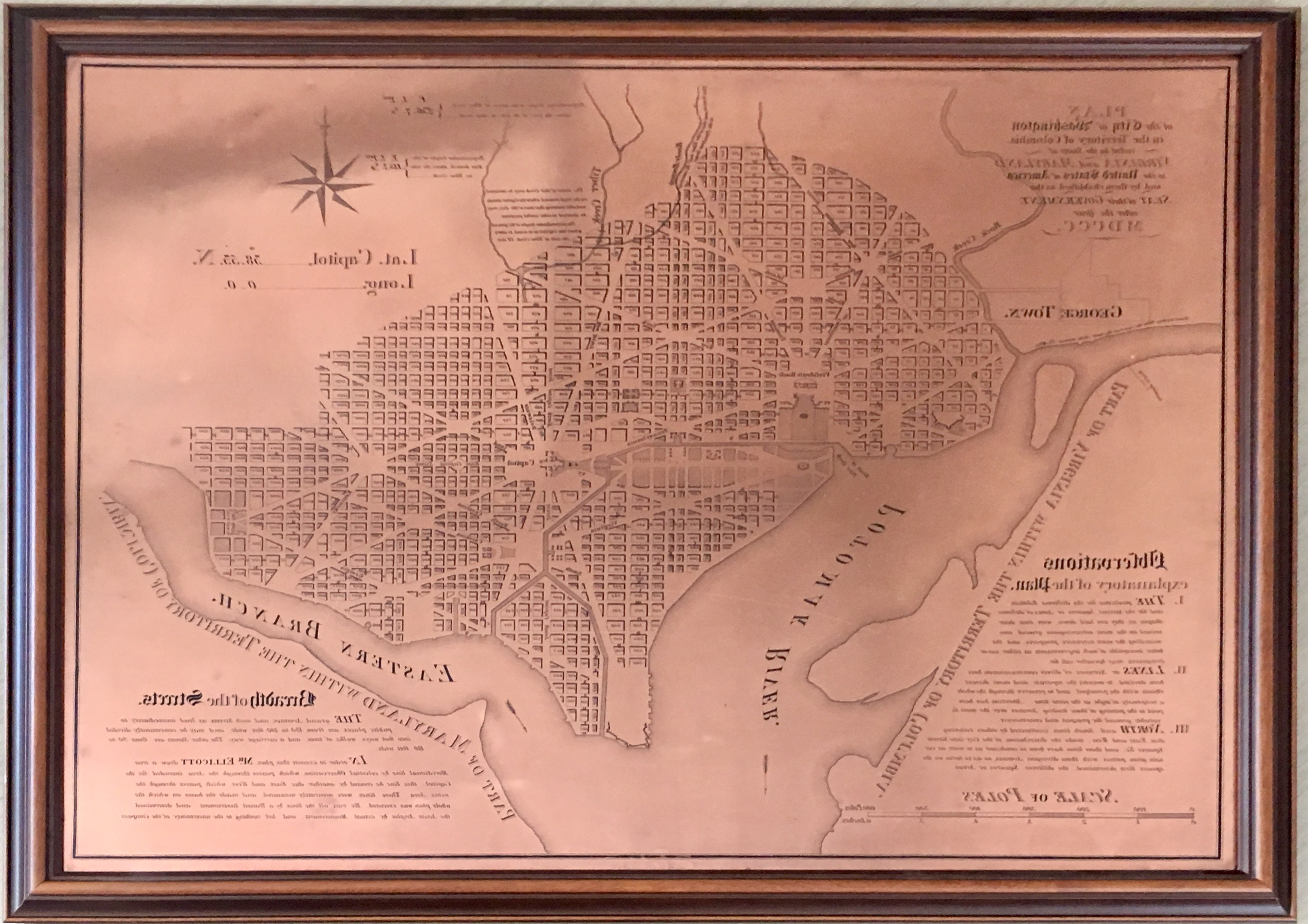
Research conducted by the NOAA Central Library uncovered a little known fact that NOAA Coast Survey’s skill in reproducing maps helped ensure that early maps of Washington, DC, and an interesting piece of history, weren’t lost. Coast Survey reproduced three historically significant maps from a copper plate engraving of Washington, DC, as surveyed by Pierre L’Enfant and Andrew Ellicott.

The three maps were produced as a result of the Potomac Flats case, where a private citizen laid claim to mudflats and shoals that were building outward from the present vicinity of the Tidal Basin. Today, these iconic areas are the site of the Lincoln and Jefferson memorials, as well as the Annual Cherry Blossom Festival.
In 1867, John L. Kidwell, a Georgetown druggist, laid claim to the alluvial land slowly rising from the Potomac. His claim was made possible by an 1839 resolution passed in Congress that allowed vacant lands in the county of Washington and outside the limits of the city of Washington to be claimed. Kidwell’s application was initially rejected by the General Land Office but was approved two years later on December 6, 1869. He paid $23.80, or fifty cents per acre.
On August 2, 1882, Congress made an appropriation for improving the Potomac River, including raising the flats, and made it a duty of the Attorney General to examine all claims of title to clarify the legal situation of the flats. Numerous old maps were consulted as a result of the ensuing lawsuit, including four versions of the L’Enfant plan of the city of Washington, DC. These four maps were: 1) the original L’Enfant plan which had never been reproduced; 2) the Philadelphia map which had been reproduced at the request of Andrew Ellicott by the engraving firm of Thackara and Vallance; 3) the Boston map which had been engraved by Samuel Hill in 1792 and also produced at the request of Andrew Ellicott; and 4) the map printed in the Universal Asylum and Columbian Magazine in 1792.
Coast Survey reproduced the first three of these maps as a result of the lawsuit. The original L’Enfant map was obtained from the Office of Public Buildings and Grounds in very dilapidated condition. It could not be photographed for reproduction and had to be painstakingly reproduced by skilled Coast Survey craftsmen before an engraving could be made from the re-drafted original.

The Philadelphia map is similar to the Boston map engraving. However, it differs from the Boston map as it has No. 3035 45 CENTS, includes soundings in the Potomac River, and shows the street plan of Georgetown, among other small differences. The Philadelphia map is also historically significant because it may be the first printed United States map to show soundings. The Boston map was the Boston copy of the Ellicott map of Washington DC. It was engraved into a copperplate and deposited in the Coast and Geodetic Survey in 1888. This engraving presently resides in the NOAA Central Library and is a NOAA Heritage Asset.
As stated on Coast Survey’s reproduction of the original L’Enfant map, the reproduction was “long demanded by consideration of its historical value, is now rendered absolutely necessary by the requirements of the litigation pending to establish the title of the Government to the Potomac Flats.”
The District of Columbia Supreme Court heard the case in 1895 and ruled against the claimants. They appealed to the Supreme Court of the United States, which also dismissed the Kidwell patent in 1899, stating that the land was within the limits of the city of Washington and therefore the General Land Office did not have the authority under the 1839 resolution to grant the land to citizens. Today, the Potomac Flats land remains property of the federal government and serves as public park land.
Without the expertise of Coast and Geodetic Survey draftsmen, engravers, and printers, the original L’Enfant plan of Washington, DC, and the various versions of Andrew Ellicott and others never would have been seen by the American public or available to the historians and geographers of today.
Hello, my 3rd great Grandfather was John Kidwell owner of Kidwell Flats. I am trying to find copies of any history pertaining to him. I printed out an article which showed a map made by Wm. P. Craighill In 1871. And a Survey list made by B.D. Carpenter in 1867. It’s at the Levy Court (Washington County) 1868, Book 2 page 20. I was wondering if you might have anything that you would share with me. I’m trying to get as much history for my grandchildren as possible. Thank you so much. God bless you for preserving our history.
Hello,
All Coast Survey charts are archived in the Historical Map and Chart Collection. These include charts going back to the 1800’s and also more recently cancelled charts. You can search for charts via keywords or chart numbers and filter by various parameters.