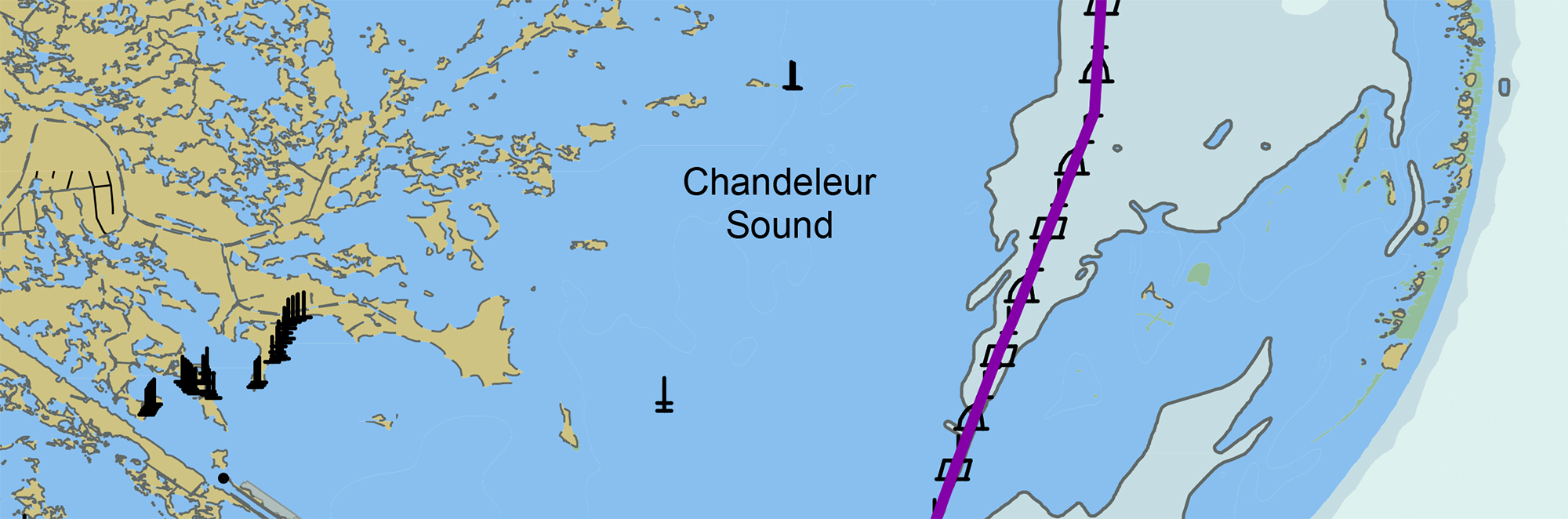
Nautical Chart Manual guides cartographers for 100 years

By John Macek

This July marks the 100th anniversary of the Office of Coast Survey’s Nautical Chart Manual. First published on July 10, 1920, as Special Publication No. 66, under the title “RULES AND PRACTICE RELATING TO CONSTRUCTION OF NAUTICAL CHARTS”, the 34- page pamphlet codified the essential guidelines to be used by cartographers of the U.S. Coast and Geodetic Survey.

Continue reading “Nautical Chart Manual guides cartographers for 100 years”

United States Coast Pilot® covering the Pacific now in two volumes

Coast Pilot 10 cover

What is currently known as United States Coast Pilot® 7 was first published in 1903. The official published name was United States Coast Pilot—Pacific Coast California, Oregon and Washington. Content and information was inclusive of those three states. After Hawaii became a state in 1959, information on the Hawaiian Islands—including the long string of islands and atolls out to Midway Island—was incorporated into the newly titled United States Coast Pilot 7—Pacific Coast California, Oregon, Washington and Hawaii. In 1988, information originally maintained by the National Geospatial-Intelligence Agency under Publication 126 on the remote Pacific Islands (American Samoa, Guam and the Marianas) was added as a new chapter.

Continue reading “United States Coast Pilot® covering the Pacific now in two volumes”

High-definition charts advance precision marine navigation

Vessel entering the port of Long Beach, California.

By Craig Winn, HD charting portfolio manager

For large vessels entering port where there is next to zero margin for error, pilots and shipmasters are looking for the highest resolution data available to help them navigate these tight spaces safely and efficiently. NOAA’s Office of Coast Survey recently constructed and released 16 high-definition (HD), band 6 (or berthing scale) electronic navigational charts for Los Angeles/Long Beach Harbor, providing mariners with the best charts available to do their job.

Continue reading “High-definition charts advance precision marine navigation”

Precision marine navigation surface current dissemination trials

By: Erin Nagel, University Corporation for Atmospheric Research (UCAR) Visiting Scientist

NOAA is preparing to release a prototype of the new Precision Navigation Data Dissemination System in July, and the S-111 surface current forecast guidance will be the first prototype service available in this new system. 

Continue reading “Precision marine navigation surface current dissemination trials”

A message to hydrographers: Your time is now

A global view of mapped and unmapped portions of the world ocean.

By Rear Adm. Shep Smith, Director of NOAA’s Office of Coast Survey

There has never been a better time to be a hydrographer. Our skills, data, and technology are in high demand globally, driven by an increased emphasis both on supporting the blue economy and of protecting the ocean upon which all life on earth depends. The UN declared this decade the “Decade of Ocean Science for Sustainable Development,” and that vision specifically calls out the need to map the world’s oceans. The Nippon Foundation has breathed new energy into the century-long project to create a General Bathymetric Chart of the Oceans (GEBCO) with a supporting campaign called Seabed 2030. Hydrography is now invaluable for habitat mapping, for mineral and energy exploration, for offshore wind development, and for ocean modeling supporting everything from predicting local harmful algal blooms to understanding the earth system itself at a global scale.

Continue reading “A message to hydrographers: Your time is now”

NOAA seeks industry feedback as it begins testing the Precision Navigation Data Dissemination prototype

By Julia Powell, Precision Navigation Program Manager, Chief of the Navigation Services Division

NOAA’s Precision Navigation program is building a prototype data gateway for users to discover, visualize, and disseminate NOAA marine navigation products and services. The backbone of this dissemination system is to provide for machine-to-machine dissemination that allows the mariners’ existing navigation software to automatically discover if NOAA has made new data available and ingest it directly into the system. NOAA’s integrated marine navigation services through this site will help ship operators optimize their routes, save fuel, reduce lightering and reduce port wait times based on environmental conditions.

Continue reading “NOAA seeks industry feedback as it begins testing the Precision Navigation Data Dissemination prototype”

Explore the refreshed ENC-based NOAA Custom Chart Tool

Updated user interface of the NOAA Custom Chart (NCC) prototype web application displaying the Cape Cod, Massachusetts, region.

Recently, NOAA released an improved user interface for the NOAA Custom Chart (NCC) prototype web application, a tool that allows users to create their own charts from the latest NOAA electronic navigational chart (NOAA ENC®) data. In this refreshed version, NCC settings are simplified and more logically organized, appropriate default values for depth contour labels, depth shades, and compass roses are set, and the NOAA color palette from traditional NOAA paper charts is implemented.

Continue reading “Explore the refreshed ENC-based NOAA Custom Chart Tool”

NOAA supports arrival of USNS Comfort to New York City

USNS Comfort

For more than 200 years, nautical cartographers have methodically charted our nation’s coastline, adding new features or hazards and updating meandering shorelines, all in an effort to aid safe navigation. However, occasions do arise that require immediate charting, particularly in response to national emergencies. Notable examples include charting the projected oil spill zone during the Deepwater Horizon oil spill disaster, as well as hazards during hurricane response efforts. Most recently, NOAA’s Office of Coast Survey was called upon to support the arrival of USNS Comfort to New York City.

Continue reading “NOAA supports arrival of USNS Comfort to New York City”

NOAA certifies San Francisco Bay shipping channel with top survey rating, increasing confidence for deep draft vessel navigation

Tanker heading west and approaching the Richmond–San Rafael Bridge and Pinole Shoal Channel.

There is a risk factor when navigating in and out of our nation’s busiest ports, particularly at the helm of some of the world’s largest deep draft vessels. Mariners rely on tide and water level information, wind and weather data, but perhaps most importantly, they rely on electronic navigational charts and the quality of depth measurements that comprise them. Recently, NOAA’s Office of Coast Survey certified the U.S. Army Corps of Engineers (USACE) hydrographic surveys for the Pinole Shoal Channel in San Francisco Bay —  a critical waterway for bulk carriers and tankers to reach the ports of Sacramento, Stockton, Martinez, and Benicia — the highest possible data quality rating, Category Zone of Confidence (CATZOC) A1, for two years. This is the first USACE federally-maintained channel to receive the highest-level certification. NOAA anticipates the increased CATZOC rating will dramatically increase shipping efficiency.

Continue reading “NOAA certifies San Francisco Bay shipping channel with top survey rating, increasing confidence for deep draft vessel navigation”