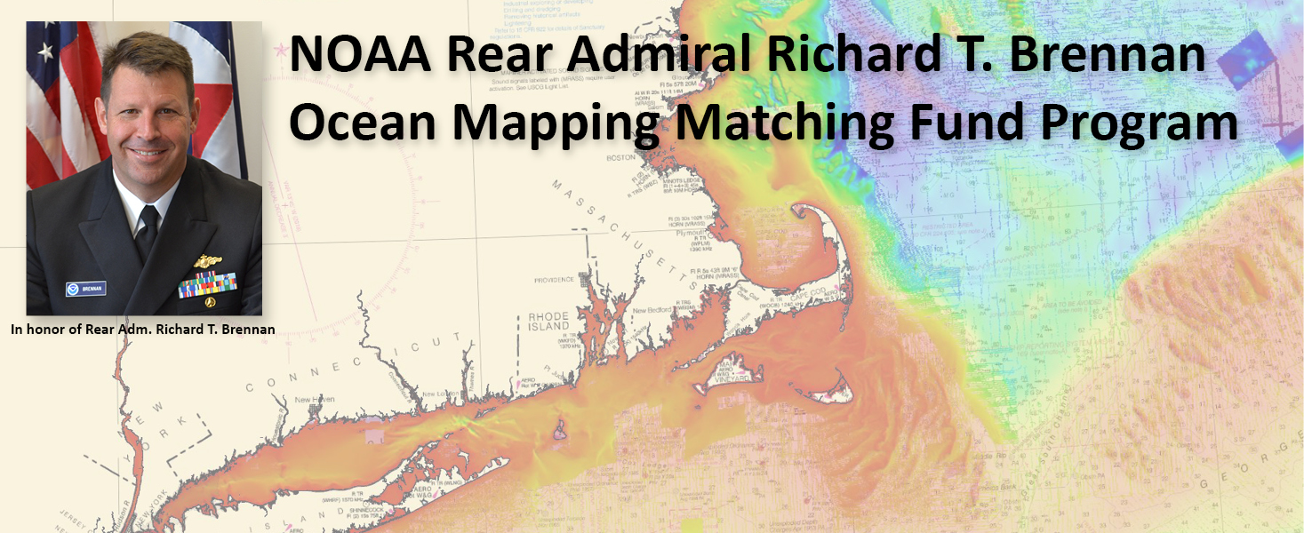
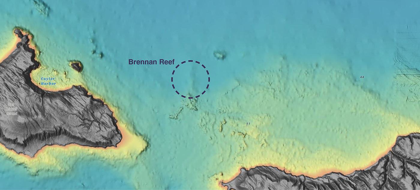
Naming Brennan Reef, a previously uncharted pinnacle in Channel Islands National Marine Sanctuary

Brennan Reef, shown via shaded relief on the National Centers for Environmental Information bathymetric data viewer.

NOAA Corps Rear Adm. Richard T. “Rick” Brennan, recent director of NOAA’s Office of Coast Survey, was deeply dedicated to NOAA’s mission and was an integral part of building connections across NOAA programs to benefit coastal communities around the United States. One example of Rick’s leadership was the Southern California Seafloor Mapping Initiative, a partnership between Coast Survey, Office of National Marine Sanctuaries (ONMS), National Centers for Coastal Ocean Science (NCCOS) and National Marine Fisheries Service (NMFS). Among many important accomplishments of this coordinated mapping effort was the survey of a previously uncharted reef in Channel Islands National Marine Sanctuary. Through legislative action led by U.S. Congressman Salud Carbajal of California’s 24th District, this reef has been officially designated as “Brennan Reef.”

Continue reading “Naming Brennan Reef, a previously uncharted pinnacle in Channel Islands National Marine Sanctuary”

NOAA releases 2023 hydrographic survey season plans

An image showing all NOAA hydrographic survey vessels.

NOAA hydrographic survey ships, navigation response teams, and contractors are preparing for the 2023 hydrographic survey season. The ships and survey vessels collect bathymetric data (i.e. map the seafloor) to support nautical charting, modeling, and research, but also collect other environmental data to support a variety of ecosystem sciences. NOAA considers hydrographic survey requests from stakeholders such as marine pilots, local port authorities, the Coast Guard, and the boating community, and also considers other hydrographic and NOAA science priorities in determining where to survey and when. Visit our “living” ArcGIS StoryMap to find out more about our mapping projects and if a hydrographic vessel will be in your area this year!

Continue reading “NOAA releases 2023 hydrographic survey season plans”

3D Nation Study report, website, and StoryMap now available

The 3D Nation Elevation Requirements and Benefits Study focuses on 3D elevation data on land and under water.

A new StoryMap on the 3D Nation Elevation Requirements and Benefits Study, which was published in September 2022, is now available. Sponsored by the National Oceanic and Atmospheric Administration (NOAA) and the U.S. Geological Survey (USGS), and conducted by Dewberry, the 3D Nation Study documents nationwide requirements and benefits of 3D elevation data both on land and under water. The study also estimates the costs associated with meeting these requirements and evaluates multiple scenarios for enhancing national elevation mapping programs.

Continue reading “3D Nation Study report, website, and StoryMap now available”

Supporting the mighty Columbia River through strong partnerships

An image of the Hood River Bridge crossing the Columbia River.

The Columbia River and its tributaries comprise one of the largest river systems in North America, flowing from British Columbia, Canada and through the United States to its final destination, the Pacific Ocean. The river is used extensively for transporting various cargoes into and out of the United States including forest products, grain, containerized cargo and bulk products like salt and cement. Upstream of Portland, barge and recreational traffic navigate the river to Kennewick, Washington or Lewiston, Idaho on the Snake River. For the people that use this river for its resources, this traffic almost assuredly has some type of ecological impact.

Continue reading “Supporting the mighty Columbia River through strong partnerships”

NOAA Ship Thomas Jefferson completes productive field season in the Great Lakes

A graphic showing the route NOAA Ship Thomas Jefferson took returning back to Norfolk, Virginia after the 2022 field season.

Although NOAA has a significant presence in the Great Lakes, this is the first time a white-hulled NOAA hydrographic ship has deployed there since the early 1990s. As a result of survey work in the Great Lakes, NOAA Ship Thomas Jefferson surveyed 450 square nautical miles of lake bottom in Lake Erie – an economically important and ecologically sensitive region. The ship also surveyed 274 square nautical miles in Lake Ontario in October. In both lakes, there were 42 confirmed and new shipwrecks identified along with 22 additional features!

Continue reading “NOAA Ship Thomas Jefferson completes productive field season in the Great Lakes”

NOAA contributes to Empowering Women in Hydrography through at-sea experience, part 3

An image of Firosa Tomohamat, from Suriname’s Maritime Authority, sitting on a bench on deck 2 of NOAA Ship Thomas Jefferson.

The Empowering Women in Hydrography project is a global effort led by the International Hydrographic Organization and Canada that seeks to initiate, organize and track a series of activities and initiatives which will enable more women to participate equitably in the field of hydrography and to assume leadership roles within the hydrographic community. NOAA is contributing to the project via an ‘at-sea experience’ on NOAA hydrographic ships for three women each year over the four year lifespan of the project. After a global call for nominations, three women were selected to join NOAA ships for the 2022 survey season. Firosa Tomohamat from Suriname’s Maritime Authority, joined NOAA Ship Thomas Jefferson from August 8 to 26, 2022 while surveying the Great Lakes.

Continue reading “NOAA contributes to Empowering Women in Hydrography through at-sea experience, part 3”

NOAA contributes to Empowering Women in Hydrography through at-sea experience, part 2

NOAA ship Thomas Jefferson from survey launch 2904 at sunrise.

The Empowering Women in Hydrography project is a global effort led by the International Hydrographic Organization and Canada that seeks to initiate, organize and track a series of activities and initiatives which will enable more women to participate equitably in the field of hydrography and to assume leadership roles within the hydrographic community. NOAA is contributing to the project via an ‘at-sea experience’ on NOAA hydrographic ships for three women each year over the four year lifespan of the project. After a global call for nominations, three women were selected to join NOAA ships for the 2022 survey season. Chiaki Okada from the Hydrographic and Oceanographic Department, Japan Coast Guard, joined NOAA Ship Thomas Jefferson from July 25 to August 6, 2022 while surveying the Great Lakes.

Continue reading “NOAA contributes to Empowering Women in Hydrography through at-sea experience, part 2”

NOAA contributes to Empowering Women in Hydrography through at-sea experience, part 1

An image showing all woman officer hydrographers standing in front of NOAA Ship Rainier.

The Empowering Women in Hydrography project is a global effort led by the International Hydrographic Organization and Canada that seeks to initiate, organize, and track a series of activities and initiatives which will enable more women to participate equitably in the field of hydrography and to assume leadership roles within the hydrographic community. NOAA is contributing to the project via an ‘at-sea experience’ on NOAA hydrographic ships for three women each year over the four year lifespan of the project. After a global call for nominations, three women were selected to join NOAA ships for the 2022 survey season. Sub-Lieutenant Mercy Modupe Ogungbamila from the Nigerian Navy joined NOAA Ship Rainier from July 5 to 15, 2022 while surveying from Guam to Saipan.

Continue reading “NOAA contributes to Empowering Women in Hydrography through at-sea experience, part 1”

Surveying south of Cape Cod, Massachusetts in transit to the Great Lakes

NOAA Ship Thomas Jefferson underway in the Chesapeake Bay performing pre-season testing.

By Hydrographic Assistant Survey Technician Sarah Thompson

April 10, 2022 marked the beginning of NOAA Ship Thomas Jefferson and her crew’s field season and transit up through the St. Lawrence River, Lake Ontario, and into Lake Erie. This field season, Thomas Jefferson’s base of operations will be in Cleveland, Ohio and has the distinction of being the first NOAA ship to survey the Great Lakes in over 30 years. On the way, Thomas Jefferson had the opportunity to respond to a U.S. Coast Guard request to survey and obtain modern bathymetry on Pollock Rip Channel off the Massachusetts coast.

Continue reading “Surveying south of Cape Cod, Massachusetts in transit to the Great Lakes”

Ocean and coastal mapping matching fund opportunity

A graphic showing Rear Admiral Richard Brennan over a background of bathymetry

The Office of Coast Survey invites non-federal entities to partner with NOAA National Ocean Service’s ocean and coastal mapping programs on jointly funded projects of mutual interest using NOAA’s geospatial contracting vehicles. Known as the Brennan Matching Fund, the opportunity relies on NOAA’s mapping, charting, and geodesy expertise, appropriated funds, and its authority to receive and expend matching funds contributed by partners to conduct surveying and mapping activities. Partners benefit from this opportunity by leveraging NOAA’s contracting expertise, including its pool of pre-qualified technical experts in surveying and mapping as well as data management to ensure that the mapping data are fit for purpose and are usable for a broad set of purposes, including, for example, safe navigation, integrated ocean and coastal mapping, coastal zone management, renewable energy development, coastal and ocean science, climate preparedness, infrastructure investments, and other activities.

Continue reading “Ocean and coastal mapping matching fund opportunity”