NOAA makes it easier to submit a comment or report a nautical chart error

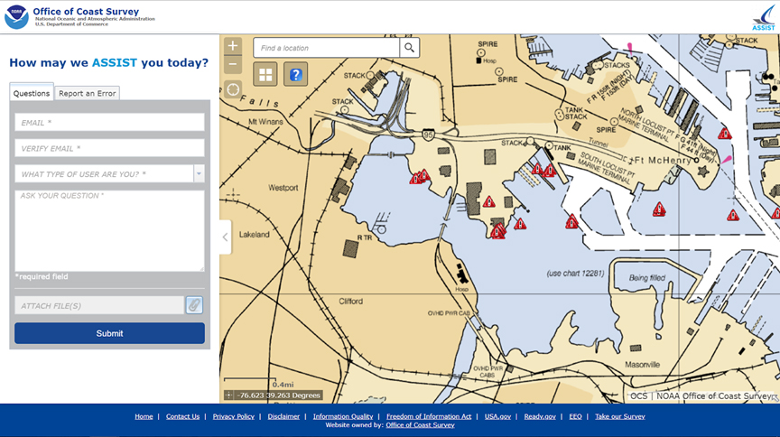
On November 16, 2018, NOAA released ASSIST, a new system for submitting questions and reporting nautical chart errors to NOAA’s Office of Coast Survey. ASSIST has a mobile-friendly design and improved user interface that allows customers to access the system conveniently from any device. This new tool replaces Coast Survey’s Inquiry and Discrepancy Management System (IDMS), a database that collected nearly 20,000 comments, inquiries, and discrepancy reports since 2008. ASSIST is available from: https://www.nauticalcharts.noaa.gov/customer-service/assist/

Continue reading “NOAA makes it easier to submit a comment or report a nautical chart error”

Seismic inter-agency collaborations on NOAA Ship Rainier

Rainier crew practice deploying the Edgetech Sub-bottom 512 Chirp profiler

By Ensign Airlie Pickett, NOAA

NOAA Ship Rainier spent September completing a multi-leg, joint collaboration project investigating deep offshore areas of the southern California coast. The U.S. Geological Survey (USGS) and Bureau of Ocean Energy Management (BOEM) partnered with NOAA to support a month-long mission to collect geophysical data along the outer continental shelf of California where the area in question features a number of different geologic structures and processes.

Continue reading “Seismic inter-agency collaborations on NOAA Ship Rainier”

NOAA Ship Thomas Jefferson successfully tests new wireless system that aids remote vessel operation

By Lt. Charles Wisotzkey, NOAA

NOAA Ship Thomas Jefferson successfully tested a new wireless networking system while working in the Approaches to Houston/Galveston and around Puerto Rico during the 2018 field season. This new system connects the ship and its two hydrographic survey launches, providing a level of wireless connectivity previously unobtainable with traditional wireless communications systems. NOAA anticipates this will increase unmanned system productivity while conducting hydrographic surveys.

Continue reading “NOAA Ship Thomas Jefferson successfully tests new wireless system that aids remote vessel operation”

NOAA and USGS collaborate to fulfill important agency missions in offshore areas along the West Coast

This summer, the Coastal and Marine Geology Program of the U.S. Geological Survey (USGS) and NOAA’s Office of Coast Survey together ran an interagency ocean mapping project across several large portions of the Cascadia Margin, offshore of California, Oregon, and Washington states.
This collaboration,  conducted aboard the NOAA Ship Rainier, used hydrographic surveying equipment to collect swath bathymetry, backscatter intensity data, and full water column data within the project areas. The high-resolution geospatial data acquired will provide key baseline data for targeted USGS studies to improve hazard assessment and forecasting for marine geohazards offshore of northern California, Oregon, and Washington.  NOAA will also use the data to update nautical charts for safe navigation in the region.

Continue reading “NOAA and USGS collaborate to fulfill important agency missions in offshore areas along the West Coast”

NOAA Ship Thomas Jefferson presents survey work to Puerto Rico South Coast stakeholders

By Cmdr. Chris van Westendorp, Commanding Officer of NOAA Ship Thomas Jefferson

Almost one year following the passage and destruction of Hurricane Maria, NOAA Ship Thomas Jefferson has returned to Puerto Rico. Following the storm, Thomas Jefferson deployed in September 2017 for hydrographic hurricane response work in Puerto Rico and the U.S. Virgin Islands (PR/USVI). The ship and crew surveyed 18 individual port facilities to ensure safety of navigation and help re-open the region for maritime commerce. Thomas Jefferson’s second major project of 2018 has brought the ship back to Puerto Rico from August to November, conducting follow-up survey work along the north and south coasts.

Continue reading “NOAA Ship Thomas Jefferson presents survey work to Puerto Rico South Coast stakeholders”

NOAA and Coast Guard survey shallow channels in eastern Chesapeake Bay to update aids to navigation

Echoboat ASV surveys in the Pocomoke River Channel to investigate possible shoaling.

By Lt j.g. Patrick Debroisse

The area of the Chesapeake Bay along the Eastern Shore of Maryland is one of our nation’s treasures. Home to unique underwater grasses, fish, and shellfish, this complex transition from river to sea is also home to millions of tons of sediment delivered annually from eroding land and streams. Recreational boaters, fisherman, and cruising vessels are keenly aware of the shifting sands and sediment deposits in these shallow waters and rely on aids to navigation (ATON) — a system of beacons and buoys — to travel safely to and from the harbors and docks along the shoreline.
Continue reading “NOAA and Coast Guard survey shallow channels in eastern Chesapeake Bay to update aids to navigation”

Crew of NOAA Ship Rainier surveys Everett, Washington, to update charts

By Lt. j.g. Michelle Levano

everett1
RA-6 in Elliott Bay, downtown Seattle. Photo Credit: Lt. Andrew Clos

As NOAA Ship Rainier underwent repairs in South Seattle, the ship’s survey launches and their crews carried out a project to update nautical charts around the Port of Everett and its approaches in Possession Sound. The boats used state-of-the-art positioning and multibeam echo sounder systems to achieve full bottom coverage of the seafloor.
The ports of Seattle, Tacoma, and Everett have experienced an increase in vessel traffic and capacity within the last decade. The Port of Everett serves as an international shipping port bringing jobs, trade, and recreational opportunities to the city. Across Possession Sound, Naval Station Everett is the homeport for five guided-missile destroyers, and two U.S. Coast Guard cutters. The data collected from this project will support additional military traffic transiting to and from Naval Submarine Base Bangor in addition to the Washington State Ferries’ Mukilteo/Clinton ferry route, commercial and tribal fishing, and recreational boating in the area. Continue reading “Crew of NOAA Ship Rainier surveys Everett, Washington, to update charts”

NOAA surveys Lake Champlain for improved flood modeling and mitigation strategies

At the request of the NOAA Great Lakes Environmental Research Lab (GLERL), NOAA’s Office of Coast Survey deployed a survey team and a new autonomous surface vehicle (ASV) to gather hydrographic data in and around the narrow causeway inlets that dot the Lake Champlain basin in Vermont. GLERL will use the data to improve flood forecast models and analyze flood mitigation strategies in the Lake Champlain-Richelieu River system as part of a U.S. and Canada study led by the International Joint Commission.
Continue reading “NOAA surveys Lake Champlain for improved flood modeling and mitigation strategies”

Coast Survey spotlight: Meet Starla Robinson

Starla Robinson served as a crew member on the NOAA Ship Rainier. Photo credit: Lt. Damian Manda, NOAA Corps

Ever wonder what it’s like to be a member of the NOAA Coast Survey team? We will use the Coast Survey spotlight blog series as a way to periodically share the experiences of Coast Survey employees as they discuss their work, background, and advice.


Starla Robinson, Physical Scientist

The work we do has real value and every sounding takes a team of professionals from multiple disciplines. I like being a part of something greater.

Continue reading “Coast Survey spotlight: Meet Starla Robinson”