
Nautical charts are updated with the most current information available through several processes and workflows within NOAA’s Office of Coast Survey. The large majority of these updates consist of revisions to water depth information. The bottom of a water body is changeable by nature, thus hydrographic surveys are constantly necessary to show contemporary depths in a given body of water. What doesn’t happen quite as often are changes to land along the coast, altering the way inlets, harbor entrances, and river mouths appear from a bird’s eye view. Unless there has been a catastrophic event, these changes in land are usually the result of human interaction.
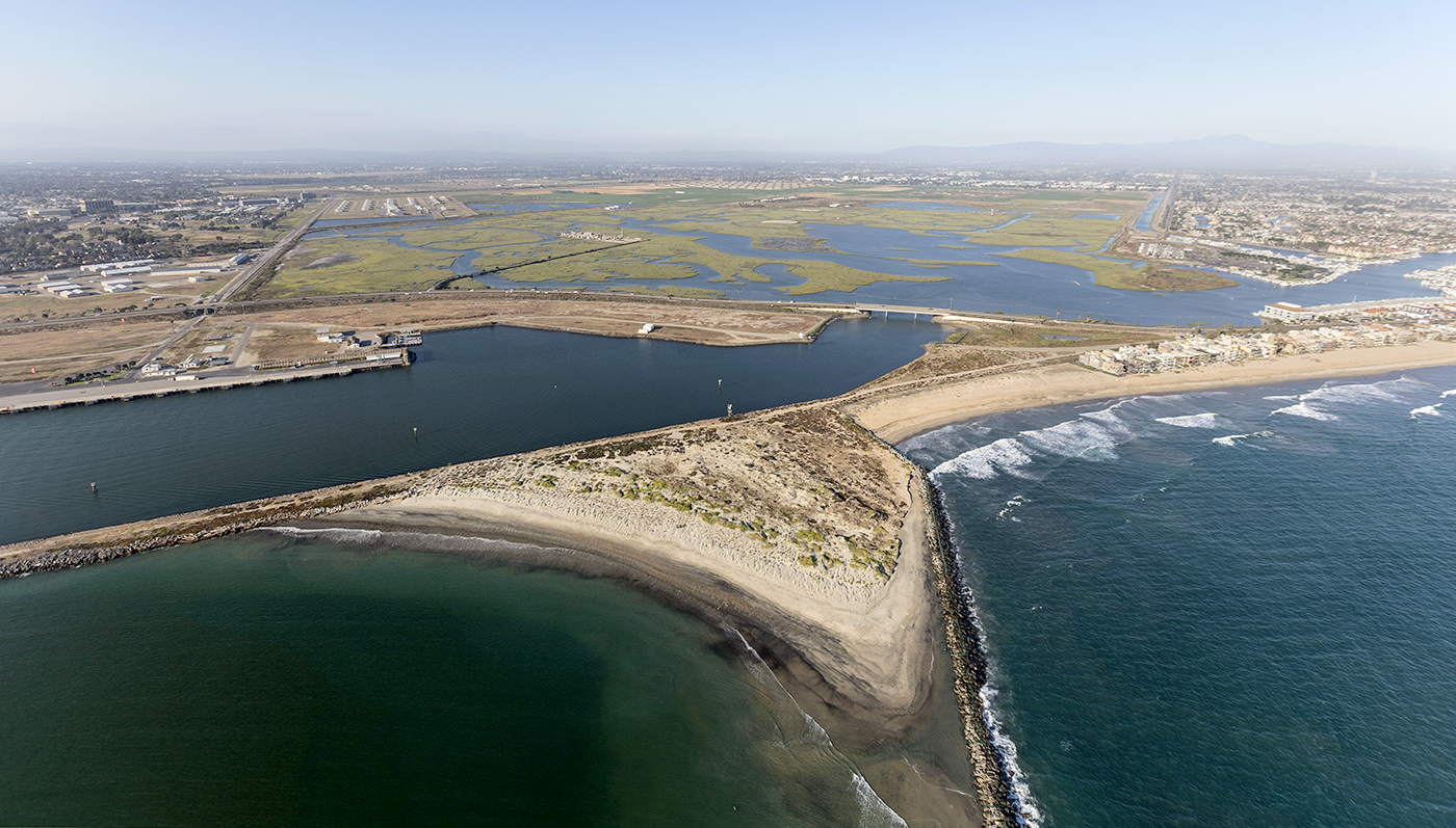
Just down the coast from the Port of Long Beach in California, is Anaheim Bay and Naval Weapons Station Seal Beach. In operation since 1944, the station has evolved into the Navy’s primary West Coast installation for ordnance storage and loading of munitions on medium-sized naval vessels. Southeast of Anaheim Bay is Huntington Harbour – a large community of homes with waterfront access and several marinas with numerous recreational boaters.


Prior to August 2021, the only way for recreational boaters to access Huntington Harbour was through Anaheim Bay resulting in recreational boaters transiting uncomfortably close to the Navy facilities. In 2020, the Navy began a large project to improve the existing pier and creating a new channel to help separate recreational boat traffic from naval vessels. The end result was a new channel and causeway.


The channel opened to traffic in the Spring of 2021, while the Navy was still conducting final dredging and shoreline reinforcements. During this time, the navigation systems of recreational boaters would show them “driving” over land. Updating the chart was essential to provide accurate information and, just as importantly, instill confidence to the end users.
The Office of Coast Survey’s Marine Chart Division is responsible for applying updates to nautical charts. California’s navigation manager contacted the division relaying that the Navy had created a channel to handle civilian traffic for Huntington Harbour and was anxious to have it portrayed on NOAA products. In order to update the nautical chart, it was determined that a hydrographic survey and shoreline data was needed. Within the division, the Nautical Data Branch – which handles all incoming source data – made two shoreline update requests to the National Geodetic Survey’s Remote Sensing Division. This would ensure that new shoreline data was available once the survey was ready for application to the chart.
The navigation manager worked with the Navy to get a final hydrographic survey of the new channel. A final survey was made available in late August 2021, and was delivered to Coast Survey’s Hydrographic Surveys Division (HSD) External Source Data Team on August 27. The team quickly reviewed the data, after requesting some additional metadata and getting the Navy to sign a data release form, and the survey was approved and passed on to HSD’s Pacific Hydrographic Branch on September 15, 2021.
Given its high priority, the branch elevated the survey in the queue and quickly completed an acceptance review of the data. Once the review was complete, the data was then passed on to the Marine Chart Division on October 13, 2021. With hydrographic and shoreline data in hand, the process of updating the nautical chart could begin.
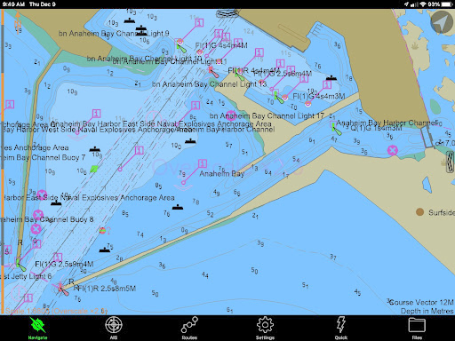
On December 9, 2021 a boater using a navigation system with the proper updates would see the new channel on their chart display system.
Updated nautical charts are obviously important to provide navigation safety to all end users. In this case, it’s highly unlikely that a major accident would have occurred without the chart update. However, it’s important that users have faith in the reliability and accuracy in publicly provided products and services. Thanks to a large team of folks doing an efficient job and passing the data to the next group, this is one instance of an important update that was completed in record time.
How are NOAA charts or maps updated? Does an agency send you something off GIS ?
Updates to NOAA’s suite of nautical charts are situated into two categories, critical corrections and routine corrections. Much of the critical information comes from the U.S. Coast Guard via Local Notice to Mariners. Routine information consists of primarily hydrographic and shoreline surveys from the U.S. Army Corps of Engineers and NOAA’s hydrographic survey vessels.