NOAA contributes to Empowering Women in Hydrography through at-sea experience, part 4

NOAA Ship Thomas Jefferson tied up at the Port of Galveston before departing for its survey leg.

The Empowering Women in Hydrography project is a global effort led by the International Hydrographic Organization and Canada that seeks to initiate, organize and track a series of activities and initiatives which will enable more women to participate equitably in the field of hydrography and to assume leadership roles within the hydrographic community. NOAA is contributing to the project via an ‘at-sea experience’ on NOAA hydrographic ships for three women each year over the lifespan of the project. After a global call for nominations, three women were selected to join NOAA ships for the 2023 survey season. Lt.j.g. Liezel Bastez, a hydrographer surveyor from the Hydrography Branch under the National Mapping and Resource Information Authority (NAMRIA) of the Philippines, joined NOAA Ship Thomas Jefferson from 27 May to 9 June 2023 while surveying the Gulf of Mexico Galveston, Texas.

Continue reading “NOAA contributes to Empowering Women in Hydrography through at-sea experience, part 4”

Nippon Foundation/GEBCO scholar joins NOAA Ship Thomas Jefferson

An image of Thomas Jefferson's survey launch 2903.

By Rebecca Formanek

Staring off into the seemingly infinite blue horizon something inside me asks, what secrets lie beneath the last frontier of this planet? Three weeks aboard NOAA Ship Thomas Jefferson showed me I am not the only one to think this. The talented individuals that comprise the crew of Thomas Jefferson demonstrated the range and dedication to discovering these secrets, and I thank them for sharing their time, knowledge, and experiences. If there is anything that can unite a diverse group of people, it is the sea.

Continue reading “Nippon Foundation/GEBCO scholar joins NOAA Ship Thomas Jefferson”

Planned data collection for Southern Alaska highlights agency partnership

Integrated Ocean and Coastal Mapping (IOCM) is the practice of planning, acquiring, integrating, and sharing ocean and coastal data and related products so that people who need the data can find it and use it easily. NOAA’s IOCM program also aims to make the most of limited resources, with a goal to map once, use many times. The IOCM program is happy to share that the U.S. Geological Survey (USGS) and NOAA have entered into a cost-sharing agreement to conduct mapping activities off Kodiak Island, Alaska in support of Seascape Alaska, a regional mapping campaign. This multiyear study is funded primarily by the USGS on the survey vessel, NOAA Ship Fairweather. NOAA’s Coast Survey is also providing project management, environmental compliance evaluation, data acquisition and processing, and quality assurance. The data will be archived at NOAA’s National Centers for Environmental Information, so that other users can access as well.

Continue reading “Planned data collection for Southern Alaska highlights agency partnership”

The Interagency Working Group on Ocean and Coastal Mapping announces progress report on mapping U.S. ocean, coastal, and Great Lakes waters

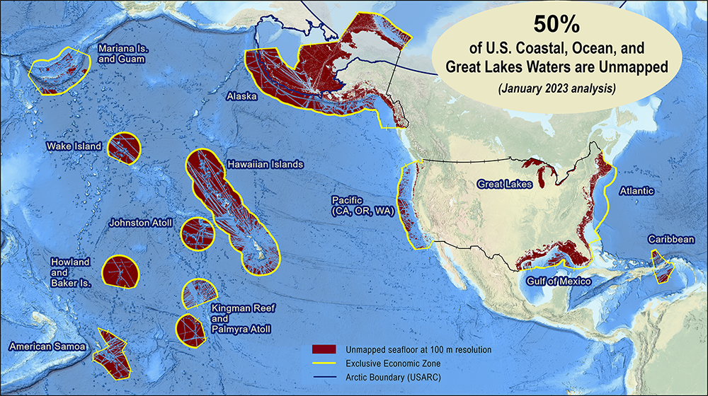
A graphic showing a map of the United States and the percentage of unmapped waters as of January 2023.

The federal Interagency Working Group on Ocean and Coastal Mapping (IWG-OCM) has released the fourth annual report on progress made in mapping U.S. ocean, coastal, and Great Lakes waters. Knowledge of the depth, shape, and composition of the seafloor has far-reaching benefits, including safer navigation, hazard mitigation for coastal resilience, preservation of marine habitats and heritage, and a deeper understanding of natural resources for sustainable ocean economies. The 2020 National Strategy for Mapping, Exploring, and Characterizing the United States Exclusive Economic Zone (NOMEC) and the Nippon Foundation-GEBCO Seabed 2030 Project make comprehensive ocean mapping a priority for the coming decade. The Unmapped U.S. Waters report tracks progress toward these important goals.

Continue reading “The Interagency Working Group on Ocean and Coastal Mapping announces progress report on mapping U.S. ocean, coastal, and Great Lakes waters”

Naming Brennan Reef, a previously uncharted pinnacle in Channel Islands National Marine Sanctuary

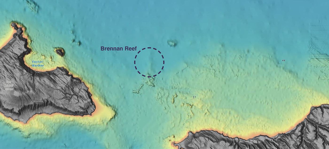
Brennan Reef, shown via shaded relief on the National Centers for Environmental Information bathymetric data viewer.

NOAA Corps Rear Adm. Richard T. “Rick” Brennan, recent director of NOAA’s Office of Coast Survey, was deeply dedicated to NOAA’s mission and was an integral part of building connections across NOAA programs to benefit coastal communities around the United States. One example of Rick’s leadership was the Southern California Seafloor Mapping Initiative, a partnership between Coast Survey, Office of National Marine Sanctuaries (ONMS), National Centers for Coastal Ocean Science (NCCOS) and National Marine Fisheries Service (NMFS). Among many important accomplishments of this coordinated mapping effort was the survey of a previously uncharted reef in Channel Islands National Marine Sanctuary. Through legislative action led by U.S. Congressman Salud Carbajal of California’s 24th District, this reef has been officially designated as “Brennan Reef.”

Continue reading “Naming Brennan Reef, a previously uncharted pinnacle in Channel Islands National Marine Sanctuary”

NOAA releases 2023 hydrographic survey season plans

An image showing all NOAA hydrographic survey vessels.

NOAA hydrographic survey ships, navigation response teams, and contractors are preparing for the 2023 hydrographic survey season. The ships and survey vessels collect bathymetric data (i.e. map the seafloor) to support nautical charting, modeling, and research, but also collect other environmental data to support a variety of ecosystem sciences. NOAA considers hydrographic survey requests from stakeholders such as marine pilots, local port authorities, the Coast Guard, and the boating community, and also considers other hydrographic and NOAA science priorities in determining where to survey and when. Visit our “living” ArcGIS StoryMap to find out more about our mapping projects and if a hydrographic vessel will be in your area this year!

Continue reading “NOAA releases 2023 hydrographic survey season plans”

NOAA Ship Thomas Jefferson completes productive field season in the Great Lakes

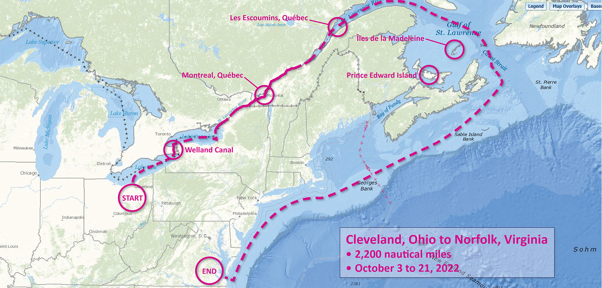
A graphic showing the route NOAA Ship Thomas Jefferson took returning back to Norfolk, Virginia after the 2022 field season.

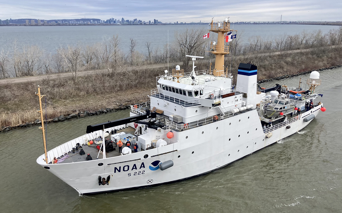
Although NOAA has a significant presence in the Great Lakes, this is the first time a white-hulled NOAA hydrographic ship has deployed there since the early 1990s. As a result of survey work in the Great Lakes, NOAA Ship Thomas Jefferson surveyed 450 square nautical miles of lake bottom in Lake Erie – an economically important and ecologically sensitive region. The ship also surveyed 274 square nautical miles in Lake Ontario in October. In both lakes, there were 42 confirmed and new shipwrecks identified along with 22 additional features!

Continue reading “NOAA Ship Thomas Jefferson completes productive field season in the Great Lakes”

NOAA contributes to Empowering Women in Hydrography through at-sea experience, part 3

An image of Firosa Tomohamat, from Suriname’s Maritime Authority, sitting on a bench on deck 2 of NOAA Ship Thomas Jefferson.

The Empowering Women in Hydrography project is a global effort led by the International Hydrographic Organization and Canada that seeks to initiate, organize and track a series of activities and initiatives which will enable more women to participate equitably in the field of hydrography and to assume leadership roles within the hydrographic community. NOAA is contributing to the project via an ‘at-sea experience’ on NOAA hydrographic ships for three women each year over the four year lifespan of the project. After a global call for nominations, three women were selected to join NOAA ships for the 2022 survey season. Firosa Tomohamat from Suriname’s Maritime Authority, joined NOAA Ship Thomas Jefferson from August 8 to 26, 2022 while surveying the Great Lakes.

Continue reading “NOAA contributes to Empowering Women in Hydrography through at-sea experience, part 3”

NOAA contributes to Empowering Women in Hydrography through at-sea experience, part 2

NOAA ship Thomas Jefferson from survey launch 2904 at sunrise.

The Empowering Women in Hydrography project is a global effort led by the International Hydrographic Organization and Canada that seeks to initiate, organize and track a series of activities and initiatives which will enable more women to participate equitably in the field of hydrography and to assume leadership roles within the hydrographic community. NOAA is contributing to the project via an ‘at-sea experience’ on NOAA hydrographic ships for three women each year over the four year lifespan of the project. After a global call for nominations, three women were selected to join NOAA ships for the 2022 survey season. Chiaki Okada from the Hydrographic and Oceanographic Department, Japan Coast Guard, joined NOAA Ship Thomas Jefferson from July 25 to August 6, 2022 while surveying the Great Lakes.

Continue reading “NOAA contributes to Empowering Women in Hydrography through at-sea experience, part 2”

NOAA contributes to Empowering Women in Hydrography through at-sea experience, part 1

An image showing all woman officer hydrographers standing in front of NOAA Ship Rainier.

The Empowering Women in Hydrography project is a global effort led by the International Hydrographic Organization and Canada that seeks to initiate, organize, and track a series of activities and initiatives which will enable more women to participate equitably in the field of hydrography and to assume leadership roles within the hydrographic community. NOAA is contributing to the project via an ‘at-sea experience’ on NOAA hydrographic ships for three women each year over the four year lifespan of the project. After a global call for nominations, three women were selected to join NOAA ships for the 2022 survey season. Sub-Lieutenant Mercy Modupe Ogungbamila from the Nigerian Navy joined NOAA Ship Rainier from July 5 to 15, 2022 while surveying from Guam to Saipan.

Continue reading “NOAA contributes to Empowering Women in Hydrography through at-sea experience, part 1”