
In late July 2021, the Global Extratropical Surge and Tide Operational Forecast System (Global ESTOFS) upgrade to version two was implemented into operations on the National Weather Service’s (NWS) Weather and Climate Operational Supercomputing System (WCOSS). The modeling system provides forecast guidance for combined water levels caused by storm surge and tides globally, and is to our knowledge the highest resolution global operational storm surge modeling system available today. The forecast guidance from the model is used by forecasters at NWS Weather Forecast Offices (WFO) and the Ocean Prediction Center to generate their storm surge and flood forecasts during storms, including Nor’easters along the U.S. East Coast.
Over the past several months, the Storm Surge Modeling Team within NOAA’s Office of Coast Survey, Coast Survey Development Lab collaborated with the University of Notre Dame to implement many significant advancements in Global ESTOFS to improve model performance, resolution, and coverage. Some of the enhancements are:
- inclusion of federal levees in southern Louisiana;
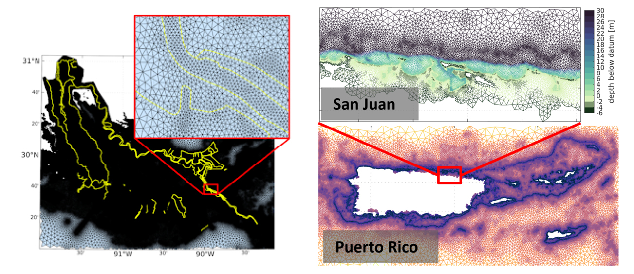
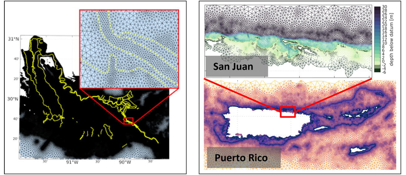
- improved spatial resolution and inclusion of a floodplain for Puerto Rico;
- output of depth-averaged current velocities for use in NOAA’s Nearshore Wave Prediction System, resolving wave-current interactions which improve wave forecast guidance for coastal WFOs; and
- improvements to coastal topobathy and bottom friction, and subsequent performance in coastal flood forecasts.
The model has four forecast cycles per day, providing water level forecast guidance out to 7½ days for users in both the disaster mitigation and marine navigation communities. Users can expect much improved water level forecast guidance with this upgrade. With its new global coverage, the name of the model is planned to change to the Global Surge and Tide Operational Forecast System in July 2022, as it will no longer be specific to just an extratropical forecasting system.
Global ESTOFS output is available on AWS and NOMADS, and visualization available on nowCOAST™ and this NOAA website.
ESTOFS is one of the oldest-running coastal storm surge operational forecast systems, in place operationally since 2012. The system was developed by NOAA’s Office of Coast Survey, Coastal Marine Modeling Branch and was implemented in collaboration with the National Weather Service and University of Notre Dame. As in previous ESTOFS implementations, Global ESTOFS’s new capabilities were implemented during collaborative research and development projects supported by the NOAA Water Initiative, COASTAL Act and NOAA’s Office of Coast Survey research opportunities.
This was the last of any NOAA modeling system upgrade implemented on WCOSS before the moratorium, which will extend into summer 2022. During this time, no new model upgrades will be accepted or implemented onto WCOSS due to the system itself being upgraded to an entirely new supercomputing system, called WCOSS2.
“Thanks to all for getting this model onto WCOSS before the moratorium. An important new forecast capability for the weather and ocean community who have been working together to bring this model implementation over the finish line,” said Louis W. Uccellini, Ph.D., director of NOAA’s National Weather Service.
“Kudos to the Office of Coast Survey team for developing a life-saving upgrade to the global storm surge and tide forecasting system and, more importantly, for operationalizing this system,” said Nicole LeBoeuf, assistant administrator of NOAA’s National Ocean Service.” Through close collaboration with the University of Notre Dame and the National Weather Service, this work exemplifies a successful research to operations partnership. The upgraded forecast system will support safe marine navigation while protecting lives and property along increasingly at-risk coastlines.”
The availability of numerical guidance from Global ESTOFS enhances the ability of NOAA’s National Centers for Environmental Prediction to provide operational extratropical storm surge guidance in synopses found in offshore forecasts and forecasts designed for U.S. Coast Guard broadcast, such as NAVTEX and VOBRA.
Global ESTOFS also is beginning to provide water level forecast guidance to the navigation community as part of NOAA’s Precision Marine Navigation program. Finally, Global ESTOFS storm surge and tide output, now including depth-averaged currents along with water levels, is being used as input to NWS’s Nearshore Wave Prediction System, which provides on-demand, high-resolution nearshore wave model forecast guidance to U.S. coastal WFOs. Additional details are available via the Service Change Notice issued on July 1, 2021.