

The Port of New Orleans, is one of the largest ports in the United States. It spans both sides of the Mississippi River in the state of Louisiana, with its lower limit situated approximately 80 miles above the confluence of three major passes used to access the river from the Gulf of Mexico. The city of New Orleans serves as the primary commercial hub within the port’s limits. As one of the largest cities along the Gulf Coast, it is a natural gateway for trade, connecting the vast central and southern regions of the nation, particularly the entire Mississippi River Valley, via numerous inland water routes.
Navigating the Mississippi River, especially for vessels heading into the port or to destinations upriver, can be challenging. Having the most up-to-date and accurate information about the river is critical. A key component of this information includes the permanent bridges crossing the river, along with their physical dimensions and clearances.
There are no bridges across the Mississippi River below New Orleans, however, eight bridges span the river between New Orleans and Baton Rouge, Louisiana:
- Crescent City Connection Bridges
- Huey P. Long Bridge
- Hale Boggs Memorial Bridge
- Veterans Memorial Bridge
- Sunshine Bridge
- Horace Wilkinson Bridge
- Baton Rouge Highway Bridge

Modern ships navigate U.S. ports with increasingly tight margins—under their keels, beneath bridges, and within narrow channels. As vessels grow in size and port infrastructure remains the same or experiences limited expansion, the margin for error becomes smaller. This emphasizes the need for enhanced navigation data. Accurately representing a bridge’s minimum clearance values available to deep-draft vessels is essential for improving navigational safety, streamlining commerce, and enabling better operational decision-making.
Updating Bridge Clearances
The bridge clearances for these eight bridges crossing the Lower Mississippi River between New Orleans and Baton Rouge are being updated using light detection and ranging, or lidar, derived heights, collected in 2018. Currently, vertical clearances for the bridges are referenced to mean high water on nautical charts which in turn is referenced to the 1927 Flood Stage. Mean high water is a tidal datum that is the average of all the high water heights observed over the National Tidal Datum Epoch. Referencing this datum artificially reduces the vertical clearances for the bridges because mean high water on the Mississippi River is tied to a single historic flood stage and not cyclical tidal influence.
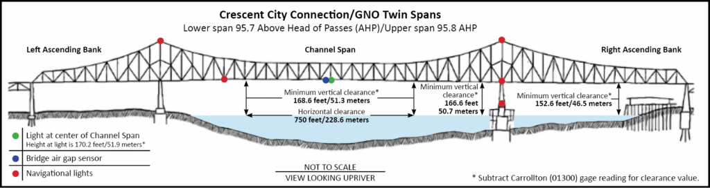
The 2018 lidar surveys are referenced to the low water reference plane—the datum used by the United States Army Corp of Engineers, or USACE—when surveying water depths for the Mississippi River above river mile 13.4. NOAA converted the clearances from the low water reference plane to the local controlling USACE water level gage, known locally as “zero on the gage”. In order to obtain the corrected real-time safe minimum bridge clearance, mariners are required to subtract the latest river stage value provided by the USACE gages from the vertical clearance value shown on the NOAA electronic navigational chart, or NOAA ENC®. For example, if the Carrollton gage is reporting the current river stage as 4 feet, the minimum clearance for the Crescent City Connection bridges would be 166 feet minus 4 feet, or 162 feet.
| Bridge Name (river mile) | Old NOAA ENC clearance (feet) | Updated NOAA ENC clearance (feet) | Nearest USACE gage |
|---|---|---|---|
| Crescent City Connection (95.7/95.8) | 150 | 166 | Carrollton, Louisiana (01300) |
| Huey P. Long (106.1) | 132 | 150 | Carrollton, Louisiana (01300) |
| Hale Boggs (121.5) | 133 | 155 | Reserve, Louisiana (01260) |
| Veterans Memorial, AKA Gramercy (145.9) | 139 | 159 | Reserve, Louisiana (01260) |
| Sunshine (167.4) | 133 | 170 | Donaldsonville, Louisiana (01220) |
| Horace Wilkinson, AKA New Bridge (229.3) | 125 | 165 | Baton Rouge, Louisiana (01160) |
| Baton Rouge HWY 190 (233.9) | 65 | 108 | Baton Rouge, Louisiana (01160) |
Enhanced Tools for Mariners
Each bridge will include an updated graphic known as a pictorial representation, or PICREP, accessible on the NOAA electronic navigational chart. These graphics will highlight key details, such as the location of the minimum vertical clearance, air gap sensors, and navigation lights. They will also indicate the USACE gage needed to determine the current river stage and calculate the minimum vertical clearance. In June 2025, most bridge PICREPs were updated to provide the height of each bridge referenced to the channel span light. On NOAA electronic navigational charts, clearance information will appear as a truncated value. For example, 166.6 feet will be displayed as 166 feet. However, the pictorial representation will show the exact value of 166.6 feet.
NOAA’s United States Coast Pilot 5 will also be updated to reflect the new clearance information. Mariners seeking real-time maximum clearance data can use the Lower Mississippi River PORTS Air Gap sensors for added precision.
Conclusion
The updates to bridge clearances on the Lower Mississippi River represent a significant step forward in ensuring the safety and efficiency of maritime navigation. By leveraging advanced lidar technology and aligning clearance data with modern surveying standards, NOAA is equipping mariners with precise, real-time information to navigate one of the nation’s busiest waterways. NOAA continues to engage with stakeholders to further refine navigational products based on customer feedback and available data. These enhancements will not only improve navigational safety but also support the seamless flow of commerce through the Port of New Orleans and beyond.
NOAA’s commitment to delivering accurate and accessible data highlights the importance of technological innovation in meeting the challenges of modern maritime operations. As vessel sizes continue to grow and margins for error become tighter, these updates will play a crucial role in maintaining the Mississippi River’s status as a critical gateway for trade and transportation.