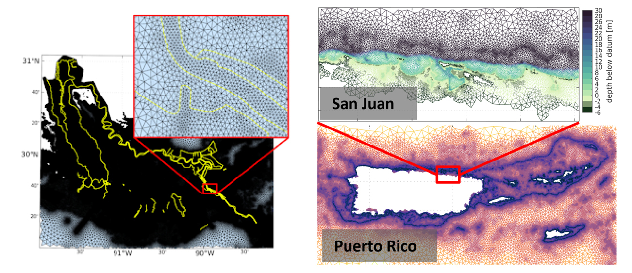
In late July 2021, the Global Extratropical Surge and Tide Operational Forecast System (Global ESTOFS) upgrade to version two was implemented into operations on the National Weather Service’s (NWS) Weather and Climate Operational Supercomputing System (WCOSS). The modeling system provides forecast guidance for combined water levels caused by storm surge and tides globally, and is to our knowledge the highest resolution global operational storm surge modeling system available today. The forecast guidance from the model is used by forecasters at NWS Weather Forecast Offices (WFO) and the Ocean Prediction Center to generate their storm surge and flood forecasts during storms, including Nor’easters along the U.S. East Coast.
Continue reading “Model Upgrade: Global Extratropical Surge and Tide Operational Forecast System Upgraded to Version Two”Aid to navigation recovery operations with NOAA’s Navigation Response Branch and the U.S. Coast Guard
Flushing Bay Channel Lighted Buoy 3 was struck by a tug and barge in late July, and was reported sunk immediately following the strike. The buoy marks the entrance to a channel frequented by commercial barge traffic, specifically, loaded fuel barges bound for LaGuardia International Airport. The Navigation Response Branch (NRB) was called upon in early August to assist United States Coast Guard (USCG) Sector New York in locating the sunken buoy in Flushing Bay, New York.
Continue reading “Aid to navigation recovery operations with NOAA’s Navigation Response Branch and the U.S. Coast Guard”Learning the ropes aboard a NOAA hydrographic survey vessel
By Natalie Cook

University of New Hampshire’s Center for Coastal and Ocean Mapping and NOAA are giving undergraduate students the opportunity to participate in seafloor mapping and associated exercises aboard a survey vessel this summer. Natalie Cook, a junior in the Ocean Engineering program, is spending eight weeks aboard NOAA Ship Thomas Jefferson, a 208-foot hydrographic survey vessel, experiencing all aspects of hydrography. Natalie is standing survey watch, processing data, working on survey launches, and serving as an active member of the hydrographic survey team.
Collecting aerial images on the Chesapeake’s Western Shore
By Tom Loeper
Early in the morning of June 15, John Doroba and Tom Loeper met with Anne Arundel Park Ranger Adam Smith to collect aerial oblique images of several rivers on the Western Shore of the Chesapeake Bay. These images will be used to update existing content in the United States Coast Pilot 3, Atlantic Coast: Sandy Hook, New Jersey to Cape Henry, Virginia. In addition to acquiring images, experience gained during the field exercise will be used to update aerial photography specifications in the Coast Pilot manual.
Continue reading “Collecting aerial images on the Chesapeake’s Western Shore”Surveying the approaches to the Chesapeake Bay
By Ensign Gabriella McGann
After a busy winter in port, NOAA Ship Thomas Jefferson started the 2021 field season in familiar waters, returning to survey the approaches of the Chesapeake Bay. Towards the end of the 2020 field season, the crew of the Thomas Jefferson spent their first 45-day “COVID-19 bubble” on this project. A bubble is formed when crew quarantine and test for COVID-19 prior to crewing the ship, staying isolated onboard until the end of the 45-day period. This protocol is part of the Office of Marine and Aviation Operations (OMAO) COVID-19 mitigation strategy. In April and May of 2021 Thomas Jefferson spent an additional 28 days surveying an area approximately 40 nautical miles east of Virginia Beach, Virginia.
Continue reading “Surveying the approaches to the Chesapeake Bay”Remembering Rear Admiral Richard T. Brennan

It is with great sadness that we inform you of the passing of Rear Admiral Richard “Rick” Brennan, Director of NOAA’s Office of Coast Survey. Rick passed away the evening of Thursday, May 13, 2021. A loyal and deeply empathetic leader, Rick served the NOAA Commissioned Officer Corps and nautical charting community for nearly three decades. Rick will be remembered for his passion for NOAA’s mission, as a role model for countless employees, a talented and knowledgeable hydrographer, and a man dedicated to family and friendship.
Continue reading “Remembering Rear Admiral Richard T. Brennan”Coast Survey to shut down the Raster Navigational Chart Tile Service and other related services
NOAA will shut down its Raster Navigational Chart (RNC) Tile Service and the online RNC Viewer on October 1, 2021. The NOAA Seamless Raster Navigational Chart Services will be shut down on January 1, 2022. This is part of a larger NOAA program to end production and maintenance of all NOAA traditional paper and raster nautical charts that was announced in the Federal Register in November 2019.
Continue reading “Coast Survey to shut down the Raster Navigational Chart Tile Service and other related services”NOAA’s Precision Marine Navigation data service receives first major update
The Precision Marine Navigation (PMN) program has completed the first update of its prototype navigation data service – the PMN data processing and dissemination system and PMN Data Gateway viewer. The data processing and dissemination system provides surface current forecast guidance from NOAA’s forecast systems, in a prototype marine navigation data format. The viewer allows users to visualize the predictions and discover where they are. Both the system and the viewer were updated to include data from the recently upgraded Northern Gulf of Mexico Operational Forecast System (NGOFS2).
Continue reading “NOAA’s Precision Marine Navigation data service receives first major update”Surveying in the Strait of Juan de Fuca during a global pandemic
By Ensign Jessie Spruill and Hydrographic Senior Survey Technician Simon Swart, NOAA Ship Fairweather
Last Thanksgiving, the crew of NOAA Ship Fairweather were busy surveying in one of the country’s busiest waterways. A global maritime entryway to the Pacific Northwest, the Strait of Juan de Fuca sees over 8,000 transits of deep-draft container ships, cargo and chemical carriers, oil tankers, and barges coming to and from Puget Sound and Canada. In addition to industrial shipping, the Strait of Juan de Fuca also supports over 200,000 transits of recreational vessels and Washington State Ferries. Located north of the Olympic Peninsula, the Strait forms the northwestern most border between the contiguous U.S. and Canada. On the American side, the region is home to eight million people including 50 First Nation communities with centuries old cultural ties to traditional fishing.
Continue reading “Surveying in the Strait of Juan de Fuca during a global pandemic”NOAA Custom Chart version 1.0 released to the public
On April 1, 2021, NOAA’s Office of Coast Survey released NOAA Custom Chart version 1.0, a dynamic map tool which enables users to create their own paper and PDF nautical charts derived from the official NOAA electronic navigational chart (NOAA ENC®), NOAA’s premier nautical chart product.
Continue reading “NOAA Custom Chart version 1.0 released to the public”