
The Precision Marine Navigation (PMN) program has completed the first update of its prototype navigation data service – the PMN data processing and dissemination system and PMN Data Gateway viewer. The data processing and dissemination system provides surface current forecast guidance from NOAA’s forecast systems, in a prototype marine navigation data format. The viewer allows users to visualize the predictions and discover where they are. Both the system and the viewer were updated to include data from the recently upgraded Northern Gulf of Mexico Operational Forecast System (NGOFS2).
The prototype PMN data processing and dissemination system was released in summer 2020 to ingest, process, and disseminate NOAA’s navigation datasets that are formatted to meet the International Hydrographic Organizations S-100 framework standard. The system currently provides prototype surface current forecast guidance as S-111 datasets, and incorporates data from NGOFS2 predictions. These datasets can be integrated into navigation display systems, such as portable pilot units or electronic chart display and information systems, providing a decision support tool for mariners.
The new Northern Gulf of Mexico Operational Forecast System S-111 dataset can be found at the NOAA Big Data Program S3 Bucket. The system integrates the previous forecast systems for the northern, northeastern, and northwestern Gulf of Mexico, into one model grid domain. It also extends the model domain covered by the previous forecast systems to include additional areas, and spans the boundary between Panama City, Florida and Veracruz, Mexico. While the previous forecast systems have been retired and are no longer available, output from the systems last three operational days will remain on the dissemination site for 30 days.
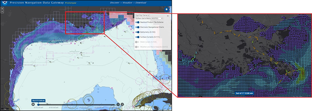
The PMN data service provides NGOFS2 forecast guidance of surface currents out to 48 hours. The S-111 datasets are encoded as HDF5 files and are geospatially subset into small, individual tiles based on NOAA’s Office of Coast Survey nautical product tiling scheme. The tiles are kept small so that they can be downloaded by mariners operating in low bandwidth environments. The Precision Navigation Data Gateway viewer displays the tiles where data is available for downloading, and provides a visualization of the surface current forecast guidance.
The Precision Marine Navigation program will continue to update its data services as new NOAA marine navigation data becomes available. By making this data accessible, these services will support users across the maritime industry to make safe, efficient, and sustainable decisions when it comes to navigation.
The Northern Gulf of Mexico Operational Forecast System was developed and implemented through a collaborative project between NOAA’s Office of Coast Survey, the Center for Operational Products and Services, and the National Weather Service/National Centers for Environmental Prediction central operations. If you have any questions concerning the Precision Marine Navigation data service and this update, please contact marinenav.team@noaa.gov.